Porcupine Ridge

Last updated
Porcupine Ridge
Porcupine Ridge above Goat Haunt.jpg
Northeast aspect
Summit upper left, The Guardhouse behind right
Highest point
Elevation 9,128 ft (2,782 m) [1]
Prominence 1,688 ft (515 m) [1]
Parent peak The Guardhouse (9,341 feet) [2]
Isolation 1.57 mi (2.53 km) [2]
Coordinates 48°55′12″N113°59′00″W / 48.92002067°N 113.98323568°W / 48.92002067; -113.98323568 [3]
Geography
USA Montana relief location map.jpg
Red triangle with thick white border.svg
Porcupine Ridge
Location in Montana
Usa edcp relief location map.png
Red triangle with thick white border.svg
Porcupine Ridge
Location in the United States
Location Glacier National Park
Glacier County, Montana, U.S.
Parent range Livingston Range
Rocky Mountains
Topo map USGS Porcupine Ridge
Geology
Age of rock Precambrian
Type of rock Sedimentary rock

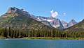
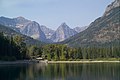
Porcupine Ridge is a prominent mountain ridge located in the Goat Haunt area of Glacier National Park, in Glacier County of the U.S. state of Montana. [3] This mountain is part of the Livingston Range, and is situated 1.5 mile east of the Continental Divide. Topographic relief is significant as the summit rises approximately 3,900 feet (1,200 meters) above Lake Frances in one mile, and nearly 5,000 feet (1,500 meters) above Waterton Lake in five miles. Precipitation runoff from the mountain drains to the Waterton River via Olson and Valentine Creeks. This geographical feature's name was officially adopted in 1911 by the United States Board on Geographic Names. [3]

Contents

Climate

Based on the Köppen climate classification, Porcupine Ridge is located in an alpine subarctic climate zone characterized by long, usually very cold winters, and short, cool to mild summers. [4] Temperatures can drop below −10 °F with wind chill factors below −30 °F. This climate supports the remnant of an unnamed glacier on the northeast aspect below the summit. [5]

Geology

Like the mountains in Glacier National Park, Porcupine Ridge is composed of sedimentary rock laid down during the Precambrian to Jurassic periods. Formed in shallow seas, this sedimentary rock was initially uplifted beginning 170 million years ago when the Lewis Overthrust fault pushed an enormous slab of precambrian rocks 3 mi (4.8 km) thick, 50 miles (80 km) wide and 160 miles (260 km) long over younger rock of the cretaceous period. [6]

See also

Related Research Articles

<span class="mw-page-title-main">Mount Cleveland (Montana)</span> Mountain in Montana, United States

Mount Cleveland is the highest mountain in Glacier National Park, located in Montana, United States. It is also the highest point in the Lewis Range, which spans part of the northern portion of the park and extends into Canada. It is located approximately 3 mi (4.8 km) southeast of the southern end of Waterton Lake, and approximately 5 mi (8.0 km) south of the US–Canada border. The east side of the future national park was purchased by the federal government from the Blackfoot Confederacy in 1895 during the second term of President Grover Cleveland. According to the United States Board on Geographic Names, the mountain is named for the former president.

<span class="mw-page-title-main">Mount Wilbur (Montana)</span> Mountain in the state of Montana

Mount Wilbur is located in the Lewis Range, Glacier National Park in the U.S. state of Montana. Plainly visible from the region of Many Glacier, the peak rises over 4,500 feet (1,372 m) above Swiftcurrent Lake and is a steep pyramid on three sides. The west slopes of the peak join to ridges along the continental divide. Much of the climbing routes are rated at class 4 to 5, with some only used once. The sedimentary rock of the mountains makes for often poor anchoring points and enhances the difficulty. A cirque on the north slopes of the mountain shelters Iceberg Lake, a popular hiking destination from Many Glacier. The mountain was named by George Bird Grinnell in 1885, for Edward R. Wilbur of New York, one of Grinnell's partners in the Forest and Stream Publishing Company, and both men were founders of the Audubon Society.

<span class="mw-page-title-main">Mount Siyeh</span>


Mount Siyeh, with a height of 10,019 feet (3,054 m), is the fifth tallest and one of six peaks over 10,000 feet (3,048 m) in Glacier National Park, Montana, United States. Mount Siyeh was named after a Blackfeet Indian, Sai-yeh, whose name means "Crazy Dog" or "Mad Wolf."

<span class="mw-page-title-main">Goat Mountain (Glacier County, Montana)</span> Mountain in the state of Montana

Goat Mountain is located in the Lewis Range, Glacier National Park in the U.S. state of Montana. Goat Mountain rises above Otokomi Lake and Goat Lake in the east central section of Glacier National Park.

<span class="mw-page-title-main">Iceberg Peak (Montana)</span> Mountain in Montana, USA

Iceberg Peak is located in the Lewis Range, Glacier National Park in the U.S. state of Montana. Iceberg Peak rises more than 3,000 feet (910 m) above Iceberg Lake and is considered a difficult climb due to the steepness and exposure climbers must endure. The peak sits astride the continental divide 1.1 mi (1.8 km) WNW of Mount Wilbur.

<span class="mw-page-title-main">Ipasha Peak</span> Mountain in the state of Montana

Ipasha Peak is located in the Lewis Range, Glacier National Park in the U.S. state of Montana. Ipasha Peak is 1.29 miles (2.08 km) south of Mount Merritt and is in the northeastern section of Glacier National Park. Ahern Glacier is located on the southeastern slopes of the mountain while the Ipasha Glacier is to the southwest of the peak. Helen Lake lies almost 4,500 feet (1,400 m) below the summit of Ipasha Peak to the southeast.

<span class="mw-page-title-main">Kootenai Peak</span> Mountain in the state of Montana

Kootenai Peak is located in the Lewis Range, Glacier National Park in the U.S. state of Montana. Kootenai Peak is in the northeastern section of Glacier National Park.

<span class="mw-page-title-main">Piegan Mountain</span> Mountain in the state of Montana

Piegan Mountain is located in the Lewis Range, Glacier National Park in the U.S. state of Montana. Piegan Glacier is located in a cirque immediately southeast of the summit.

<span class="mw-page-title-main">Bearhat Mountain</span> Mountain in Montana, United States

Bearhat Mountain is located in the Lewis Range, Glacier National Park in the U.S. state of Montana. Bearhat Mountain is immediately west of Hidden Lake. The mountain was named after a Kootenai Native American, and was officially adopted by the U.S. Board on Geographic Names in 1932.

<span class="mw-page-title-main">Campbell Mountain</span>

Campbell Mountain is located in the Livingston Range, Glacier National Park in the U.S. state of Montana. Campbell Mountain rises more than 4,000 feet (1,200 m) above the west shore of Waterton Lake. The mountain is named after Archibald Campbell, who played a role in mapping the international border.

<span class="mw-page-title-main">Mount Cannon</span> Mountain in the state of Montana

Mount Cannon is located in the Lewis Range, Glacier National Park in the U.S. state of Montana. Formerly called Goat Mountain it was renamed for the leading physiologist Dr. Walter Bradford Cannon and his wife Cornelia, who made the first recorded ascent of the mountain in 1901.

<span class="mw-page-title-main">Vimy Peak</span> Mountain in Waterton Lakes NP, Canada

Vimy Peak is a 2,385-metre (7,825-foot) summit located in Waterton Lakes National Park, in the Canadian Rockies of Alberta, Canada. It is set along the east shore of Waterton Lake on the opposite side from Waterton Park townsite. It is situated 5.4 km west of Sofa Mountain, and the nearest higher neighbor is Arras Peak, 3.1 km (1.9 mi) to the southeast. Vimy Peak anchors the northern end of Vimy Ridge, which stretches three kilometers to Arras Peak anchoring the southern end.

<span class="mw-page-title-main">Olson Mountain</span> Mountain in Glacier National Park, US

Olson Mountain, also known as Mount Olson, is a 7,913-foot-elevation mountain summit located in the Livingston Range, of Glacier National Park in the U.S. state of Montana. Olson Mountain rises more than 3,700 feet (1,100 m) above the western shore of Waterton Lake. The mountain was named for a surveyor on the International Boundary Survey, with the name officially adopted in 1929. The nearest higher peak is Campbell Mountain, 1.13 miles (1.82 km) to the north, and Citadel Peaks is two miles to the south. Precipitation runoff from the mountain drains into Olson Creek before it empties to Waterton Lake.

<span class="mw-page-title-main">Stanton Mountain</span> Mountain summit in the Livingston Range

Stanton Mountain is a 7,750 feet (2,360 m) mountain summit located in the Livingston Range, of Glacier National Park in the U.S. state of Montana. Stanton Mountain rises more than 4,500 feet (1,400 m) above the northern shore of Lake McDonald. The mountain's name refers to Mrs. Lottie Stanton who lived near the west side of the park in the late 1800s, and with her husband operated a livery stable in historic Demersville. She was a pioneering woman who followed the construction camps during the railroad building days. The mountain's name was officially adopted in 1929. In the late 1800s it was known as Mt. Lottie Stanton. The nearest higher peak is Mount Vaught, 1.38 miles (2.22 km) to the northeast. Precipitation runoff from the mountain drains into tributaries of the Flathead River.

<span class="mw-page-title-main">Angel Wing (Glacier National Park)</span> Mountain in the state of Montana

Angel Wing is a 7,430-foot (2,260-meter) elevation mountain summit located in the Lewis Range, of Glacier National Park in the U.S. state of Montana. It is situated one mile east of the Continental Divide, in Glacier County. It can be seen from the Many Glacier area, and up close from the Grinnell Glacier Trail. Topographic relief is significant as the north aspect rises nearly 2,500 feet above Grinnell Lake in one-half mile.

<span class="mw-page-title-main">Clyde Peak</span> Mountain in the state of Montana

Clyde Peak is an 8,610-foot-elevation (2,620-meter) mountain summit located in Glacier National Park in the U.S. state of Montana. The mountain straddles the border shared by Flathead County and Glacier County. It is situated on the Continental Divide so precipitation runoff from the west side of the mountain drains into Thompson Creek which is part of the Middle Fork Flathead River watershed, and the east side drains into headwaters of Red Eagle Creek, which flows to Red Eagle Lake, thence Saint Mary Lake. It is set in the Lewis Range, and the nearest higher neighbor is Mount Logan 1.44 mile to the northwest. Topographic relief is significant as the southwest aspect rises approximately 4,000 feet in one mile.

<span class="mw-page-title-main">Spot Mountain</span> Mountain summit in Montana, USA

Spot Mountain is a 7,831-foot-elevation (2,387-meter) mountain summit located in the Two Medicine area of Glacier National Park, in Glacier County, Montana, United States. It is situated in the Lewis Range, nine miles northwest of East Glacier Park Village, and approximately five miles east of the Continental Divide. Precipitation runoff from the mountain drains into tributaries of Cut Bank Creek and Two Medicine River, which merge to form the Marias River. Topographic relief is significant as the south aspect rises nearly 3,000 feet above Lower Two Medicine Lake in two miles. The mountain's name was officially adopted in 1929 by the United States Board on Geographic Names.

<span class="mw-page-title-main">Citadel Peaks</span> Mountain in the state of Montana

Citadel Peaks is a mountain ridge located in the Goat Haunt area of Glacier National Park, in Glacier County of the U.S. state of Montana. This arête with a row of sharp points is part of the Livingston Range, and is approximately four miles east of the Continental Divide. Neighbors include Olson Mountain, two miles (3.2 km) to the north, Mount Cleveland four miles (6.4 km) to the east, and Kootenai Peak 2.7 miles (4.3 km) to the south. Topographic relief is significant as Citadel Peaks rises over 3,800 feet above Waterton Lake in less than two miles, and 3,000 feet above Lake Janet in one mile. Precipitation runoff from the mountain drains to the south end of Waterton Lake. The first ascent of Citadel Spire, a major pinnacle on the ridge, was made in 1967 by Jerry Kanzler, Jim Kanzler, Ray Martin, and Clare Pogreba. This geographical feature's name was officially adopted in 1929 by the United States Board on Geographic Names. To the Pikuni people, Citadel Peaks is known as "Ataniawxis", meaning "The Needles".

<span class="mw-page-title-main">Crypt Peak</span> Mountain summit in Glacier National Park

Crypt Peak is an 8,579-foot (2,615 m) mountain summit located in Glacier National Park, in Glacier County of the U.S. state of Montana. It is situated along the Canada–United States border, above Crypt Lake, and is partially within Waterton Lakes National Park. Crypt Peak is part of the Lewis Range, and is approximately three miles east of Waterton Lake. Topographic relief is significant as Crypt Peak rises over 2,100 feet above Crypt Lake in approximately one-half mile (1.6 km), and 4,400 ft (1,340 m) above Waterton Lake in three miles (4.8 km). Precipitation runoff from the mountain drains west to Waterton Lake, and east to Belly River. This geographical feature's name has not yet been officially adopted by the United States Board on Geographic Names.

<span class="mw-page-title-main">Sentinel Mountain (Montana)</span> Mountain in the American state of Montana

Sentinel Mountain is an 8,245-foot-elevation (2,513 meter) summit in Glacier County, Montana, United States.

References

  1. 1 2 "Porcupine Ridge, Montana". Peakbagger.com. Retrieved 2021-10-18.
  2. 1 2 "Porcupine Ridge - 9,128' MT". listsofjohn.com. Retrieved 2021-10-18.
  3. 1 2 3 "Porcupine Ridge". Geographic Names Information System . United States Geological Survey, United States Department of the Interior . Retrieved 2021-10-18.
  4. Peel, M. C.; Finlayson, B. L.; McMahon, T. A. (2007). "Updated world map of the Köppen−Geiger climate classification" (PDF). Hydrol. Earth Syst. Sci. 11 (5): 1633–1644. Bibcode:2007HESS...11.1633P. doi: 10.5194/hess-11-1633-2007 . ISSN   1027-5606. S2CID   9654551.
  5. Scribner's Magazine, Volume 65, 1919, page 397.
  6. Gadd, Ben (2008). "Geology of the Rocky Mountains and Columbias".{{cite journal}}: Cite journal requires |journal= (help)