Monroe County is a county in the U.S. state of Wisconsin. As of the 2010 census, the population was 44,673. Its county seat is Sparta.

Forest County is a county in the U.S. state of Wisconsin. As of the 2010 census, the population was 9,304. Its county seat is Crandon.

Grandview is a town in Bayfield County, Wisconsin, United States. The population was 468 at the 2010 census. The unincorporated community of Grand View is located in the town of Grandview.

Peru is a town in Clinton County in the U.S. state of New York. The population was 6,998 at the 2010 census. The town was so named for its views of the Adirondack Mountains to the west and the farmlands throughout the town, resembling scenery found in the country of Peru in South America. Peru, New York is in the southeastern part of Clinton County, south of Plattsburgh.

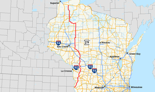
State Trunk Highway 29 is a state highway running east–west across central Wisconsin. It is a major east–west corridor connecting the Twin Cities and the Chippewa Valley with Wausau and Green Bay. A multi-year project to upgrade the corridor to a four-lane freeway or expressway from Elk Mound to Green Bay was completed in 2005. The expansion served to improve safety on the route, which was over capacity as a two-lane road. The remainder of WIS 29 is two-lane surface road or urban multi-lane road.
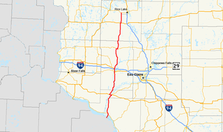
State Trunk Highway 13 is a Wisconsin state highway running north–south across northwest and central Wisconsin. WIS 13 serves as a major north–south route connecting the communities of Wisconsin Dells, Wisconsin Rapids, Marshfield and Ashland. Highway 13 is part of the Lake Superior Circle Tour from its northern/western terminus to Ashland at is eastern junction with U.S. Highway 2. The road also provides access to the Apostle Islands National Lakeshore off the Lake Superior shoreline at Bayfield. The highway is two-lane surface road with the exception of various urban multilane road sections.
U.S. Highway 10 (US 10) in Wisconsin runs east–west across the central part of the state. It runs from the Prescott Drawbridge over the St. Croix River at Prescott east to the dock in Manitowoc where the SS Badger crosses Lake Michigan to Ludington, Michigan. The highway is also designated as the Vietnam War Veterans Memorial Highway for its entire length.

State Trunk Highway 19 is a state highway in the U.S. state of Wisconsin. It provides a more direct route from U.S. Highway 14 near Mazomanie east to Highway 16 at Watertown, passing around the north side of Madison. WIS 19 is a local connector route that links the communities of Waunakee, Sun Prairie and Watertown. The highway follows two lane surface road for the entire length with the exception of urban multilane arterials.

State Trunk Highway 21 is a state highway in the U.S. state of Wisconsin. It runs east–west across the center of the state between Sparta, Wisconsin and Oshkosh. The route often serves as a direct route for travelers between Appleton and Oshkosh to Tomah, and La Crosse It is a two-lane surface road for nearly all of its length, with the exception of a few urban arterials of four or more lanes. The section of WIS 21 between Fort McCoy and I-94 in Tomah is classified as a "Major STRAHNET Connector." while the route past I-94 is classified as a "Non-Interstate STRAHNET Route"

State Trunk Highway 22 is a state highway in the U.S. state of Wisconsin. The route's trajectory is mostly south to north, with the exception of the segment between Shawano and the northern terminus being east–west. It is generally a two-lane surface road providing a connecting route between Waupaca, Shawano, Gillett and Oconto. Various urban sections have multilane segments.

State Trunk Highway 23 is a state highway in the U.S. state of Wisconsin. The route is signed as a north–south route from Shullsburg to Wisconsin Dells and as an east–west route from Wisconsin Dells to Sheboygan. With the exception of freeway segments between Sheboygan Falls and Sheboygan, an expressway segment between Sheboygan Falls and near Greenbush, a freeway concurrency with I-39, and an expressway segment concurrent with U.S. Route 151, the highway is generally either two-lane surface road or urban multilane arterial. WIS 23 provides access to several important Wisconsin destinations, such as the House on the Rock, the Wisconsin Dells area and various state parks.
State Trunk Highway 25 is a state highway in the U.S. state of Wisconsin. The route serves local traffic in the western part of the state, connecting Durand, Menomonie and Barron. It is two-lane surface road with the exception of urban multilanes within Menomonie.
State Trunk Highway 27 is a state highway in the U.S. state of Wisconsin. The highway spans a length of 294 miles (473 km) and is generally two-lane local road with the exception of urban multilane arterials within some cities. Earlier routing of the highway had it reaching Superior along the present US 53 and Fennimore along the present US 61 and following I-94 between Black River Falls and Osseo.
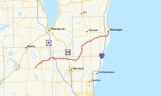
State Trunk Highway 28 is a state highway in the U.S. state of Wisconsin. It runs east–west in southeastern Wisconsin between Horicon and Sheboygan. The route is 59.77 miles (96.19 km) long and is generally two-lane road beyond portions of the road within the city of Sheboygan and the half-mile portion of the highway near Waldo which is concurrent with STH 57.
State Trunk Highway 44 is a state highway in the U.S. state of Wisconsin. It runs in a diagonal southwest–northeast direction in east-central Wisconsin from Pardeeville to Oshkosh.
State Trunk Highway 73 is a state highway in the U.S. state of Wisconsin. It runs north–south across central Wisconsin from Ingram to near Edgerton, with the exception of Wood and Adams counties, where this highway runs east–west. It is one of the longer Wisconsin state highways at 265.8 miles (427.8 km).
The West Branch of the Souhegan River is a 3.1-mile-long (5.0 km) river in southern New Hampshire in the United States. It is a tributary of the Souhegan River, which flows to the Merrimack River and ultimately to the Gulf of Maine.

Addison is a town in Addison County, Vermont, United States. It was founded October 14, 1761. The population was 1,371 at the 2010 census.

Jefferson Junction is an unincorporated community located in the town of Aztalan, Jefferson County, Wisconsin, United States. Jefferson Junction is located at a Union Pacific Railroad junction 2.5 miles (4.0 km) north of Jefferson.


