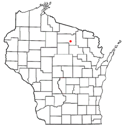
Pelican, Wisconsin

Last updated

Pelican, Wisconsin
WIMap-doton-Pelican.png
Location of Pelican, Wisconsin
Coordinates: 45°36′37″N89°21′29″W / 45.61028°N 89.35806°W / 45.61028; -89.35806
Country Flag of the United States.svg  United States
State Flag of Wisconsin.svg  Wisconsin
County Oneida
Area
  Total54.1 sq mi (140.2 km2)
  Land51.5 sq mi (133.3 km2)
  Water2.7 sq mi (7.0 km2)
Elevation
[1]
1,575 ft (480 m)
Population
 (2000)
  Total2,902
  Density56.4/sq mi (21.8/km2)
Time zone UTC-6 (Central (CST))
  Summer (DST) UTC-5 (CDT)
Area code(s) 715 & 534
FIPS code 55-61625 [2]
GNIS feature ID1583903 [1]

Pelican is a town in Oneida County, Wisconsin, United States. The population was 2,902 at the 2000 census. The unincorporated community of Malvern is located in the town. The town took its name from Pelican Lake. [3]

Contents

Geography

According to the United States Census Bureau, the town has a total area of 54.2 square miles (140.2 km2), of which, 51.5 square miles (133.3 km2) of it is land and 2.7 square miles (7.0 km2) of it (4.99%) is water.

Climate

Climate data for North Pelican, Wisconsin, 1991–2020 normals, 1950-2020 extremes: 1610ft (491m)
MonthJanFebMarAprMayJunJulAugSepOctNovDecYear
Record high °F (°C)51
(11)
58
(14)
75
(24)
88
(31)
92
(33)
97
(36)
98
(37)
97
(36)
93
(34)
86
(30)
72
(22)
58
(14)
98
(37)
Mean maximum °F (°C)40.5
(4.7)
48.1
(8.9)
60.3
(15.7)
77.2
(25.1)
83.2
(28.4)
86.6
(30.3)
87.4
(30.8)
86.1
(30.1)
81.6
(27.6)
74.1
(23.4)
55.1
(12.8)
43.6
(6.4)
89.9
(32.2)
Mean daily maximum °F (°C)20.9
(−6.2)
26.5
(−3.1)
38.2
(3.4)
51.8
(11.0)
65.7
(18.7)
73.9
(23.3)
76.8
(24.9)
74.5
(23.6)
65.8
(18.8)
53.0
(11.7)
36.6
(2.6)
25.2
(−3.8)
50.7
(10.4)
Daily mean °F (°C)12.2
(−11.0)
15.3
(−9.3)
26.3
(−3.2)
39.5
(4.2)
51.8
(11.0)
60.8
(16.0)
64.3
(17.9)
62.9
(17.2)
55.0
(12.8)
43.7
(6.5)
29.6
(−1.3)
17.3
(−8.2)
39.9
(4.4)
Mean daily minimum °F (°C)3.5
(−15.8)
4.2
(−15.4)
14.3
(−9.8)
27.2
(−2.7)
37.9
(3.3)
47.6
(8.7)
51.8
(11.0)
51.4
(10.8)
44.3
(6.8)
34.4
(1.3)
22.5
(−5.3)
9.3
(−12.6)
29.0
(−1.6)
Mean minimum °F (°C)−25.6
(−32.0)
−24.5
(−31.4)
−15.3
(−26.3)
7.0
(−13.9)
22.8
(−5.1)
32.7
(0.4)
37.3
(2.9)
35.5
(1.9)
27.4
(−2.6)
17.0
(−8.3)
0.6
(−17.4)
−17.2
(−27.3)
−28.8
(−33.8)
Record low °F (°C)−46
(−43)
−48
(−44)
−40
(−40)
−8
(−22)
15
(−9)
25
(−4)
28
(−2)
29
(−2)
19
(−7)
4
(−16)
−17
(−27)
−35
(−37)
−48
(−44)
Average precipitation inches (mm)1.20
(30)
1.00
(25)
1.68
(43)
2.64
(67)
3.32
(84)
3.84
(98)
4.67
(119)
3.18
(81)
3.96
(101)
3.18
(81)
2.15
(55)
1.41
(36)
32.23
(820)
Average snowfall inches (cm)14.4
(37)
9.8
(25)
10.4
(26)
5.1
(13)
0.2
(0.51)
0.0
(0.0)
0.0
(0.0)
0.0
(0.0)
0.0
(0.0)
1.0
(2.5)
8.2
(21)
12.1
(31)
61.2
(156.01)
Source 1: NOAA (1981-2010 precipitation) [4] [5]
Source 2: XMACIS (1991-2004 snowfall, temp records & monthly max/mins) [6]

Demographics

As of the census [2] of 2000, there were 2,902 people, 1,167 households, and 820 families residing in the town. The population density was 56.4 people per square mile (21.8/km2). There were 1,532 housing units at an average density of 29.8 per square mile (11.5/km2). The racial makeup of the town was 98.07% White, 0.28% Native American, 0.52% Asian, 0.03% Pacific Islander, 0.03% from other races, and 1.07% from two or more races. Hispanic or Latino of any race were 0.31% of the population.

There were 1,167 households, out of which 31.3% had children under the age of 18 living with them, 59.6% were married couples living together, 6.9% had a female householder with no husband present, and 29.7% were non-families. 25.1% of all households were made up of individuals, and 10.6% had someone living alone who was 65 years of age or older. The average household size was 2.49 and the average family size was 2.97.

In the town, the population was spread out, with 25.2% under the age of 18, 5.7% from 18 to 24, 28.8% from 25 to 44, 26.8% from 45 to 64, and 13.5% who were 65 years of age or older. The median age was 40 years. For every 100 females, there were 104.2 males. For every 100 females age 18 and over, there were 99.4 males.

The median income for a household in the town was $36,053, and the median income for a family was $44,423. Males had a median income of $38,169 versus $20,861 for females. The per capita income for the town was $18,566. About 5.3% of families and 6.2% of the population were below the poverty line, including 5.7% of those under age 18 and 3.1% of those age 65 or over.

Transportation

The Rhinelander-Oneida County Airport (KRHI) serves Pelican, the county and surrounding communities with both scheduled commercial jet service and general aviation services.

Related Research Articles

Prattsburgh is a town in Steuben County, New York, United States. The population was 1,985 at the 2020 census. It is situated in the northeast part of the county, north of Bath.

<span class="mw-page-title-main">Springville, Wisconsin</span> Town in Wisconsin, United States

Springville is a town in Adams County in the U.S. state of Wisconsin. The population was 1,318 at the 2010 census.

<span class="mw-page-title-main">Hobart, Wisconsin</span> Village in Wisconsin, United States

Hobart is a village in Brown County in the U.S. state of Wisconsin. The population was 10,211 at the 2020 census. Hobart is a part of the Green Bay Metropolitan Statistical Area. The village is located entirely within the former treaty boundaries of the Oneida Nation of Wisconsin.

<span class="mw-page-title-main">Elcho, Wisconsin</span> Town in Wisconsin, United States

Elcho is a town in Langlade County, Wisconsin, United States. The population was 1,233 at the 2010 census. The census-designated places of Elcho, Post Lake, and part of Summit Lake are located in the town. The area is served by the Elcho Fire and Rescue Department.

<span class="mw-page-title-main">Underhill, Wisconsin</span> Town in Wisconsin, United States

Underhill is a town in Oconto County, Wisconsin, United States. The population was 846 at the 2000 census.

<span class="mw-page-title-main">Cassian, Wisconsin</span> Town in Wisconsin, United States

Cassian is a town in Oneida County, Wisconsin, United States. The population was 962 at the 2000 census. The unincorporated communities of Goodnow and Harshaw are located in the town.

<span class="mw-page-title-main">Crescent, Wisconsin</span> Town in Wisconsin, United States

Crescent is a town in Oneida County, Wisconsin, United States. The population was 2,071 at the 2000 census. The unincorporated community of Crescent Corner is located in the town.

<span class="mw-page-title-main">Little Rice, Wisconsin</span> Town in Wisconsin, United States

Little Rice is a town in Oneida County, Wisconsin, United States. The population was 314 at the 2000 census. The unincorporated community of McCord is located in the town.

<span class="mw-page-title-main">Lynne, Wisconsin</span> Town in Wisconsin, United States

Lynne is a town in Oneida County, Wisconsin, United States. The population was 210 at the 2000 census. The unincorporated communities of Clifford and Tripoli are located partially in the town.

<span class="mw-page-title-main">Monico, Wisconsin</span> Town in Wisconsin, United States

Monico is a town in Oneida County, Wisconsin, United States. The population was 260 at the 2020 census. The unincorporated community of Monico is located in the town.

<span class="mw-page-title-main">Newbold, Wisconsin</span> Town in Wisconsin, United States

Newbold is a town in Oneida County, Wisconsin, United States. The population was 2,710 at the 2000 census. Tom Doyle Lake and the unincorporated communities of McNaughton and Newbold are located in the town.

<span class="mw-page-title-main">Nokomis, Wisconsin</span> Town in Wisconsin, United States

Nokomis is a town in Oneida County, Wisconsin, United States. The population was 1,371 at the 2010 census.

<span class="mw-page-title-main">Rhinelander, Wisconsin</span> City in Wisconsin, United States

Rhinelander is a city in and the county seat of Oneida County, Wisconsin, United States. The population was 8,285 at the 2020 census.

<span class="mw-page-title-main">Schoepke, Wisconsin</span> Town in Wisconsin, United States

Schoepke is a town in Oneida County, Wisconsin, United States. The population was 352 at the 2000 census. The unincorporated communities of Jennings, Lennox, Pelican Lake, and Pratt Junction are located in the town.

<span class="mw-page-title-main">Stella, Wisconsin</span> Town in Wisconsin, United States

Stella is a town in Oneida County, Wisconsin, United States. The population was 633 at the 2000 census. The unincorporated community of Starks is located within the town.

<span class="mw-page-title-main">Sugar Camp, Wisconsin</span> Town in Wisconsin, United States

Sugar Camp is a town in Oneida County, Wisconsin, United States. The population was 1,694 at the 2010 census. The unincorporated community of Sugar Camp is located in the town

<span class="mw-page-title-main">Woodboro, Wisconsin</span> Town in Wisconsin, United States

Woodboro is a town in Oneida County, Wisconsin, United States. The population was 685 at the 2000 census. The unincorporated community of Woodboro is located in the town. The ghost town of Manson was located in the town.

Woodruff is a town in Oneida County, Wisconsin, United States. The population was 2,055 at the 2010 census. The census-designated place of Woodruff is located in the town.

Oneida is a town in Outagamie County, Wisconsin, United States. The population was 4,001 at the 2000 census. The unincorporated communities of Chicago Corners and Oneida are located in the town. The town occupies the Outagamie County portion of Wisconsin's Oneida Nation of Wisconsin.

<span class="mw-page-title-main">Oneida, Wisconsin</span> Unincorporated community in Wisconsin, United States

Oneida is an unincorporated community and former census-designated place (CDP) in the Town of Oneida, Outagamie County, Wisconsin, United States. The population was 1,070 at the 2000 census. At the census, part of the CDP lay within the Town of Hobart, which has since incorporated as a village, in adjacent Brown County. Oneida is located on Wisconsin Highway 54.

References

  1. 1 2 "US Board on Geographic Names". United States Geological Survey. October 25, 2007. Retrieved January 31, 2008.
  2. 1 2 "U.S. Census website". United States Census Bureau . Retrieved January 31, 2008.
  3. Chicago and North Western Railway Company (1908). A History of the Origin of the Place Names Connected with the Chicago & North Western and Chicago, St. Paul, Minneapolis & Omaha Railways. p. 112.
  4. "North Pelican, Wisconsin 1991-2020 Monthly Normals" . Retrieved December 25, 2023.
  5. "North Pelican, Wisconsin 1981-2010 Monthly Normals" . Retrieved December 25, 2023.
  6. "xmACIS". National Oceanic and Atmospheric Administration. Retrieved December 25, 2023.