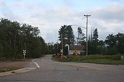
Oneida is an unincorporated community and former census-designated place (CDP) in the Town of Oneida, Outagamie County, Wisconsin, United States. The population was 1,070 at the 2000 census. At the census, part of the CDP lay within the Town of Hobart, which has since incorporated as a village, in adjacent Brown County. Oneida is located on Wisconsin Highway 54.

McNaughton is an unincorporated community located in Oneida County, Wisconsin, United States. McNaughton is located on Wisconsin Highway 47 northwest of Rhinelander, in the town of Newbold.
Lake Tomahawk is an unincorporated census-designated place located in the town of Lake Tomahawk, Oneida County, Wisconsin, United States. Lake Tomahawk is located on Wisconsin Highway 47 15 miles (24 km) northwest of Rhinelander. Lake Tomahawk has a post office with ZIP code 54539. As of the 2010 census, its population was 228.

Hazelhurst is an unincorporated community located in the town of Hazelhurst, Oneida County, Wisconsin, United States. Hazelhurst is located on U.S. Route 51 19 miles (31 km) northwest of Rhinelander. Hazelhurst has a post office with ZIP code 54531.

Monico is an unincorporated community located in the town of Monico, Oneida County, Wisconsin, United States. Monico is located on Venus Lake at the junction of U.S. Route 8, U.S. Route 45, and Wisconsin Highway 47 13 miles (21 km) east-southeast of Rhinelander.

Minocqua is an unincorporated census-designated place located in the town of Minocqua, Oneida County, Wisconsin, United States. Minocqua is located on a peninsula on Minocqua Lake, 21.5 miles (34.6 km) northwest of Rhinelander. The community is served by U.S. Route 51. Minocqua has a post office with ZIP code 54548. As of the 2010 census, its population is 451.

Three Lakes is an unincorporated census-designated place located in the town of Three Lakes, Oneida County, Wisconsin, United States. Three Lakes is located at the junction of U.S. Route 45 and Wisconsin Highway 32 9 miles (14 km) south-southeast of Eagle River. Three Lakes has a post office with ZIP code 54562. As of the 2010 census, its population is 605.
Clifford is an unincorporated community in Lincoln, Oneida, and Price counties, Wisconsin, United States. Clifford is located in the towns of Somo in Lincoln County, Lynne in Oneida County, and Knox in Price County. The community is located on U.S. Route 8 12 miles (19 km) east of Prentice.
Lennox is an unincorporated community located in the town of Schoepke, Oneida County, Wisconsin, United States. Lennox is located on County Highway B 18.5 miles (29.8 km) east-southeast of Rhinelander. Lennox is located just north of the unincorporated community of Jennings, Wisconsin.

Enterprise is an unincorporated community located in the town of Enterprise, Oneida County, Wisconsin, United States. Enterprise is located on County Highways G and Q 12.5 miles (20.1 km) southeast of Rhinelander.
Goodnow is an unincorporated community located in the town of Cassian, Oneida County, Wisconsin, United States. Goodnow is located on Bearskin Creek and the Bearskin State Trail 13 miles (21 km) west-northwest of Rhinelander.

Sugar Camp is an unincorporated community located in the town of Sugar Camp, Oneida County, Wisconsin, United States. Sugar Camp is located on Sugar Camp Lake along Wisconsin Highway 17, 11.5 miles (18.5 km) north-northeast of Rhinelander.

Clearwater Lake is an unincorporated community located in the town of Three Lakes, Oneida County, Wisconsin, United States. Clearwater Lake is located midway between Eagle River, Wisconsin and Three Lakes, Wisconsin near the eastern shore of Clearwater Lake along U.S. Route 45 and Wisconsin Highway 32, 5.5 miles (8.9 km) southeast of Eagle River.
Starks is an unincorporated community located in the town of Stella, Oneida County, Wisconsin, United States. Starks is located on County Highway C and the Canadian National Railway 9.5 miles (15.3 km) east-northeast of Rhinelander.

Gagen is an unincorporated community located in the town of Piehl, Oneida County, Wisconsin, United States. Gagen is located along County Highway C near U.S. Route 45, 13.5 miles (21.7 km) east of Rhinelander.
Newbold is an unincorporated community located in the town of Newbold, Oneida County, Wisconsin, United States. Newbold is located on Wisconsin Highway 47 6.5 miles (10.5 km) northwest of Rhinelander.
Malvern is an unincorporated community located in the town of Pelican, Oneida County, Wisconsin, United States. Malvern is 6.5 miles (10.5 km) east-southeast of Rhinelander.
Manson is a ghost town in Oneida County, Wisconsin, United States. Manson was located in the town of Woodboro along what is now County Highway N and the Canadian National Railway, 3 miles (4.8 km) northeast of Heafford Junction. The town was marked on USGS maps as late as 1939.