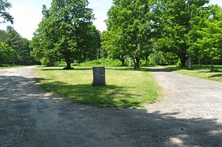
Dana was a town located in Worcester County, Massachusetts, United States. Dana was lost as a result of the formation of the Quabbin Reservoir.

The Sturbridge Common Historic District encompasses the historic center of Sturbridge, Massachusetts. Encompassing some 138 acres (56 ha), the district is focused around the town common, which was laid out when the town established in 1738. The district is roughly linear, extending along Main Street from its junction with Interstate 84 eastward to Hall Road. The district also extends for short distances along Haynes, Maple, and Charlton Streets. Although most of the properties in the district are residential, the institutional properties, including the 1838 Greek Revival Town Hall, the 1896 Joshua Hyde Library building, and the 1922 Federated Church. The oldest building in the district is the c. 1772 Publick House, a tavern which has dominated the south side of the district since its construction.

The Gardner Uptown Historic District is a historic district encompassing the former civic heart of Gardner, Massachusetts. The 65-acre (26 ha) area includes the old town common, an early cemetery, and a modest number of non-residential buildings among a larger number of houses. The area was the center of civic life from the incorporation of Gardner in 1785 until municipal functions were moved to West Gardner beginning in the late 1920s. The district was listed on the National Register of Historic Places in 1999.

The Harvard Center Historic District is a historic district encompassing the traditional village center of Harvard, Massachusetts, USA. The district is centered on the town common, a triangular grassy space bounded by Elm Street, Still River Road, and Ayer Road. The common is ringed by residences, civic and religious buildings, and a small commercial area. The common was laid out when the town was founded in 1732, and has grown, mainly in periods of growth at the late 18th and late 19th/early 20th centuries. Most of the village's buildings post-date 1831. The district was added to the National Register of Historic Places in 1997.

The Kingston Center Historic District is a historic district encompassing the center of Kingston, Massachusetts. The district is about 30 acres (12 ha) in size, and extends along Main Street between the First Parish Unitarian Church and the Mayflower Congregational Church, and for a short way along Green Street to the Evergreen Cemetery. At its center is the Training Green and Kingston Town Hall.

The Norwell Village Area Historic District encompasses the village center of Norwell, Massachusetts. It is centered on the town common, first laid out in the 1640s, around which a number of public buildings are located, and radiates away along Main, Central, West, River, and Dover Streets. There are 34 buildings in the district, predominantly residential and representing a cross-section of architectural styles from the 18th to the early 20th centuries. Prominent buildings include the 1830 First Parish Church, the 1874 Italianate-style James Library building, and the 1934 Colonial Revival Cushing Memorial Town Hall.
The Russell Corner Historic District of Princeton, Massachusetts encompasses a small 19th century commercial center that developed into a summer resort area by the early 20th century. Centered at the intersection of Merriam Road and Gregory Hill Road, the district includes fifteen contributing buildings on 124 acres (50 ha), which are predominantly residential in nature, and were mostly built before 1830. Some of the properties are found on East Princeton and Sterling Roads, and Bullock Lane. The district was listed on the National Register of Historic Places in 2006.

The Spencer Town Center Historic District encompasses the historic downtown of Spencer, Massachusetts. When first listed on the National Register of Historic Places in 1986, the district covered 250 acres (100 ha) centered on Main Street between High and North Streets. A major expansion, the East Main Street – Cherry Street Historic District, added 45 acres (18 ha) of a predominantly residential area east of the center. The district was expanded twice in 2003, adding residential areas along Grove, Prouty, Pleasant, High, and Main Streets, and industrial areas on Cherry, Wall, and Mechanic Streets, as well as Luther Hill Park. The main period of historic interest is the peak period of Spencer's industrial history in the last quarter of the 19th century, although there are a significant number of properties that predate this period.

The Sutton Center Historic District is a historic district encompassing the center of the village of Sutton, Massachusetts. The district, which covers 435 acres (176 ha), is centered on the junction of Boston Road, Singletary Avenue, and Uxbridge Road. Boston Road is a major east–west route through the town, and the other two roads run north–south through the village center. The Colombian building was built in 1957. A typically rural village center, its civic and institutional buildings are clustered near the intersection on its south side, in the general area of the town common. The town common and cemetery were laid out in 1719, after settlement of the township began in 1716. There are a few surviving houses that date to the middle of the 18th century or earlier; exact dates for most are uncertain. There are only a few institutional buildings: the 1829 Congregational Church, the 1983 Town Hall, built on the site of the town's first purpose-built town hall (1885), and Rufus Putnam Hall, an 1824 school building and Masonic lodge that now houses the local history museum. Only one commercial structure the 1839 Brick Block, stands in the village. There is also a historic animal pound, a rectangular stone structure used to pen stray livestock, which dates to the early days of the town.

The Town Hall Square Historic District is a historic district encompassing the center of Sandwich, Massachusetts. The original 54-acre (22 ha) district was visually centered on Sandwich Town Hall, Shawme Pond, and the reconstructed Dexter Grist Mill. When first listed on the National Register of Historic Places in 1975, it was roughly bounded by Main, Grove, Water Sts., and Tupper Rd. from Beale Ave. to MA 6A. In 2010 the district was expanded, adding another 170 acres (69 ha) and more than 150 contributing resources.

Mill River Historic District is a historic district encompassing the traditional center of government and a former industrial mill village along the Konkapot River in the village of Mill River in New Marlborough, Massachusetts. The district is roughly bounded by Main Street and River Church, Southfield, Clayton, School, and Hayes Hill Roads. It encompasses about 425 acres (172 ha), and contains mostly 19th century residential and civic buildings, as well as remnants of 19th century industrial activity.
The Colrain Center Historic District encompasses the historic center of Colrain, Massachusetts, a rural hill town in north-western Franklin County. The 30-acre (12 ha) district was listed on the National Register of Historic Places in 2006.

The New Salem Common Historic District encompasses the historic town center of New Salem, Massachusetts. Located on South Main Street, it includes the town common and most of its civic and institutional buildings. Most buildings in the district date to the 18th and 19th centuries. The district was listed on the National Register of Historic Places in 1978.

The Wendell Town Common Historic District encompasses the historic heart of the small town of Wendell, Massachusetts. Centered on a town common established in 1782, it includes a significant number of well preserved Greek Revival buildings. The district was listed on the National Register of Historic Places in 1992.

The Bedford Center Historic District encompasses the historic heart of the town of Bedford, Massachusetts. It extends along Great Road between Bacon and Concord Roads, and includes primarily residential areas on adjacent side streets. The area includes the town's main civic buildings, its first cemetery, and a diverse array of residential architecture spanning more than two centuries. The district was listed on the National Register of Historic Places in 1977; its boundaries were adjusted in 2014 and its period of significance extended.

The Common District encompasses the main civic center of Wakefield, Massachusetts. It is centered on the historic town common, just south of Lake Quannapowitt, which was laid in 1644, when it became the heart of Old Reading. The area was separated from Reading as South Reading in 1818, and renamed Wakefield in 1868. The 25 acre district includes the buildings that line the common on Common Street and Main Street, which include the town hall, public library, YMCA, post office, and several churches. It was listed on the National Register of Historic Places in 1990.

The Leverett Center Historic District is an expansive 467-acre (189 ha) historic district encompassing the historic heart of the rural community of Leverett in eastern Franklin County, Massachusetts. The district is focused on a two-mile stretch of Depot and Montague Roads, at whose center is the civic heart of the town. It includes the 1838 Greek Revival First Congregational Church, the town hall, whose present form was achieved in 1895 by raising the 1845 construction and building a first floor underneath it, and the Colonial Revival Field Memorial Library (1916). It also includes a town pound built c. 1822, and a number of 18th century residences. The district was listed on the National Register of Historic Places in 2008.

The West Village Historic District of Princeton, Massachusetts, encompasses the historic heart of its West Village. The 465-acre (188 ha) district abuts the Princeton Center Historic District to the east, and was listed on the National Register of Historic Places in 2009.

The Oxford Main Street Historic District is a national historic district encompassing the historic center of Oxford, Massachusetts. The 95-acre (38 ha) district extends along Main Street from Huguenot Street in the south to Front Street in the north. Its oldest buildings are residential houses built in the late 19th century, while most of the properties were built in the 19th century, with Greek Revival architecture predominating. The oldest commercial building, the John Wetherell Store, was built c. 1817, and now houses offices. The district includes four churches, including the 1793 Universalist church and 1829 First Congregational Church, and a number of municipal buildings, including the town hall, two schools, and the 1903 Classical Revival Charles Larned Memorial Library.

The Plainfield Center Historic District encompasses the historic rural village center of Plainfield, Massachusetts. The district is centered on a stretch of Main Street, between Church Lane and Central Street, and includes the town's oldest surviving houses, and its congregational church, set on the site of its first colonial-era meeting house, as well as the town hall (1847) and library (1925). The district was listed on the National Register of Historic Places in 2015.


