
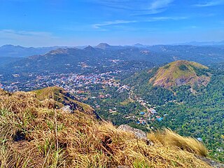
Thodupuzha is a municipal town located in Idukki district, Kerala, India, that covers an area of 35.43 km2 (13.68 sq mi). It lies on the banks of Thodupuzha river, which merges with the Kaliyar and Kothamangalam rivers at Muvattupuzha to form the Muvattupuzha river. Thodupuzha is 53 km (33 mi) from Kottayam, 75 km (47 mi) from Kattappana and 60 km (37 mi) south east of Kochi. Thodupuzha is 197 km (122 mi) from the state capital, Trivandrum. The geographical classification of the Thodupuzha Region is Malanad or Keezhmalanad.

Idukki is one of the 14 districts in the Indian state of Kerala. It is the largest district in Kerala and lies amid the Cardamom Hills of Western Ghats in Kerala. Idukki district contains two municipal towns - Kattappana and Thodupuzha, and five taluks.

Muvattupuzha is a town, municipality in the midlands directly to the east of Kochi in Ernakulam district, Kerala, India. It is located about 36 km (22 mi) from downtown Kochi, and is a growing urban centre in central Kerala. The town is also the starting point of the Muvattupuzhayar, which is a confluence formed by three rivers: the Thodupuzhayar, Kaliyar, and Kothayar.
Murickassery is a major market and educational centre in the Idukki district of Kerala state, South India. This is a village of migrant farmers and migrants has been developing as an important centre of Idukki. Various spice products provide the life blood for this village and market. Murickassery is situated in Vathikkudy Grama Panchayath.Cheruthony is the nearst town.

Kumily, also spelt as Kumaly is a revenue village and Gram Panchayat in the Idukki district of Kerala. It is a town in Cardamom Hills near Thekkady and Periyar Tiger Reserve. Kumily is a gateway town into Kerala from Tamil Nadu.
Kattappana is a municipal town in the Sahyadri of Kerala state, India. It is the main urban centre in the high ranges of Idukki district, situated about 2,788.71–2,952.76 feet (850.00–900.00 m) from sea level. It is the second city to become a municipality in Idukki District. It is a major commercial town and flourished with the boost in production of agriculture and spices.

The Main Eastern Highway is the lifeline of the high range townships of the Travancore region of Kerala state, India. It is also known as Punalur-Muvattupuzha Highway. Main Eastern Highway is categorized as State Highway - 08 of Kerala. It is the second longest State Highway of Kerala covering a distance of 153.6 km. The districts it passes through are Kollam, Pathanamthitta, Kottayam, Idukki and Ernakulam.

Ayyappancoil, also spelt Ayyappankovil is a village in newly formed Idukki taluk in Idukki district in the Indian state of Kerala. The place is popular for having a suspension bridge with a length of 200 meters and an old historic Sastha temple on the banks of Periyar river.

Elappara is a town in Idukki district in the Indian state of Kerala. It is one of the panchayaths in Peerumedu taluk. The area is marked by a cool climate as the region is situated at an elevation of more than 1,000 m (3,300 ft) above the sea level. Elappara is famous for its vast tea plantations.
Poopara is a village in Idukki district in the Indian state of Kerala. It is located in the cardamom-growing region of Kerala, and also houses a number of tea and coffee plantations. The place also intersects the Munnar - Kumily state highway (SH-19) and Kochi - Dhanushkodi national highway (NH-49). The Anayirankal reservoir is 4 km up the road from Poopara.
Rajakkad is a town in the Idukki district in the Indian state of Kerala situated in the Western Ghats.
Sulthankada is a village in the Idukki district of Kerala, India. It is located between Pampupara and Anakkara on Kumily - Munnar highway. This village includes tiny settlements - Chittampara, Keerimukku, Churuli Valavu, Puthumana Medu, Thenganal Kavala, Thaloda, etc. mostly covering cardamom and pepper plantations, pepper grows and paddy fields.
State Highway 33 is a State Highway in Kerala, India that starts in Thodupuzha and ends at Kumily road. The highway is 92.1 km long.
State Highway 43 is a State Highway in Kerala, India that starts in Muvattupuzha and ends in Theni Town. The highway is 105 km long. The Route Starts from Chali Bridge at Muvattupuzha Connecting to NH 49 towards Kothamangalam.
Kadassikkadavu is a village located on Munnar - Kumily state highway in Idukki district of Kerala, India. It is a part of Vandanmedu panchayath in Central Kerala Division. It is located 33 km (21 mi) south of the district headquarters at Painavu, 11 km (6.8 mi) from Kattappana and 154 km (96 mi) from the state capital of Thiruvananthapuram.
Kambilikandam is a village in Idukki district, Kerala state, India. Located 16 km from Adimaly, 30 km from Kattappana, 32 km from Munnar, 14 km from Thopramkudy and 27 km from Nedumkandam.
Kovilmala, locally known as Kozhimala, is a tribal settlement and a small village near Kattappana in the district of Idukki in Kerala state, India. It is the only existing tribal kingdom in South India which falls under the Kanchiyar grama panchayath of Idukki tehsil. The Kingdom consists of namely four divisions such as 'Thekkottu Kattu Rajyam', 'Nadukkuda Kattu Rajyam', 'Athal Orupuram' and 'Chenkanattu Mala'. Goddess Madhura Minakshi of famed Madura Temple in Tamil Nadu is their Kuladevatha.
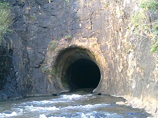
Anchuruli, also spelled Anjuruli, is a popular tourist destination located in Kanchiyar panchayat in Idukki district, Kerala state, India. Anchuruli is famous for the 5.5 km (3.4 mi) long circular tunnel that carries water from Erattayar dam to Idukki reservoir.
Marykulam is a village in Udumbanchola taluk of Idukki district in the Indian state of Kerala. It comes under the administration of Ayyappancoil panchayat. It is situated 15 km (9.3 mi) from Kattappana, 25 km (16 mi) from Kumily and 3 km (1.9 mi) from Upputhara.

Erattayar is a village in Udumbanchola taluk of Idukki district in the Indian state of Kerala. It is the administrative centre of Erattayar panchayat which belongs to Kattappana block panchayat.

