
The West Newton Village Center Historic District encompasses the heart of the village of West Newton, in the city of Newton, Massachusetts in the United States. It extends along Washington Street between Lucas Court in the west and Davis Court in the east, and includes a few properties on immediately adjacent side streets, including Watertown Street and Waltham Street. The village is the second-largest of Newton's commercial centers and is the best-preserved of its late 19th and early 20th century village centers. The district was listed on the National Register of Historic Places in 1990.

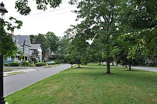
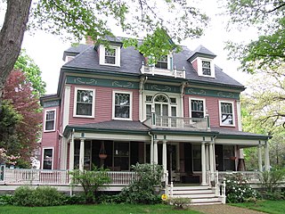
The West Newton Hill NR Historic District is a residential National Register historic district in the village of West Newton, in the city of Newton, Massachusetts in the United States. It is composed of a cohesive collection of spacious houses built in the second half of the 19th century, representing the development of the West Newton area as a fashionable railroad suburb. The district was listed on the National Register of Historic Places in 1986.
The Washington Park Historic District is a historic district in the village of Newtonville, in Newton, Massachusetts. It includes the following properties, dating to between 1870 and 1900: 4 to 97 Washington Park plus 5 and 15 Park Place. The focal point of the district is the city park which is located in the median of the street of the same name. On March 12, 2008, it was added to the National Register of Historic Places.

The Moreland Street Historic District is a historic district roughly bounded by Kearsarge, Blue Hill Avenues, and Warren, Waverly, and Winthrop Streets in the Roxbury neighborhood of Boston, Massachusetts. It encompasses 63 acres (25 ha) of predominantly residential urban streetscape, which was developed between about 1840 and 1920. Housing types represent a cross-section of architectural styles from the period, including Second Empire, Italianate, and Queen Anne style. It is a fairly well-preserved grouping in an area where many sections have been negatively affected by urban blight and redevelopment. One notable house is at 130 Warren Street: it is the only house in the district built out of Roxbury puddingstone. That building is currently under study as a pending landmark for the Boston Landmarks Commission.

The East Cambridge Historic District encompasses the historic center of East Cambridge, Massachusetts. It includes the major buildings that were built to house county services for Middlesex County beginning in the 1810s, and a cluster of largely vernacular Greek Revival worker housing located west of the county complex on Otis, Thorndike, Spring, and Sciarappa Streets. The district was listed on the National Register of Historic Places in 1983.

The Prospect Hill Historic District encompasses a large residential area in the Willimantic section of Windham, Connecticut. Located north of the Main Street commercial district, it was developed between about 1865 and 1930, and is one of the state's largest historic districts, with more than 800 contributing buildings. It is roughly bounded by Valley, Jackson, Bolivia, Washburn, Windham, and High Streets, and contains one of the state's largest single concentrations of Victorian-era residential architecture. It was listed on the National Register of Historic Places in 2003.

The Newton Theological Institution Historic District is an historic district in the village of Newton Centre in Newton, Massachusetts. It encompasses not only the campus of the Newton Theological Institution, now known as the Andover Newton Theological School, but also a cluster of fashionable 19th century houses north of the campus, on Herrick Road and Chase and Cypress Streets. The school was the first outside educational institution in Newton. The district was listed on the National Register of Historic Places in 1986.
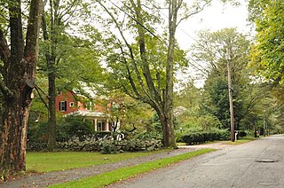
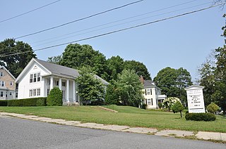
The Silver Hill Historic District encompasses the first major residential subdivision of Weston, Massachusetts. It includes 79 buildings on Silver Hill and Westland Roads, and Merriam Street. The area of Silver Hill and Westland Roads was formally laid out in 1905, while Merriam Street is a very old country road which had seen some development in the 1890s. The houses in the district are predominantly Colonial Revival and Queen Anne in their styling, a relative rarity in Weston although common in other Boston suburbs. The district was added to the National Register of Historic Places in 2004.

16 Mineral Street in Reading, Massachusetts is a well-preserved Second Empire cottage. It was built c. 1874 and probably moved to its present location not long afterward, during a building boom in that part of the town. It was listed on the National Register of Historic Places in 1984.

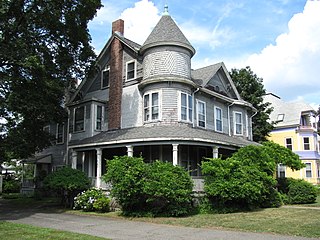
The Firth–Glengarry Historic District encompasses a residential area of Winchester, Massachusetts consisting of well-preserved high quality houses built mainly between 1880 and 1900. The district lies between Wildwood Street and Wedge Pond, and includes properties on Pine Street, Glengarry Road, Grassmere Avenue, Dix Street, and Wildwood Street; houses on Curtis Street and Curtis Circle, are excluded from the district. Much of the area was laid out by developer William Firth, and many of its houses were designed by Boston architect Robert Coit. The 13.44-acre (5.44 ha) district was listed on the National Register of Historic Places in 1989.

The Yale Avenue Historic District is a residential historic district near the center of Wakefield, Massachusetts. It encompasses eight residential properties, all but one of which were developed in the 1860s and 1870s, after the arrival of the railroad in town. These properties were built primarily for Boston businessmen, and mark the start of Wakefield's transition to a suburb.

The Nobility Hill Historic District is a residential historic district roughly bounded by Chestnut and Maple Streets and Cedar Avenue in Stoneham, Massachusetts. The district includes a number of high quality houses representing a cross section of fashionable housing built between 1860 and 1920. It was added to the National Register of Historic Places in 1990.

The House at 9 White Avenue in Wakefield, Massachusetts is a well-preserved transitional Queen Anne/Colonial Revival house. Built about 1903, it was listed on the National Register of Historic Places in 1989.
The Crystal Lake and Pleasant Street Historic District encompasses a streetcar suburban residential subdivision developed between 1860 and 1895 in Newton, Massachusetts. The district roughly bounded by the Sudbury Aqueduct, Pleasant Street, Lake Avenue, Webster Court, and Crystal Street. The subdivision was laid out in the 1850s after the Boston and Charles Railroad line was extended through Newton from Brookline. The district was listed on the National Register of Historic Places in 1986.

The Farlow and Kenrick Parks Historic District is a predominantly residential historic district in the Newton Corner area of Newton, Massachusetts. The district is roughly triangular in shape, and is bounded on the north by the Massachusetts Turnpike, Park Street to the east, and Franklin and Newtonville Avenues to the west. It is roughly bisected by Church Street, and is named for two parks that are significant focal elements of the district. Kenrick Park is a small lozenge-shaped park at the southern tip of the district designed by Alexander Wadsworth; it was laid out at the request of William Kenrick, a horticulturalist whose c. 1822 Federal style house was moved to the area after the park was completed. Farlow Park is a larger rectangular park, in the district's northwest, which was established by a gift from John Farlow. It is landscaped in a manner similar to the Boston Public Garden, with specimen trees and an artificial pond with bridge.

The Hyde Avenue Historic District is a residential historic district encompassing the stylistic range of houses being built in the Newton Corner area of Newton, Massachusetts in the 1880s. It includes the five houses at 36, 42, 52, 59, and 62 Hyde Avenue, The district was added to the National Register of Historic Places in 1986.
The Newton Highlands Historic District encompasses the historic heart of the village of Newton Highlands in Newton, Massachusetts. When it was added to the National Register of Historic Places in 1986, the district extended along Lincoln Street from Woodward to Hartford Streets, and included blocks of Bowdoin, Erie and Hartford Streets south of Lincoln Street. The district was enlarged in 1990 to include the cluster of commercial buildings on Lincoln Street between Hartford and Walnut Streets.

The Sumner and Gibbs Streets Historic District is a residential historic district encompassing a cohesive collection of houses representing styles common in the Newton Centre area of Newton, Massachusetts during its first period of growth. It includes houses along Sumner Street, between Cotswold Terrace and Willow Street, and the adjacent house at 184 Gibbs Street. The houses were built between 1865 and 1899, and are predominantly in the Queen Anne and Colonial Revival styles. The district was listed on the National Register of Historic Places in 1986.

The Downtown North Historic District is a 19-acre (7.7 ha) historic district in Hartford, Connecticut. It is a predominantly residential area located around Main Street and High Street north of I-84 and south of the Amtrak railroad tracks. Its apartment blocks, houses, schools and churches, built up mainly in the late 19th and early 20th centuries as part of an expansion of the city's urban core. It includes the 130-foot (40 m) Keney Tower. The area was listed on the National Register of Historic Places in 2004.
The West Main Street Historic District of Marlborough, Massachusetts encompasses a residential area west of the city center. It extends along West Main Street from Mechanic Street to Gibbon Street, along Pleasant Street from West Main to Lincoln Street, and also includes short pieces of Witherbee and Winthrop Streets abutting West Main. Most of the buildings in the district are houses built between 1820 and 1930, the period of the city's growth as an industrial center. The 15-acre (6.1 ha) district includes 77 properties, all but two of which contribute to its historic significance. The district was listed on the National Register of Historic Places in 2001.


