
The Kuban oblast was a province (oblast) of the Caucasus Viceroyalty of the Russian Empire. It roughly corresponded to most of the Kuban and Circassia regions. It was created in 1860 out of Kuban Cossack territories that had once been part of the Crimean Khanate and the land of the Circassians. It was dissolved upon the assumption of supreme authority by the Kuban Rada in 1917 and the independence of the Kuban People's Republic in 1918. Its capital was the city of Yekaterinodar.
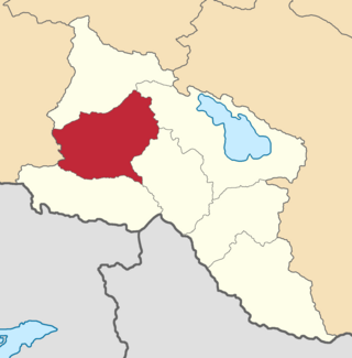
The Etchmiadzin uezd was a county (uezd) of the Erivan Governorate of the Caucasus Viceroyalty of the Russian Empire. The uezd bordered the Alexandropol uezd to the north, the Nor Bayazet uezd to the east, Erivan uezd to the north, the Surmalu uezd to the south, and the Kars Oblast to the west. It included all of the Armavir Province and most of the Aragatsotn Province of present-day Armenia. The administrative centre of the county was Vagorshapat (Vagharshapat), also referred to as Etchmiadzin—the administrative capital of the Armenian Apostolic Church.

The Telavi uezd was a county (uezd) of the Tiflis Governorate of the Caucasus Viceroyalty of the Russian Empire, and then of Democratic Republic of Georgia, with its administrative center in Telavi. The area of the county roughly corresponded to the contemporary Samtskhe-Javakheti region of Georgia.

The Tiflis uezd was a county (uezd) of the Tiflis Governorate of the Caucasus Viceroyalty of the Russian Empire, and then of Democratic Republic of Georgia, with its administrative centre in Tiflis. The area of the uezd roughly corresponded to the contemporary Kvemo Kartli region of Georgia. The district bordered the Telavi uezd to the northeast, the Tionety and Dusheti uezds to the north, the Gori uezd to the northwest, the Borchaly uezd to the west, the Kazakh uezd of the Elizavetpol Governorate to the south, and the Signakh uezd to the east.

The Batumi okrug was a district (okrug) of the Batum Oblast of the Russian Empire existing between 1878 and 1918. The district was eponymously named for its administrative center, the town of Batum, now part of Adjara within Georgia. The okrug bordered with the Artvin okrug in the south, the Ardahan okrug of the Kars Oblast to the southeast, the Tiflis Governorate to the northeast, the Kutaisi Governorate to the north, and the Trebizond Vilayet of the Ottoman Empire to the west.
The Batalpashinsky otdel was a Cossack district of the Kuban oblast of the Caucasus Viceroyalty of the Russian Empire. It bordered the Stavropol Governorate to the north, the Labinsky and Maykopsky otdels to the west, the Sochi and Sukhumi okrugs to the south, and the Terek Oblast to the east. The area of the Batalpashinsky otdel included most of the contemporary Karachay-Cherkessia region of Russia. The administrative capital was the city of Batalpashinskaya.
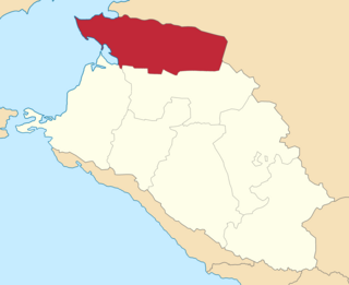
The Yeysky otdel was a Cossack district of the Kuban oblast of the Caucasus Viceroyalty of the Russian Empire. It bordered the Don Host Oblast to the north, the Black Sea to the west, the Kavkazsky otdel to the south, and the Stavropol Governorate to the east. The area of the Yeysky otdel included most of the contemporary Krasnodar Krai region of Russia. The administrative capital was the city of Umanskaya.

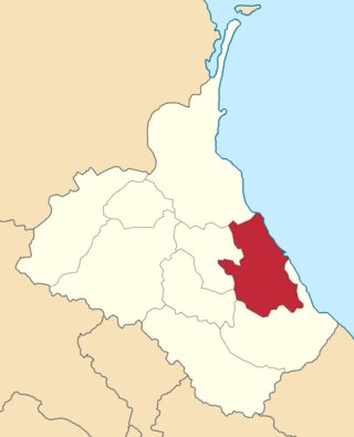
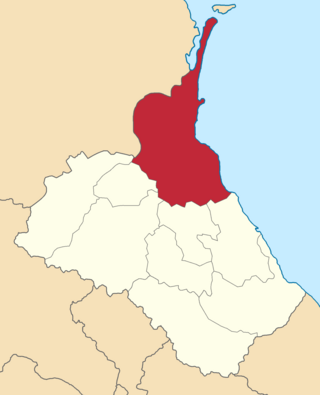
The Yekaterinodarsky otdel was a Cossack district of the Kuban oblast of the Caucasus Viceroyalty of the Russian Empire. It bordered the Kavkazsky otdel to the north, the Tamansky otdel to the west, the Black Sea Governorate to the south, and the Maykopsky otdel to the east. The area of the Yekaterinodar otdel mostly corresponded to the contemporary Krasnodar Krai region of Russia. The district was eponymously named for its administrative center, Yekaterinodar.
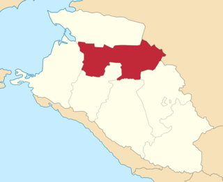
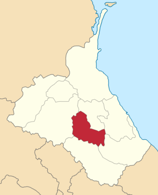
The Kavkazsky otdel was a Cossack district of the Kuban oblast of the Caucasus Viceroyalty of the Russian Empire. It bordered the Yeysky otdel to the north, the Tamansky otdel to the west, the Yekaterinodarsky and Maykopsky otdels to the south, and the Stavropol Governorate to the east. The area of the Kavkazsky otdel mostly corresponded to the contemporary Krasnodar Krai region of the Russian Federation. The district was eponymously named for its administrative center, Kavkazskaya.
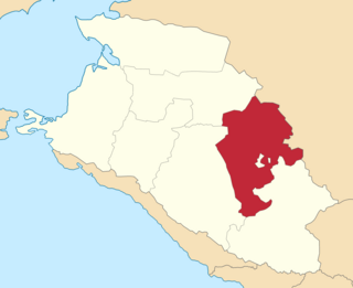
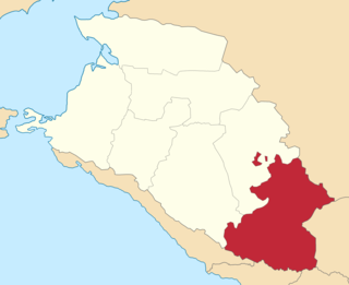
The Labinsky otdel was a Cossack district of the Kuban oblast of the Caucasus Viceroyalty of the Russian Empire. It bordered the Kavkazsky otdel to the north, the Maykopsky otdel to the west, the Batalpashinsky otdel to the south, and the Stavropol Governorate to the east. The area of the Labinsky otdel mostly corresponded to the contemporary Krasnodar Krai region of the Russian Federation. The administrative capital of the district was the city of Armavir.

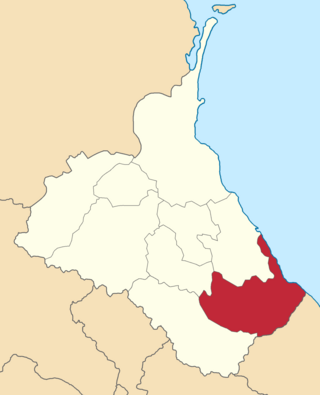
The Maykopsky otdel was a district of the Kuban oblast of the Caucasus Viceroyalty of the Russian Empire. It bordered the Kavkazsky otdel to the north, the Yekaterinodarsky otdel to the west, the Black Sea Governorate to the south, and the Labinsky and Batalpashinsky otdels to the east. The area of the Maykopsky otdel mostly corresponded to Adygea within Russia. The district was eponymously named for its administrative center, Maykop.

The Tamansky otdel, known before 1910 as the Temryuksky otdel, was a Cossack district of the Kuban oblast of the Caucasus Viceroyalty of the Russian Empire. It bordered the Yeysky otdel to the north, the Black Sea to the west, the Black Sea Governorate to the south, and the Kavkazsky and Yekaterinodarsky otdels to the east. The area of the Tamansky otdel mostly corresponded to the contemporary Krasnodar Krai region of Russia. The district's administrative capital was the stanitsa of Slavyanskaya (Slavyansk-na-Kubani).
The Kazikumukhskiy okrug was a district (okrug) of the Dagestan Oblast of the Caucasus Viceroyalty of the Russian Empire. The area of the Kazikumukhskiy okrug is included in contemporary Dagestan of the Russian Federation. The district's administrative centre was Kumukh.
The Kaytago-Tabasaranskiy okrug was a district (okrug) of the Dagestan Oblast of the Caucasus Viceroyalty of the Russian Empire. The area of the Kaytago-Tabasaranskiy okrug is included in contemporary Dagestan of the Russian Federation. The district's administrative centre was Madzhalis.
The Kyurinskiy okrug was a district (okrug) of the Dagestan Oblast of the Caucasus Viceroyalty of the Russian Empire. The area of the Kyurinskiy okrug is included in contemporary Dagestan of the Russian Federation. The district's administrative centre was Kasumkent.
The Temir-Khan-Shurinskiy okrug was a district (okrug) of the Dagestan Oblast of the Caucasus Viceroyalty of the Russian Empire. The area of the Temir-Khan-Shurinskiy okrug is included in contemporary Dagestan of the Russian Federation. The district's administrative centre was Temir-Khan-Shura.

The Sunzhensky otdel was a Cossack district of the Terek oblast of the Caucasus Viceroyalty of the Russian Empire. The area of the Sunzhensky otdel makes up part of the North Caucasian Federal District of Russia.

The Vladikavkazsky okrug was a district (okrug) of the Terek Oblast of the Caucasus Viceroyalty of the Russian Empire. The area of the Vladikavkazsky okrug made up part of the North Caucasian Federal District of Russia. The district was eponymously named for its administrative centre, Vladikavkaz.

The Kizlyarsky otdel was a Cossack district of the Terek oblast of the Caucasus Viceroyalty of the Russian Empire. The area of the Kizlyarsky otdel makes up part of the North Caucasian Federal District of Russia. The district was eponymously named for its administrative center, Kizlyar.

The Mozdoksky otdel was a Cossack district of the Terek oblast of the Caucasus Viceroyalty of the Russian Empire. The area of the Mozdoksky otdel makes up part of the North Caucasian Federal District of Russia. The district was eponymously named for its administrative center, Mozdok.
