
A fire lookout tower, fire tower or lookout tower, provides housing and protection for a person known as a "fire lookout" whose duty it is to search for wildfires in the wilderness. The fire lookout tower is a small building, usually located on the summit of a mountain or other high vantage point, in order to maximize the viewing distance and range, known as view shed. From this vantage point the fire lookout can see smoke that may develop, determine the location by using a device known as an Osborne Fire Finder, and call fire suppression personnel to the fire. Lookouts also report weather changes and plot the location of lightning strikes during storms. The location of the strike is monitored for a period of days after in case of ignition.

The Mogollon Baldy Lookout Cabin, in Gila National Forest on Mogollon Baldy peak, in New Mexico, was built in 1923. It was listed on the National Register of Historic Places in 1988.

The Watchman Lookout Station No. 168 is one of two fire lookout towers in Crater Lake National Park in southern Oregon. For many years, National Park Service personnel used the lookout to watch for wildfires during the summer months. It is also a common hiking destination because of its views of Crater Lake and the surrounding area. The building is unusual because it serves the dual purpose of fire lookout and museum. The Watchman Lookout Station is listed on the National Register of Historic Places.

Wood End Light Lookout Station is a historic lighthouse, located at the southwest end of Long Point in Provincetown, Massachusetts. It is located at Wood End, near the southernmost extent of the Provincetown Spit, and acts as a navigational aid to vessels on their approach to Provincetown Harbor. The Long Point Light Station, further down the peninsula at the tip of Long Point is an identical design and completed in 1875, three years after Wood End Light.

The Shadow Mountain Lookout, also known as the Shadow Mountain Patrol Cabin, was built in Rocky Mountain National Park in 1932, to the design of the National Park Service San Francisco Landscape Architecture Division. It was regarded as one of the best National Park Service Rustic buildings in the national park system. It is now the only fire lookout surviving in Rocky Mountain National Park. Three other lookouts, now gone, were located at Twin Sisters Peak, the north fork of the Thompson River and near Long's Peak. The lookout was built by Civilian Conservation Corps labor.

The Unity Ranger Station is a United States Forest Service compound consisting of five buildings and a lookout tower in the Wallowa-Whitman National Forest of northeastern Oregon. It was previously the administrative headquarters for the Unity Ranger District. It is located in the small unincorporated community of Unity, Oregon. The historic structures were built in the rustic style by the Civilian Conservation Corps between 1936 and 1938. Today, the ranger station is only used during the summer months to house Forest Service fire crews. The ranger station is listed on the National Register of Historic Places.

Suntop Lookout is located on Suntop Mountain in Mount Baker-Snoqualmie National Forest in central Washington, USA. The fire lookout is at an elevation of about 5,270 feet (1,610 m) overlooking the valleys of the White River and Huckleberry Creek just to the north of Mount Rainier National Park. Built to standard U.S. Forest Service plans, the one-story ground-level lookout measures fourteen by fourteen feet. The frame structure is capped by a pyramidal roof, and features large windows on all four sides with pivoting shutters that act as sunshades.

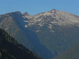
The Tolmie Peak Fire Lookout is one of four fire lookout stations built in Mount Rainier National Park by the United States National Park Service (NPS) between 1932 and 1934. The two-story structure houses a lookout station on the upper level and storage at ground level. The design was prepared under the supervision of Edwin A. Nickel of the NPS Branch of Plans and Designs. The newly completed structure lost its roof to a windstorm and had to be repaired. It is secured against strong winds by cables attached to deadmen. The wood frame structure is used as a visitor contact point on weekends.

The Shriner Peak Fire Lookout is a fire lookout tower in Mount Rainier National Park. Built in 1932 to a standard design by the National Park Service Branch of Plans and Designs, the wood-frame lookout features a ground-floor storage room and an upper-level lookout and living space with windows on all four sides. A balcony extended around the perimeter of the upper level. The Shriner Peak Lookout is one of four surviving lookout stations in the park.

The Dodger Point Fire Lookout was built in 1933 in Olympic National Park as a fire observation station. The single-story frame structure is located on the peak of Dodger Point above the timber line at an elevation of 5,753 feet (1,754 m). Measuring 14 feet (4.3 m) by 14 feet (4.3 m), it is clad in wood clapboards and has a simple pitched roof covered with wood shakes. Large windows on all four sides are covered by awning-style wood shutters. It was built by the U.S. Forest Service in what was at the time Olympic National Forest, possibly with assistance from the Civilian Conservation Corps. During World War II, the lookout was used as an Aircraft Warning Service station. Dodger Point and Pyramid Peak Lookout are the only such stations remaining in Olympic National Park out of thirteen constructed.

The Enchanted Valley Chalet is a backcountry lodge in Olympic National Park. The chalet was built in 1931 by Tom E. Criswell, his son Glen and the Olson family of Quinault whose Olympic Recreation Company operated it as a destination lodge deep up the Quinault River Valley, about 13 miles (21 km) from the nearest road access. Under the Olsons' ownership through the 1930s, and for decades under the National Park Service, the chalet has endured as a destination in its own right. It was a popular destination for hikers and horse tours through the 1940s. In 1943, the chalet was closed as an accommodation. It was used for a short period as an Aircraft Warning Service station during World War II, watching for Japanese airplanes. It did not reopen until 1953, after the National Park Service had purchased the Olympic Recreation Company's holdings in 1951, having purchased the Chalet itself in 1939. After a period of neglect, the chalet was restored in 1983-84. It was one of four such accommodations built by the Olympic Recreation Company and the Olympic Chalet Company; Low Divide Chalet, Nine Mile Shelter, Graves Creek Inn and the Enchanted Valley Chalet. Of the four, only the Enchanted Valley Chalet and the bathhouse at Low Divide remain.

The Big Springs Lookout Tower is a fire lookout tower in Kaibab National Forest near Big Springs, Arizona. The tower was built in 1934 for the U.S. Forest Service by contractors from Kanab, Utah. The steel tower is 100 feet (30 m) tall and features a 7-foot (2.1 m) square cab at the top. A wood frame cabin is located near the base of the tower; the cabin was built in 1959 to replace an older log cabin.

The Chief Mountain Border Station and Quarters is a customs station on the Canada–United States border in Glacier County, Montana. Located on Montana Highway 17, the station is operated seasonally, primarily for tourist traffic between Glacier National Park in Montana and Waterton Lakes National Park in Alberta. The station is named after Chief Mountain, a prominent peak in the vicinity. The station is owned by the General Services Administration and operated by U.S. Customs and Border Protection, and is located within the boundaries of Glacier National Park. The station is a notable example of the National Park Service Rustic style and is listed on the National Register of Historic Places.

The Copper Mountain Fire Lookout was built in 1934 in what was then the Glacier Ranger district of Mount Baker National Forest. The cabin-like wood frame lookout is a frame cabin with large windows on each side protected by an awning-style shutter. A shingled gable roof with prominent lightning rods covers the cabin. The lookout measures 14.25 feet (4.34 m) by 14.25 feet (4.34 m) square. During the winter of 1943 the lookout was manned by the Aircraft Warning Service, watching for enemy aircraft. It is one of three lookouts remaining in North Cascades National Park from the Forest Service administration.

The Prospect Peak Fire Lookout is a fire lookout station located on Prospect Peak in Lassen Volcanic National Park, near the city of Mineral, California. The lookout, which was built circa 1912, is one of the oldest extant U.S. Forest Service fire lookouts in the United States. The wood frame building is square with a pyramidal roof; its walls are mostly composed of tall windows, with shiplap siding below the windows and on the roof. This design was a standard design used by U.S. Forest Service fire lookouts at the time, and several of the other contemporary lookouts in the national park also used this style of construction. The lookout is likely now the only surviving station with this design. Though the station was ultimately abandoned and has lost its original windows and roof shingles, it is otherwise intact.

Gifford Woods State Park is a state park located at the base of Pico Peak in Killington, Vermont. The wooded park provides camping, picnic, and fishing facilities, and has hiking trails, including a portion of the Appalachian Trail. It preserves an area of old-growth forest that has been designated a National Natural Landmark, and is accessible via an interpretive trail. The park was established in 1931. Part of it is listed on the National Register of Historic Places, for facilities developed by the Civilian Conservation Corps in the 1930s.
Hidden Lake Peaks is series of peaks with a maximum elevation of 7,088 feet that are located in the North Cascades, in Skagit County of Washington state. The peaks extend three miles southwest from the nearest higher peak called The Triad. Situated on the western boundary of North Cascades National Park, Hidden Lake Peaks are positioned west of the crest of the Cascade Range, approximately ten miles east of the town of Marblemount. The popular subsidiary peak, Hidden Lake Lookout (6890 ft), lies a half mile to the southwest of the highest summit. The mountain's name is taken from its proximity to Hidden Lake which lies in a cirque below the east aspect of these two main peaks. Precipitation runoff from Hidden Lake Peaks drains into Cascade River which is a tributary of the Skagit River.

The Green Mountain Lookout is a historic fire lookout tower located at the summit of Green Mountain in the Glacier Peak Wilderness and the Mount Baker-Snoqualmie National Forest in Snohomish County, Washington. The single-story wood-frame structure measures 14 by 14 feet and was built according to a standard National Forest Service design in 1933 by the Civilian Conservation Corps. The structure includes an exterior catwalk and a cable anchor system to protect from strong winds.

Cone Peak is the second highest mountain in the Santa Lucia Range in the Ventana Wilderness of the Los Padres National Forest. It rises nearly a vertical mile only 3 miles (4.8 km) from the coast as the crow flies. This is one of the steepest gradients from ocean to summit in the contiguous United States. The average gradient from sea level to summit is around 33%, which is steeper than the average gradient from Owens Valley to the summit of Mount Whitney. Near the mountain summit, the oak woodland and chaparral transitions to a pine forest with a few rare Santa Lucia Firs. Junipero Serra Peak at 5,865 feet (1,788 m) is the highest peak in the coastal region.


