The Olympic Peninsula is a large arm of land in western Washington that lies across Puget Sound from Seattle, and contains Olympic National Park. It is bounded on the west by the Pacific Ocean, the north by the Strait of Juan de Fuca, and the east by Hood Canal. Cape Alava, the westernmost point in the contiguous United States, and Cape Flattery, the northwesternmost point, are on the peninsula. Comprising about 3,600 square miles (9,300 km2), the Olympic Peninsula contained many of the last unexplored places in the contiguous United States. It remained largely unmapped until Arthur Dodwell and Theodore Rixon mapped most of its topography and timber resources between 1898 and 1900.

The BC Forest Discovery Centre, located in Duncan, chronicles the history of logging in British Columbia, Canada. It is a 100-acre (40 ha) site with 2.5 km of operational 3 ft narrow gauge railway.
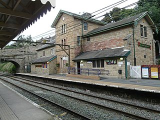
Broadbottom railway station serves the village of Broadbottom in Greater Manchester, England. It is on the Manchester-Glossop Line, 10 miles (16 km) east of Manchester Piccadilly. It was opened by the Sheffield, Ashton-Under-Lyne and Manchester Railway in 1842. It was renamed "Mottram" in 1845, but has since reverted to its original name.

Mount Hebo Air Force Station is a closed United States Air Force General Surveillance Radar station. It is located 5.2 miles (8.4 km) east-southeast of Hebo, Oregon, located at the top of 3,154-foot (961 m) Mount Hebo. It was closed in 1980.
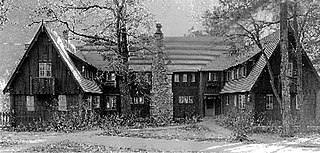
The Rangers' Club is a building in Yosemite Valley in Yosemite National Park that was donated by the independently wealthy first director of the National Park Service, Stephen Tyng Mather. He intended it to be used by the newly hired park rangers who were taking over from the departing army troops. He specifically intended it to blend into the natural environment. Its use of rustic stylings was part of a trend to the use of rustic design and natural materials in Park Service buildings until the 1940s.
Otter National Forest was established by the U.S. Forest Service in Montana on March 2, 1907, with 123,779 acres (500.92 km2). On July 1, 1908, the name was changed to Custer National Forest.
Barnes Point is an ancient landslide delta that juts out into Lake Crescent in Clallam County, Washington. As one of the few areas of relatively flat ground near Lake Crescent, it hosts Lake Crescent Lodge, the Storm King Ranger Station of Olympic National Park, as well as several private homes. It also contains the trails which access Mount Storm King, Marymere Falls, and Barnes Creek. Barnes Creek flows through an old-growth forest, providing spawning habitat for the endemic Crescenti cutthroat trout.

The Geyser Valley trail in Olympic National Park is an area along the Elwha River between Rica Canyon and the Grand Canyon of the Elwha, where many homesteaders tried to eke out a living in the late 19th and early 20th centuries. Today, this trail allows hikers to visit several interesting sites, as well as, providing several loops of different lengths.

The Rand Ranger Station is a Bureau of Land Management compound consisting of eight historic buildings located in the Rogue River-Siskiyou National Forest in southwest Oregon. It was built by the United States Forest Service and the Civilian Conservation Corps as a district ranger station for the Galice Ranger District. The ranger station property was transferred to the Bureau of Land Management in 1970. Today, the ranger station office serves as a visitor center. The Rand Ranger Station is listed on the National Register of Historic Places.

The Tiller Ranger Station is a United States Forest Service compound consisting of twenty-seven buildings in Oregon’s Umpqua National Forest. Over the years, it has been the administrative headquarters for five ranger districts. It is located in the small unincorporated community of Tiller, Oregon, United States. The historic structures were built in the rustic style by the Civilian Conservation Corps between 1935 and 1942. Today, the ranger station is the headquarters for the Tiller Ranger District, and is listed on the National Register of Historic Places.

The Unity Ranger Station is a United States Forest Service compound consisting of five buildings and a lookout tower in the Wallowa-Whitman National Forest of northeastern Oregon. It was previously the administrative headquarters for the Unity Ranger District. It is located in the small unincorporated community of Unity, Oregon. The historic structures were built in the rustic style by the Civilian Conservation Corps between 1936 and 1938. Today, the ranger station is only used during the summer months to house Forest Service fire crews. The ranger station is listed on the National Register of Historic Places.

The Lower Elwha Klallam Tribe is a federally recognized Native American nation in the Pacific Northwest of the United States. The tribe is part of the larger Klallam culture, part of the Coast Salish peoples.
The Olympic National Park Headquarters Historic District overlooks Port Angeles, Washington from Peabody Heights, consisting of 6 contributing buildings built in 1940–44, 8 contributing structures and 17 non-contributing properties that act as the administrative headquarters for Olympic National Park. The contributing structures were built using locally obtained native materials in a late interpretation of the National Park Service Rustic style. Native landscaping enhances the site. Much of the work was carried out by Public Works Administration and Civilian Conservation Corps workers.

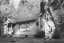
The Graves Creek Ranger Station is a small historic district in Olympic National Park, Washington, USA. It includes the first administrative buildings to be built by the National Park Service in the newly designated park. The district comprises two buildings built in 1939-41 by the National Park Service in the Graves Creek region of the western park. Labor from the Civilian Conservation Corps and the Public Works Administration was used for both the ranger station residence and the garage-woodshed, as well as for a generator building that no longer stands. The 1939 ranger station residence is a one-story frame structure, clad in cedar shingles. The garage is of similar construction, built in 1941. Both structures are examples of the late National Park Service Rustic style, featuring broad shingle courses and deep eaves.

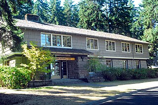
Leavenworth Ranger Station, also known as the Wenatchee River Ranger District, in Leavenworth, Washington was built during 1937-38 by the Civilian Conservation Corps. It was designed by the United States Forest Service's Region 6 USDA Forest Svce. Architecture Group in Rustic architecture. The listing includes nine contributing buildings on a 9.9-acre (4.0 ha) area.
The Elkhorn Guard Station, also known as the Elkhorn Ranger Station, comprises four buildings in the backcountry of Olympic National Park, Washington. The station was built by the U.S. Forest Service between 1930 and 1934, before the establishment of the national park, when the lands were part of Olympic National Forest (USFS). The structures were designed in the Forest Service's interpretation of the National Park Service rustic style, using native materials and construction techniques. The complex was built using labor from the Public Works Administration and the Civilian Conservation Corps. The Elkhorn Guard Station is one of five surviving USFS-built guard stations.

The Lake of the Woods Ranger Station is a United States Forest Service compound consisting of eight buildings overlooking Lake of the Woods in the Fremont-Winema National Forests of southern Oregon. All of the ranger station structures were built by the Civilian Conservation Corps between 1937 and 1939. Today, the compound serves as a Forest Service work center, and the old ranger station office is a visitor center. The ranger station is listed on the National Register of Historic Places.

The Bergland Administrative Site, also known as the Bergland Ranger Station, is a government administrative complex consisting of six buildings located along M-28 in Bergland, Michigan. It was listed on the National Register of Historic Places in 2005, and currently houses the Bergland Cultural & Heritage Center and The Bergland/Matchwood Historical Society Museum.
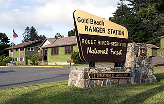
The Gold Beach Ranger Station was built at Gold Beach, Oregon in Siskiyou National Forest in 1936 by the Civilian Conservation Corps (CCC). The ranger station comprises several structures that typify the U.S. Forest Service's design style of the time.

The Cold Meadows Guard Station is a ranger station located northeast of McCall, Idaho in the Frank Church-River of No Return Wilderness and the Payette National Forest. It was listed on the National Register of Historic Places in 1994.