
Sunderland is a port city in Tyne and Wear, England. It is a port at the mouth of the River Wear on the North Sea, approximately 10 miles (16 km) south-east of Newcastle upon Tyne. The built-up area had a population of 168,277 at the 2021 census, making it the second largest settlement in North East England after Newcastle. It is the administrative centre of the metropolitan borough of the same name.

The Tyne Bridge is a through arch bridge over the River Tyne in North East England, linking Newcastle upon Tyne and Gateshead. The bridge was designed by the engineering firm Mott, Hay and Anderson, who later designed the Forth Road Bridge, and was built by Dorman Long and Co. of Middlesbrough. The bridge was officially opened on 10 October 1928 by King George V and has since become a defining symbol of Tyneside. It is ranked as the tenth tallest structure in Newcastle.

The High Level Bridge is a road and railway bridge spanning the River Tyne between Newcastle upon Tyne and Gateshead in North East England. It was built by the Hawks family from 5,050 tons of iron. George Hawks, Mayor of Gateshead, drove in the last key of the structure on 7 June 1849, and the bridge was officially opened by Queen Victoria later that year.

A through arch bridge, also known as a through-type arch bridge, is a bridge that is made from materials such as steel or reinforced concrete, in which the base of an arch structure is below the deck but the top rises above it. It can either be lower bearing or mid-bearing. Thus, the deck is within the arch, and cables or beams that are in tension suspend the central part of the deck from the arch.

The Durham Coast Line is an approximately 39.5-mile (63.6 km) railway line running between Newcastle and Middlesbrough in North East England. Heavy rail passenger services, predominantly operated Northern Trains, and some freight services operate over the whole length of the line; it provides an important diversionary route at times when the East Coast Main Line is closed. Light rail services of the Tyne and Wear Metro's Green Line also operate over the same tracks between a junction just south of Sunderland station and Pelaw Junction.

The history of Newcastle upon Tyne dates back almost 2,000 years, during which it has been controlled by the Romans, the Angles and the Norsemen amongst others. Newcastle upon Tyne was originally known by its Roman name Pons Aelius. The name "Newcastle" has been used since the Norman Conquest of England. Due to its prime location on the River Tyne, the town developed greatly during the Middle Ages and it was to play a major role in the Industrial Revolution, being granted city status in 1882. Today, the city is a major retail, commercial and cultural centre.
The King Edward VII Bridge is a railway bridge spanning the River Tyne between Newcastle upon Tyne and Gateshead, in North East England. It is a Grade II listed structure. The King Edward VII bridge has been described as “Britain’s last great railway bridge”.
The Redheugh Bridge is a road bridge spanning the River Tyne west of Newcastle upon Tyne city centre on the north bank and Gateshead town centre on the south bank, in North East England. It currently carries the A189 road.

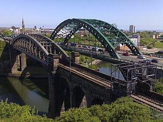
Wearmouth Bridge is a through arch bridge across the River Wear in Sunderland, England. It is the final bridge over the river before its mouth with the North Sea.

Scotswood Bridge is one of the main bridges crossing the River Tyne in North East England. It links the west end of Newcastle upon Tyne on the north bank of the river with the MetroCentre and Blaydon in Gateshead on the south bank. It is situated 5.2 km (3.2 mi) upstream of the better-known city centre bridges.

Scotswood Railway Bridge is a pipeline bridge and former railway bridge crossing the River Tyne in North East England. It previously carried the Newcastle and Carlisle Railway between Scotswood and Blaydon stations.
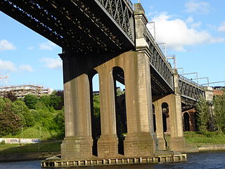
Monkwearmouth Railway Bridge is a railway bridge built in 1879, crossing the River Wear at Sunderland and Monkwearmouth. The bridge lies adjacent to and upstream of the Wearmouth Road Bridge.

Victoria Viaduct, originally known as the Victoria Bridge, is a stone arch rail viaduct spanning the River Wear about 1 mile (1.6 km) south-east of Washington in the City of Sunderland North East England. It was built as part of the Durham Junction Railway under the supervision of Thomas Elliot Harrison.
Witherwack is a suburb in the north of Sunderland, Tyne and Wear, England, situated between Red House to the west, Carley Hill to the east and Marley Pots to the south. The origin of the name Witherwack is unknown. The spelling of the name has changed since the Ordnance Survey maps of 1862 on which it was spelled Whitherwhack.
The York, Newcastle and Berwick Railway (YN&BR) was an English railway company formed in 1847 by the amalgamation of the York and Newcastle Railway as well as the Newcastle and Berwick Railway. Both companies were part of the group of business interests controlled by George Hudson, the so-called Railway King. In collaboration with the York and North Midland Railway and other lines he controlled, he planned that the YN&BR would form the major part of a continuous railway between London and Edinburgh. At this stage the London terminal was Euston Square and the route was through Normanton. This was the genesis of the East Coast Main Line, but much remained to be done before the present-day route was formed, and the London terminus was altered to King's Cross.

The Surtees Bridge is a road bridge carrying the A66(T) road east west across the River Tees near Thornaby-on-Tees in the borough of Stockton-on-Tees in the north east of England. The bridge is situated one kilometre upriver from Stockton town centre, just upriver of Surtees Rail Bridge – a rail bridge carrying the Tees Valley Line. Built at a cost of £14.3 million the bridge replaces an earlier Surtees Bridge (1981) that showed signs of distress resulting from excessive settlement.

The Victoria Swing Bridge is a swing bridge in Leith docks, Edinburgh, Scotland, which carries a dock road across the Water of Leith at a point where it is canalised as the Inner Harbour.

The Surtees Rail Bridge is a rail bridge on the Tees Valley Line over the River Tees in the Borough of Stockton-on-Tees. The bridge is south of Stockton-on-Tees town centre and just north of the adjacent Surtees Bridge which carries the A66 road. The bridge is built on the site of a series of Tees Bridges alternating between two adjacent crossing sites.

The Byker Viaduct is a 2,674 ft (815 m) curved S-shaped light railway bridge, which carries the Tyne and Wear Metro over the River Ouseburn in Newcastle upon Tyne. It carries the line from Manors Metro station in the city centre to the west, to Byker Metro station in the area of Byker to the east, over the lower Ouseburn valley, with the river emptying into the north side of the River Tyne, to the south. It was one of two major bridges built specifically for the Tyne and Wear Metro, the other being the Queen Elizabeth II Bridge crossing the River Tyne.


