Quinby, South Carolina

Last updated

Quinby, South Carolina
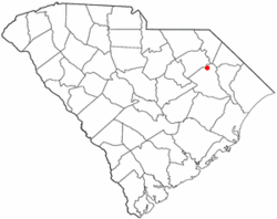
SCMap-doton-Quinby.PNG
Location of Quinby in South Carolina
Coordinates: 34°13′42″N79°43′57″W / 34.22833°N 79.73250°W / 34.22833; -79.73250
Country United States
State South Carolina
County Florence
Area
[1]
  Total1.31 sq mi (3.38 km2)
  Land1.31 sq mi (3.38 km2)
  Water0.00 sq mi (0.00 km2)
Elevation
118 ft (36 m)
Population
 (2020) [2]
  Total915
  Density700.08/sq mi (270.33/km2)
Time zone UTC-5 (EST)
  Summer (DST) UTC-4 (EDT)
ZIP code
29506
Area code(s) 843, 854
FIPS code 45-58795 [3]
GNIS feature ID1253496 [4]
Website www.townofquinby.com

Quinby is a town in Florence County, South Carolina, United States. The population was 932 at the 2010 census, [5] up from 842 in 2000. It is part of the Florence Metropolitan Statistical Area.

Contents

Geography

Quinby is located in northern Florence County at 34°13′42″N79°43′57″W / 34.22833°N 79.73250°W / 34.22833; -79.73250 (34.228445, -79.732460). [6] It is bordered on the south and west by the city of Florence, the county seat. The town limits extend north to Black Creek, a tributary of the Pee Dee River. Interstate 95 passes north and west of the town, with the closest access from Exit 169, 3 miles (5 km) to the north.

According to the United States Census Bureau, the town has a total area of 1.4 square miles (3.5 km2), all land. [5]

Demographics

Historical population
CensusPop.Note
1970 788
1980 95220.8%
1990 865−9.1%
2000 842−2.7%
2010 93210.7%
2020 915−1.8%
U.S. Decennial Census [7] [2]

As of the census [3] of 2000, there were 842 people, 331 households, and 254 families residing in the town. The population density was 755.6 inhabitants per square mile (291.7/km2). There were 351 housing units at an average density of 315.0 per square mile (121.6/km2). The racial makeup of the town was 42.87% White, 56.18% African American, 0.12% Native American, and 0.83% from two or more races. Hispanic or Latino of any race were 0.36% of the population.

There were 331 households, out of which 30.5% had children under the age of 18 living with them, 63.1% were married couples living together, 12.7% had a female householder with no husband present, and 23.0% were non-families. 22.1% of all households were made up of individuals, and 8.8% had someone living alone who was 65 years of age or older. The average household size was 2.54 and the average family size was 2.97.

In the town, the population was spread out, with 23.4% under the age of 18, 5.5% from 18 to 24, 24.3% from 25 to 44, 29.7% from 45 to 64, and 17.1% who were 65 years of age or older. The median age was 43 years. For every 100 females, there were 92.2 males. For every 100 females age 18 and over, there were 88.0 males.

The median income for a household in the town was $52,639, and the median income for a family was $55,556. Males had a median income of $33,125 versus $25,417 for females. The per capita income for the town was $22,804. About 8.1% of families and 7.8% of the population were below the poverty line, including 13.5% of those under age 18 and 1.8% of those age 65 or over.
Related Research Articles

<span class="mw-page-title-main">Florence County, South Carolina</span> County in South Carolina, United States

Florence County is a county located in the U.S. state of South Carolina. As of the 2020 census, its population was 137,059. Its county seat is Florence.

<span class="mw-page-title-main">Rogersville, Alabama</span> Town in Alabama, United States

Rogersville is a town in Lauderdale County, Alabama, United States. As of the 2018 census, the population of the town is 1,231, up from 1,199 in 2000.

<span class="mw-page-title-main">Parrish, Alabama</span> Town in Alabama, United States

Parrish is a town in Walker County, Alabama, United States. It was incorporated in October 1922. At the 2010 census the population was 982, down from 1,268 in 2000.

<span class="mw-page-title-main">Alhambra, Illinois</span> Village in Illinois, United States

Alhambra is a village in Madison County, Illinois, United States. The population was 622 at the 2020 census.

Woodstock is a town in Oxford County, Maine, United States. The population was 1,352 at the 2020 census. The village of Bryant Pond, on State Route 26 in the northern part of Woodstock, is the town's urban center and largest settlement.

<span class="mw-page-title-main">Napoleon, Michigan</span> Census-designated place & unincorporated community in Michigan, United States

Napoleon is an unincorporated community and census-designated place (CDP) in Jackson County in the U.S. state of Michigan. The population of the CDP was 1,258 at the 2010 census. It is located within Napoleon Township.

<span class="mw-page-title-main">Midway, Ohio</span> Village in Ohio, United States

Midway is a village in Range Township, Madison County, Ohio, United States. The population was 269 at the 2020 census.

<span class="mw-page-title-main">Everson, Pennsylvania</span> Borough in Pennsylvania, United States

Everson is a borough in Fayette County, Pennsylvania, United States. The population was 768 at the 2020 census. It was incorporated in 1903.

<span class="mw-page-title-main">Cherryhill Township, Indiana County, Pennsylvania</span> Township in Pennsylvania, United States

Cherryhill Township is a township in Indiana County, Pennsylvania, United States. It was named for Cherry Hill Manor, which was surveyed to the Penns. The population was 2,477 at the 2020 census. It includes the communities of Buck Run, Hustonville, Ideal, Kenwood, Manor, Manver, Mitchell's Mills, Penn Run, Pikes Peak, Rembrandt, Sample Run, and Weimer. The township surrounds but does not include the borough of Clymer.

<span class="mw-page-title-main">Bonneau, South Carolina</span> Town in South Carolina, United States

Bonneau is a town in Berkeley County, South Carolina, United States. The population was 487 at the 2010 census. It is part of the Charleston–North Charleston–Summerville Metropolitan Statistical Area.

<span class="mw-page-title-main">Olanta, South Carolina</span> Town in South Carolina, United States

Olanta is a town in Florence County, South Carolina, United States. The population was 563 at the 2010 census, down from 613 in 2000. It is part of the Florence Metropolitan Statistical Area.

<span class="mw-page-title-main">Pamplico, South Carolina</span> Town in South Carolina, United States

Pamplico is a town in southeastern Florence County, South Carolina, United States. The population was 1,226 at the 2010 census. It is part of the Florence Metropolitan Statistical Area.

<span class="mw-page-title-main">Scranton, South Carolina</span> Town in South Carolina, United States

Scranton is a town in Florence County, South Carolina, United States. The population was 932 at the 2010 census. It is part of the Florence Metropolitan Statistical Area.

<span class="mw-page-title-main">Timmonsville, South Carolina</span> Town in South Carolina, United States

Timmonsville is a town in Florence County, South Carolina, United States. The population was 2,320 at the 2010 census, an increase of five persons from 2000. It is part of the Florence Metropolitan Statistical Area.

<span class="mw-page-title-main">Florence, South Dakota</span> Town in South Dakota, United States

Florence is a town in northwestern Codington County, South Dakota, United States. It is part of the Watertown, South Dakota Micropolitan Statistical Area. The population was 337 at the 2020 census.

<span class="mw-page-title-main">Pearisburg, Virginia</span> Town in Virginia, United States

Pearisburg is a town in Giles County, Virginia, and the county seat. The population was 2,786 at the time of the 2010 census. Pearisburg is part of the Blacksburg–Christiansburg Metropolitan Statistical Area.

<span class="mw-page-title-main">Junior, West Virginia</span> Town in West Virginia, United States

Junior is a town in Barbour County, West Virginia, United States, situated along the Tygart Valley River. The population was 384 at the 2020 census.

<span class="mw-page-title-main">Bruceton Mills, West Virginia</span> Town in West Virginia, United States

Bruceton Mills is a town in northern Preston County, West Virginia, United States, along Big Sandy Creek. The population was 64 at the 2020 census, making it the second-least populous town in West Virginia, after Thurmond. It is part of the Morgantown metropolitan area.

<span class="mw-page-title-main">Montrose, West Virginia</span> Town in West Virginia, United States

Montrose is a town in Randolph County, West Virginia, United States. The population was 141 at the 2020 census.

<span class="mw-page-title-main">Hendricks, West Virginia</span> Town in West Virginia, United States

Hendricks is a town in Tucker County, West Virginia, United States. The population was 226 at the 2020 census. The Blackwater River and the Dry Fork join at Hendricks to form the Black Fork, a principal tributary of the Cheat River.

References

  1. "ArcGIS REST Services Directory". United States Census Bureau. Retrieved October 15, 2022.
  2. 1 2 "Census Population API". United States Census Bureau. Retrieved October 15, 2022.
  3. 1 2 "U.S. Census website". United States Census Bureau . Retrieved January 31, 2008.
  4. "US Board on Geographic Names". United States Geological Survey. October 25, 2007. Retrieved January 31, 2008.
  5. 1 2 "Geographic Identifiers: 2010 Demographic Profile Data (G001): Quinby town, South Carolina". U.S. Census Bureau, American Factfinder. Retrieved August 16, 2016.[ dead link ]
  6. "US Gazetteer files: 2010, 2000, and 1990". United States Census Bureau. February 12, 2011. Retrieved April 23, 2011.
  7. "Census of Population and Housing". Census.gov. Retrieved June 4, 2015.