Lake City, South Carolina

Last updated

Lake City, South Carolina
Historic Downtown Lake City.jpg
Historic Downtown Lake City
Lake City, SC City Seal.png
Motto(s): 
"Harvesting our past, cultivating our future" [1]
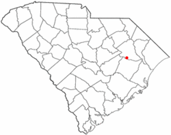
SCMap-doton-LakeCity.PNG
Location of Lake City in South Carolina
Coordinates: 33°52′4″N79°45′22″W / 33.86778°N 79.75611°W / 33.86778; -79.75611
Country United States
State South Carolina
County Florence
Settled1736
Government
   Mayor Yamekia Robinson. [2]
  City AdministratorWilliam A. Hall [3]
Area
[4]
  Total5.46 sq mi (14.13 km2)
  Land5.45 sq mi (14.11 km2)
  Water0.01 sq mi (0.02 km2)
Elevation
75 ft (23 m)
Population
 (2020) [5]
  Total5,903
  Density1,083.32/sq mi (418.31/km2)
Time zone UTC-5 (EST)
  Summer (DST) UTC-4 (EDT)
ZIP code
29560
Area code(s) 843, 854
FIPS code 45-39310 [6]
GNIS feature ID1246275 [7]
Website www.lakecitysc.gov

Lake City is a city in Florence County, South Carolina, United States. The population was 6,675 at the 2010 census. [8] Located in central South Carolina, it is south of Florence and included as part of the Florence Metropolitan Statistical Area.

Contents

History

The Lake City area was originally part of Williamsburg Township, which was first settled by a group of Scots-Irish in 1736. It was first called "Graham's Crossroads" and then "Graham", after Aaron Graham, a land owner around the crossroads that now form Church and Main streets in Lake City.

In 1856, the Northeastern Railroad built its main line through the area. This brought new growth to the community. On March 4, 1874, after requests from residents, a city charter was granted to the new town of Graham. On December 24, 1883, the town changed its name to "Lake City", after the swimming lakes just north of town. This was at the request of the locally-serving Lynches Lake Post Office, since there was another post office in South Carolina known as that.

This small town had a population of 300 in 1893, and by 1898 the area had become the leading strawberry cropland in South Carolina.

Lake City was the site of a notorious lynching on February 22, 1898, that resulted in the mob murders of the city's black postmaster and his infant daughter. [9] [10]

Lake City was at one time called the "Bean Capital of the World", and the Bean Market downtown has now been converted into an event rental and civic center facility. The building was built in 1936 by the Public Works Administration (PWA), and was a central hub for farmers across the South to get their beans to market. The building is listed in the National Register of Historic Places as a contributing property in the Lake City Downtown Historic District. [11] Also listed on the National Register of Historical Places is the W.T. Askins House. [12]

Government

Lake City's city government includes a mayor (elected for a four-year term), an appointed city administrator, and a six-person city council (elected to single-member districts for a four-year staggered term of office). The city's mayor is Yamekia Robinson.

Geography

Lake City is located in southern Florence County at 33°52′4″N79°45′22″W / 33.86778°N 79.75611°W / 33.86778; -79.75611 (33.867697, -79.756153). [13] U.S. Route 52 is the main highway through the city, leading north 24 miles (39 km) to Florence, the county seat, and south 17 miles (27 km) to Kingstree. U.S. Route 378 crosses US 52 1.5 miles (2.4 km) north of the city center, leading east 45 miles (72 km) to Conway and west 35 miles (56 km) to Sumter.

According to the United States Census Bureau, Lake City has a total area of 5.2 square miles (13.5 km2), of which 0.01 square miles (0.02 km2), or 0.15%, is water. [8] Lake Swamp drains the northern part of the city, flowing east to the Lynches River and then the Pee Dee River.

Climate

Climate data for Lake City, South Carolina (1991–2020 normals, extremes 1936–present)
MonthJanFebMarAprMayJunJulAugSepOctNovDecYear
Record high °F (°C)81
(27)
85
(29)
92
(33)
94
(34)
102
(39)
106
(41)
105
(41)
106
(41)
103
(39)
101
(38)
89
(32)
83
(28)
106
(41)
Average high °F (°C)57.6
(14.2)
61.3
(16.3)
68.0
(20.0)
77.1
(25.1)
83.4
(28.6)
89.4
(31.9)
92.4
(33.6)
90.5
(32.5)
85.9
(29.9)
77.3
(25.2)
68.1
(20.1)
60.6
(15.9)
76.0
(24.4)
Daily mean °F (°C)46.0
(7.8)
49.2
(9.6)
55.3
(12.9)
63.6
(17.6)
71.4
(21.9)
78.4
(25.8)
81.8
(27.7)
80.4
(26.9)
75.3
(24.1)
65.1
(18.4)
55.1
(12.8)
48.8
(9.3)
64.2
(17.9)
Average low °F (°C)34.3
(1.3)
37.0
(2.8)
42.6
(5.9)
50.1
(10.1)
59.4
(15.2)
67.3
(19.6)
71.3
(21.8)
70.3
(21.3)
64.6
(18.1)
52.9
(11.6)
42.2
(5.7)
36.9
(2.7)
52.4
(11.3)
Record low °F (°C)2
(−17)
5
(−15)
10
(−12)
26
(−3)
35
(2)
46
(8)
53
(12)
53
(12)
42
(6)
26
(−3)
17
(−8)
6
(−14)
2
(−17)
Average precipitation inches (mm)3.65
(93)
3.48
(88)
3.60
(91)
3.19
(81)
4.20
(107)
4.84
(123)
5.77
(147)
5.81
(148)
4.74
(120)
3.52
(89)
3.13
(80)
3.85
(98)
49.78
(1,264)
Source: NOAA [14] [15]

Demographics

Historical population
CensusPop.Note
1900 374
1910 1,074187.2%
1920 1,60649.5%
1930 1,94220.9%
1940 2,52229.9%
1950 5,112102.7%
1960 6,05918.5%
1970 6,2473.1%
1980 6,7317.7%
1990 7,1536.3%
2000 6,478−9.4%
2010 6,6753.0%
2020 5,903−11.6%
U.S. Decennial Census [16] [5]

2020 census

Lake City Racial Composition [17]
RaceNum.Perc.
White 93315.81%
Black or African American 4,64778.72%
Native American 210.36%
Asian 270.46%
Other/Mixed 1432.42%
Hispanic or Latino 1322.24%

As of the 2020 United States Census, there were 5,903 people, 2,415 households, and 1,568 families residing in the city.

2000 census

As of the census [6] of 2000, there were 6,478 people, 2,409 households, and 1,705 families residing in the city. The population density was 1,365.0 inhabitants per square mile (527.0/km2). There were 2,704 housing units at an average density of 569.8 per square mile (220.0/km2). The racial makeup of the city was 71.43% African American, 27.18% White, 0.08% Native American, 0.34% Asian, 0.28% from other races, and 0.69% from two or more races. Hispanic or Latino of any race were 1.10% of the population.

There were 2,409 households, out of which 33.3% had children under the age of 18 living with them, 36.6% were married couples living together, 30.5% had a female householder with no husband present, and 29.2% were non-families. 26.7% of all households were made up of individuals, and 11.2% had someone living alone who was 65 years of age or older. The average household size was 2.67 and the average family size was 3.25.

In the city, the population was spread out, with 29.7% under the age of 18, 9.5% from 18 to 24, 25.8% from 25 to 44, 21.5% from 45 to 64, and 13.5% who were 65 years of age or older. The median age was 34 years. For every 100 females, there were 79.7 males. For every 100 females age 18 and over, there were 71.4 males.

The median income for a household in the city was $22,534, and the median income for a family was $32,111. Males had a median income of $26,316 versus $19,679 for females. The per capita income for the city was $14,452. About 26.9% of families and 31.6% of the population were below the poverty line, including 45.0% of those under age 18 and 25.3% of those age 65 or over.

Education

Lake City has a public library, a branch of the Florence County Library System. [18]

Notable people

Astronaut Ronald McNair. Lake City has several sites named in McNair's honor, including a public library and memorial park. Ronald mcnair.jpg
Astronaut Ronald McNair. Lake City has several sites named in McNair’s honor, including a public library and memorial park.

Related Research Articles

<span class="mw-page-title-main">Williamsburg County, South Carolina</span> County in South Carolina, United States

Williamsburg County is a county located in the U.S. state of South Carolina. As of the 2020 census its population was 31,026. The county seat and largest city is Kingstree. After a previous incarnation of Williamsburg County, the current county was created in 1804.

<span class="mw-page-title-main">Marlboro County, South Carolina</span> County in South Carolina, United States

Marlboro County is a county located in the Pee Dee region on the northern border of the U.S. state of South Carolina. As of the 2020 census, its population was 26,667. Its county seat is Bennettsville. The Great Pee Dee River runs through it. Marlboro County comprises the Bennettsville, SC Micropolitan Statistical Area.

<span class="mw-page-title-main">Marion County, South Carolina</span> County in South Carolina, United States

Marion County is a county located in the coastal plain of the U.S. state of South Carolina. As of the 2020 census, its population was 29,183. Its county seat is Marion. It is a majority-minority county.

<span class="mw-page-title-main">Lexington County, South Carolina</span> County in South Carolina, United States

Lexington County is a county located in the U.S. state of South Carolina. As of the 2020 census, the population was 293,991. Its seat of government and largest town is Lexington. The county was chartered in 1785 and was named in commemoration of Lexington, Massachusetts, the site of the Battle of Lexington in the American Revolutionary War. Lexington County is the sixth-largest county in South Carolina by population and is part of the Columbia, SC Metropolitan Statistical Area. It is located in the Midlands region of South Carolina.

<span class="mw-page-title-main">Lancaster County, South Carolina</span> County in South Carolina, United States

Lancaster County is a county located in the U.S. state of South Carolina. As of the 2020 census, its population was 96,016, Its county seat is Lancaster, which has an urban population of 23,979. The county was created in 1785.

<span class="mw-page-title-main">Kershaw County, South Carolina</span> County in South Carolina, United States

Kershaw County is a county located in the U.S. state of South Carolina. As of the 2020 census, its population was 65,403. The county seat and largest city is Camden. The county was created in 1791 from parts of Claremont, Lancaster, Fairfield, and Richland counties. It is named for Col. Joseph Kershaw (1727–1791), an early settler and American Revolutionary War patriot.

<span class="mw-page-title-main">Hampton County, South Carolina</span> County in South Carolina, United States

Hampton County is a rural county located in the U.S. state of South Carolina. As of the 2020 census, the population was 18,561. Its county seat is Hampton. It was named for Confederate Civil War general Wade Hampton, who in the late 1870s, with the ending of Reconstruction, was elected as governor of South Carolina.

<span class="mw-page-title-main">Florence County, South Carolina</span> County in South Carolina, United States

Florence County is a county located in the U.S. state of South Carolina. As of the 2020 census, its population was 137,059. Its county seat is Florence.

<span class="mw-page-title-main">Dillon County, South Carolina</span> County in South Carolina, United States

Dillon County is a county located in the U.S. state of South Carolina. As of the 2020 census, the county's population was 28,292. The county seat is Dillon.

<span class="mw-page-title-main">Darlington County, South Carolina</span> County in South Carolina, United States

Darlington County is a county in the U.S. state of South Carolina. As of the 2020 census, its population was 62,905. Its county seat is Darlington. Hartsville is the largest city in the county. Darlington County is home to the Darlington Raceway, which hosts the annual NASCAR Southern 500. Darlington County is also home to Coker College in Hartsville. Darlington County was named by an act in March 1785.

<span class="mw-page-title-main">Calhoun County, South Carolina</span> County in South Carolina, United States

Calhoun County is a county in the U.S. state of South Carolina. As of the 2020 census, its population was 14,119, making it the third-least populous county in the state. Its county seat is St. Matthews. In terms of land area, it is also the smallest county in the state.

<span class="mw-page-title-main">Berkeley County, South Carolina</span> County in South Carolina, United States

Berkeley County is a county in the U.S. state of South Carolina. As of the 2020 census, its population was 229,861. Its county seat is Moncks Corner, and the largest city is Goose Creek. After two previous incarnations of Berkeley County, the current county was created in 1882. Berkeley County is included in the Charleston-North Charleston, SC Metropolitan Statistical Area.

<span class="mw-page-title-main">Abbeville County, South Carolina</span> County in South Carolina, United States

Abbeville County is a county located in the U.S. state of South Carolina. As of the 2020 census, its population was 24,295. Its county seat is Abbeville. It is the first county in the United States alphabetically. Abbeville County included in the Greenville-Spartanburg-Anderson, SC Combined Statistical Area.

<span class="mw-page-title-main">Coward, South Carolina</span> Town in South Carolina, United States

Coward is a town in Florence County, South Carolina, United States. The population was 752 at the 2010 census, up from 650 in 2000. It is part of the Florence Metropolitan Statistical Area.

<span class="mw-page-title-main">Johnsonville, South Carolina</span> City in South Carolina, United States

Johnsonville is a city in Florence County, South Carolina, United States. The population was 1,480 at the 2010 census. It is part of the Florence Metropolitan Statistical Area.

<span class="mw-page-title-main">Olanta, South Carolina</span> Town in South Carolina, United States

Olanta is a town in Florence County, South Carolina, United States. The population was 563 at the 2010 census, down from 613 in 2000. It is part of the Florence Metropolitan Statistical Area.

<span class="mw-page-title-main">Pamplico, South Carolina</span> Town in South Carolina, United States

Pamplico is a town in southeastern Florence County, South Carolina, United States. The population was 1,226 at the 2010 census. It is part of the Florence Metropolitan Statistical Area.

<span class="mw-page-title-main">Scranton, South Carolina</span> Town in South Carolina, United States

Scranton is a town in Florence County, South Carolina, United States. The population was 932 at the 2010 census. It is part of the Florence Metropolitan Statistical Area.

<span class="mw-page-title-main">Timmonsville, South Carolina</span> Town in South Carolina, United States

Timmonsville is a town in Florence County, South Carolina, United States. The population was 2,320 at the 2010 census, an increase of five persons from 2000. It is part of the Florence Metropolitan Statistical Area.

<span class="mw-page-title-main">Marion, South Carolina</span> City in South Carolina, United States

Marion is a city in and the county seat of Marion County, South Carolina, United States. It is named for Francis Marion, a brigadier general from South Carolina in the American Revolutionary War. The population was 6,939 at the 2010 census.

References

  1. studio, {e} house. "Lake City, SC" . Retrieved February 23, 2017.
  2. "Greetings From the Mayor - Lake City, SC". lakecitysc.gov. Retrieved January 6, 2020.
  3. "City Administrator - Lake City, SC". lakecitysc.gov. Retrieved January 6, 2020.
  4. "ArcGIS REST Services Directory". United States Census Bureau. Retrieved October 15, 2022.
  5. 1 2 "Census Population API". United States Census Bureau. Retrieved October 15, 2022.
  6. 1 2 "U.S. Census website". United States Census Bureau . Retrieved January 31, 2008.
  7. "US Board on Geographic Names". United States Geological Survey. October 25, 2007. Retrieved January 31, 2008.
  8. 1 2 "Geographic Identifiers: 2010 Demographic Profile Data (G001): Lake City city, South Carolina". U.S. Census Bureau, American Factfinder. Retrieved August 15, 2016.[ dead link ]
  9. "The Lake City Lynching: Thirteen Men Indicted in a Federal Court for the Alleged Murder of a Negro Postmaster", New York Times , April 8, 1899.
  10. David C. Carter, "The Lynching of Postmaster Frazier Baker and His Infant Daughter Julia in Lake City, South Carolina, in 1898 and its Aftermath" Archived 2009-02-12 at the Wayback Machine in African-Americans and South Carolina: History, Politics, and Culture , at University of South Carolina Aiken website (retrieved May 20, 2009).
  11. studio, {e} house. "Lake City, SC" . Retrieved February 23, 2017.
  12. "National Register Information System". National Register of Historic Places . National Park Service. July 9, 2010.
  13. "US Gazetteer files: 2010, 2000, and 1990". United States Census Bureau. February 12, 2011. Retrieved April 23, 2011.
  14. "NOWData - NOAA Online Weather Data". National Oceanic and Atmospheric Administration. Retrieved October 11, 2023.
  15. "Summary of Monthly Normals 1991-2020". National Oceanic and Atmospheric Administration. Retrieved October 11, 2023.
  16. "Census of Population and Housing". Census.gov. Retrieved June 4, 2015.
  17. "Explore Census Data". data.census.gov. Retrieved December 7, 2021.
  18. "South Carolina libraries and archives". SCIWAY. Retrieved June 8, 2019.
  19. "Dr. Brad J. Cox Ph.D. Obituary - Manassas, VA | SCNow". www.legacy.com. Retrieved February 11, 2021.
  20. Derrick Faison at NFL.com (accessed 2012-08-23).
  21. Robin Hinch, "Former football player found niche in teaching", Orange County Register , July 1, 2004.