
Transport in Pakistan is extensive and varied, and serves a population of over 212.2 million people. In recent years, new national highways have been built, with the addition of motorways which have improved trade and logistics within the country. Pakistan's rail network owned by Pakistan Railways is also undergoing expansion in recent years. Airports and seaports have been built with the addition of foreign and domestic funding.

Rawalpindi (pronounced [raːwəlˈpɪndi] or ;, is the capital city of Rawalpindi Division located in the Punjab province of Pakistan. Rawalpindi is the fourth-largest city proper in Pakistan after Karachi, Lahore and Faisalabad respectively while the larger Islamabad-Rawalpindi metropolitan area is the country's third largest metropolitan area. Rawalpindi is adjacent to Pakistan's capital of Islamabad, and the two are jointly known as the "twin cities" on account of strong social and economic links between the cities.
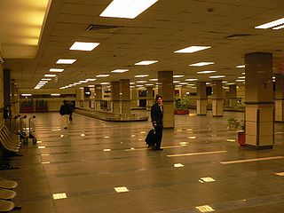
Benazir Bhutto International Airport is a defunct airport which formerly served the Islamabad-Rawalpindi metropolitan area. It was the second-largest airport by air traffic in Pakistan, until 3 May 2018 when it was replaced by the new Islamabad International Airport. Previously also known as Islamabad International Airport, it was renamed after the late Pakistani prime minister Benazir Bhutto in June 2008. The airport handled 4,767,860 passengers in 2015–16, compared to 3,610,566 in 2010–11.

Rawalpindi District is a district located in the northernmost part of the Punjab province of Pakistan. Parts of the district form part of the Islamabad Rawalpindi metropolitan area. Rawalpindi city is the district capital.

Pakistan Railways is the national, state-owned railway company of Pakistan. Founded in 1861 and headquartered in Lahore, it owns 7,791 kilometres of track across Pakistan, stretching from Torkham to Karachi, offering both freight and passenger services.
Sargodha is a city and capital of Sargodha Division, located in Punjab province, Pakistan. It is Pakistan's 12th largest city by population and one of the fastest-growing cities of the country. Sargodha is also known as the City of Eagles.
Gujar Khan is a city in Rawalpindi District, Punjab, Pakistan. It is also the headquarters of Gujar Khan Tehsil, the largest tehsil of Punjab by land area.
Chichawatni is a city in the Sahiwal District of the Punjab province of Pakistan. It is the administrative center of Chichawatni Tehsil. Situated near the old main road called Grand Trunk Road, it lies approximately 45 kilometres (28 mi) from the district capital, Sahiwal. In 2011, Chichawatni's population was estimated at approximately 160,000.
Pakistan Air Force Base Nur Khan is an active Pakistan Air Force airbase located in Chaklala, Rawalpindi, Punjab province, Pakistan. The former Benazir Bhutto International Airport forms part of this airbase. Fazaia Intermediate College, Nur Khan is also located in the base.
Lalkurti, is a locality in the heart of Rawalpindi cantonment in Pakistan. Places with the same name are also found in many other garrison cities of Pakistan and India, such as Peshawar, Lahore, Kanpur, Ambala, Meerut and Delhi.
Chaklala is a major suburban town of Rawalpindi in the Punjab province of Pakistan.
Saddar, Rawalpindi, Pakistan, is the main commercial hub of Rawalpindi Cantonment. It is located between the Mall road and the main railway lines connecting Rawalpindi with down-country. It has some major business and commercial centres, main branches of major Pakistani banks, and residential areas of British colonial era. Saddar is a home to a dense cluster of residential and commercial buildings. Shops as well as shopping malls offer a diverse range of locally manufactured products and imported items. Chota Bazaar is a famous shopping area in northern Saddar.
Rawalpindi Cantonment is a large cantonment located in Rawalpindi, Punjab province, Pakistan. The headquarters of the Pakistan Army which are known as the General Headquarters (GHQ) are located in the Rawalpindi cantonment.
IIUI Schools, is a school system launched by International Islamic University, Islamabad in 2010 on occasion of its Silver Jubilee (1985–2010). The IIUI Schools, also known as, International Islamic University Schools, are the first school system established by a university in Pakistan, aimed to assist in creating high achievers with an advanced level of independent thinking, impeccable character and remarkable confidence in line with the teachings and norms taught by Islam.

For Islamabad, all major cities and towns are accessible through regular trains and bus services running mostly from the neighbouring city of Rawalpindi. Lahore and Peshawar are linked to Islamabad through a network of motorways which has resulted in a significant reduction in travelling times between these cities. M-2 Motorway is 367 km long and connects Islamabad with Lahore. M-1 Motorway connects Islamabad with Peshawar and is 155 km long. Islamabad is linked to its 'Twin' city Rawalpindi through the Faizabad Interchange, the first cloverleaf interchange in Pakistan with a daily traffic volume of about 48,000 vehicles (2011).
NA-59 (Rawalpindi-III) is a constituency for the National Assembly of Pakistan.
NA-61 (Rawalpindi-V) is a constituency for the National Assembly of Pakistan.
Springfield Public School & College is a Pakistani educational institution with several campuses in Rawalpindi. It was founded in 1984 by Yawar Azhar.

Multan Cantt or Multan Cantonment is a cantonment in the Multan District, adjacent to Multan city, in Punjab province, eastern Pakistan. Multan Cantt is located in the city's southwest.

The Islamabad–Rawalpindi metropolitan area is one of Pakistan's largest metropolitan areas. It consists principally of the twin cities of Islamabad and Rawalpindi, along with several gated suburbs including DHA Islamabad and Bahria Town.

