
The Missouri River is the longest river in the United States. Rising in the Rocky Mountains of the Eastern Centennial Mountains of Southwestern Montana, the Missouri flows east and south for 2,341 miles (3,767 km) before entering the Mississippi River north of St. Louis, Missouri. The river drains a sparsely populated, semi-arid watershed of more than 500,000 square miles (1,300,000 km2), which includes parts of ten U.S. states and two Canadian provinces. Although a tributary of the Mississippi, the Missouri River is slightly longer and carries a comparable volume of water. When combined with the lower Mississippi River, it forms the world's fourth longest river system.

The Deschutes River in central Oregon is a major tributary of the Columbia River. The river provides much of the drainage on the eastern side of the Cascade Range in Oregon, gathering many of the tributaries that descend from the drier, eastern flank of the mountains. The Deschutes provided an important route to and from the Columbia for Native Americans for thousands of years, and then in the 19th century for pioneers on the Oregon Trail. The river flows mostly through rugged and arid country, and its valley provides a cultural heart for central Oregon. Today the river supplies water for irrigation and is popular in the summer for whitewater rafting and fishing.

Toketee Falls is a waterfall in Douglas County, Oregon, United States, on the North Umpqua River at its confluence with the Clearwater River. It is located approximately 58 miles (93 km) east of Roseburg near Oregon Route 138.

The Great Falls of the Missouri River are a series of waterfalls on the upper Missouri River in north-central Montana in the United States. From upstream to downstream, the five falls along a 10-mile (16 km) segment of the river are:

Gavins Point Dam is a 1.9 mi (3 km) long embankment rolled-earth and chalk-fill dam which spans the Missouri River and impounds Lewis and Clark Lake. The dam joins Cedar County, Nebraska with Yankton County, South Dakota a distance of 811.1 river miles (1,305 km) upstream of St. Louis, Missouri, where the river joins the Mississippi River. The dam and hydroelectric power plant were constructed as the Gavins Point Project from 1952 to 1957 by the United States Army Corps of Engineers as part of the Pick-Sloan Plan. The dam is located approximately 4 miles (6.4 km) west or upstream of Yankton, South Dakota.

Lewis and Clark Lake is a 31,400 acre (130 km²) reservoir located on the border of the U.S. states of Nebraska and South Dakota on the Missouri River. The lake is approximately 25 miles (40 km) in length with over 90 miles (140 km) of shoreline and a maximum water depth of 45 feet (14 m). The lake is impounded by Gavins Point Dam and is managed by the U.S. Army Corps of Engineers, Omaha District.

The Rana Pratap Sagar Dam is a gravity masonry dam of 53.8 metres (177 ft) height built on the Chambal River at Rawatbhata in Rajasthan in India. It is part of integrated scheme of a cascade development of the river involving four projects starting with the Gandhi Sagar Dam in the upstream reach in Madhya Pradesh and the Jawahar Sagar Dam on the downstream with a terminal structure of the Kota Barrage in Rajasthan for irrigation.

Yellowtail Dam is a dam across the Bighorn River in south central Montana in the United States. The mid-1960s era concrete arch dam serves to regulate the flow of the Bighorn for irrigation purposes and to generate hydroelectric power. The dam and its reservoir, Bighorn Lake, are owned by the U.S. Bureau of Reclamation.
Calderwood Dam is a hydroelectric dam located along the Little Tennessee River in Blount and Monroe counties, in the U. S. state of Tennessee. Completed in 1930, the dam is owned and maintained by Tapoco, a subsidiary of the Aluminum Company of America (Alcoa), although the Tennessee Valley Authority controls the dam's reservoir levels from Fontana Dam further upstream. Calderwood Dam is named for Alcoa engineer Isaac Glidden Calderwood (1871–1941), who supervised much of the company's early Little Tennessee River operations.
Colter Falls, also called Coulter Falls, is a waterfall on the Missouri River in north-central Montana, and part of the Great Falls of the Missouri. Downstream of Colter Falls lies Rainbow Falls, and upstream is Black Eagle Falls. The falls is now flooded in the impoundment behind Rainbow Dam. As Rainbow Dam's reservoir is a run-of-the-river reservoir, it rarely is emptied, so the falls are rarely seen even in extreme drought.

Rainbow Dam is a hydroelectric dam on the Missouri River, 29 feet (8.8 m) high and 1,055 feet (322 m) long, located six miles northeast of Great Falls in the U.S. state of Montana.

Ryan Dam is a hydroelectric dam on the Missouri River, 10 miles (16 km) downstream from the city of Great Falls in the U.S. state of Montana. The dam is 1,336 feet (407 m) long and 61 feet (19 m) high; its reservoir is 7 miles (11 km) long and has a storage capacity of 5,000 acre-feet (6,200,000 m3). It is a run-of-river dam. The dam is built on the largest of the five Great Falls of the Missouri, the "Big Falls", also sometimes called "Great Falls". Since 1915, the six-unit powerhouse on the left side of the dam has occupied a significant portion of the 87-foot (27 m) high waterfall.

Holter Dam is a hydroelectric straight gravity dam on the Missouri River about 45 miles (72 km) northeast of Helena, Montana, in the United States. The dam, which was built between 1908 and 1918, is 1,364 feet (416 m) long and 124 feet (38 m) high. The reservoir formed by the dam, Holter Lake is 25 miles (40 km) long and has a storage capacity of 243,000 acre-feet (300,000,000 m3) of water when full. The dam is a "run-of-the-river" dam because it can generate electricity without needing to store additional water supplies behind the dam.

Hauser Dam is a hydroelectric straight gravity dam on the Missouri River about 14 miles (23 km) northeast of Helena, Montana, in the United States. The original dam, built between 1905 and 1907, failed in 1908 and caused severe flooding and damage downstream. A second dam was built on the site in 1908 and opened in 1911 and comprises the present structure. The current Hauser Dam is 700 feet (210 m) long and 80 feet (24 m) high. The reservoir formed by the dam, Hauser Lake, is 25 miles (40 km) long, has a surface area of 3,800 acres (1,500 ha), and has a storage capacity of 98,000 acre-feet (121,000,000 m3) of water when full.

Aldeadávila Dam is a concrete arch-gravity dam on the Duero River in Spain, near the border with Portugal. The nearest town is Aldeadávila de la Ribera in the Province of Salamanca, about 11.3 kilometres (7.0 mi) to the east. The nearest Portuguese town is Fornos in Bragança District, about 8 kilometres (5.0 mi) to the southwest. The Portuguese side of the river around the dam site lies within the Arribes del Duero Natural Park.
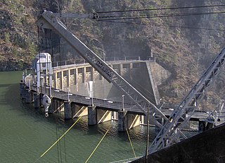
Black Eagle Dam is a hydroelectric gravity weir dam located on the Missouri River in the city of Great Falls, Montana. The first dam on the site, built and opened in 1890, was a timber-and-rock crib dam. This structure was the first hydroelectric dam built in Montana and the first built on the Missouri River. The dam helped give the city of Great Falls the nickname "The Electric City." A second dam, built of concrete in 1926 and opened in 1927, replaced the first dam, which was not removed and lies submerged in the reservoir. Almost unchanged since 1926, the dam is 782 feet (238 m) long and 34.5 feet (10.5 m) high, and its powerhouse contains three turbines capable of generating seven megawatts (MW) of power each. The maximum power output of the dam is 18 MW. Montana Power Company built the second dam, PPL Corporation purchased it in 1997 and sold it to NorthWestern Corporation in 2014. The reservoir behind the dam has no official name, but was called the Long Pool for many years. The reservoir is about 2 miles (3.2 km) long, and has a storage capacity of 1,710 acre-feet (2,110,000 m3) to 1,820 acre-feet (2,240,000 m3) of water.

Ruskin Dam is a concrete gravity dam on the Stave River in Ruskin, British Columbia, Canada. The dam was completed in 1930 for the primary purpose of hydroelectric power generation. The dam created Hayward Lake, which supplies water to a 105 MW powerhouse and flooded the Stave's former lower canyon, which ended in a small waterfall approximately where the dam is today.
Big Falls is a major waterfall located on the Missouri River in western Montana in the United States. It is the lowermost and largest of the Great Falls of the Missouri, at 87 feet (27 m) high and up to 900 feet (270 m) wide at peak flow. Although the falls used to flow powerfully year-round, most of the water is now diverted to the 60 megawatt hydroelectric plant of upstream Ryan Dam, reducing it to a trickle in the summer months. The dam raised the total height of the water to 177 feet.

Gibson Dam is a concrete arch dam on the Sun River, a tributary of the Missouri River, about 60 miles (97 km) west of Great Falls, Montana in the United States. Located on the eastern edge of the Rocky Mountains, the dam was built by the U.S. Bureau of Reclamation (USBR) between 1926 and 1929 as part of the Sun River Project to develop about 93,000 acres (38,000 ha) of irrigated land in the Sun River Valley.

Moore Dam is a major hydroelectric dam on the Upper Connecticut River between Grafton County, New Hampshire and Caledonia County, Vermont in the northeastern United States. The dam is located near Littleton, New Hampshire, and forms the 3,490-acre (1,410 ha) Moore Reservoir. The Moore Station is the largest conventional hydroelectric plant in New England, in terms of installed capacity and average power generation. The dam and reservoir also provide flood control, recreational boating and fishing.

