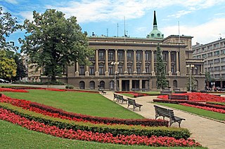
Raipur district is a district in the Chhattisgarh state of India. Raipur is the administrative headquarters of the district. The district is rich in mineral resources. There are many wild life sanctuaries and sight seeing places worth visiting. The district has the population of 30 lakhs.

Khairagarh is a town in Rajnandgaon District in the Indian state of Chhattisgarh. Administered by a nagar palika (Pālikā) parishad, Khairagarh city have cbse pattern schools as well as has kvs but not have a wide network of roads and railway tracks.
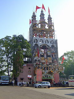
Kawardha is a city and a municipality in Kabirdham district in the Indian state of Chhattisgarh. It is the administrative headquarters of Kabirdham district. Kawardha is also known for the "Temple of Bhoramdeo."
Kumhari is a city located in the Indian state of Chhattisgarh. It is a part of the Durg district of the state. It is situated at the twenty-one degrees and sixteen minutes north latitude. Its longitudinal position is eighty-one degrees and thirty-one minutes east. It is situated at an average elevation of 284 meters above the sea level.

Dhamtari is abbreviated from "Dhamma" + "Tarai" district and is situated in the fertile plains of the Chhattisgarh region. This district is situated at 20°42' N latitude and 81°33' E longitude. Dhamtari district was officially formed on 6 July 1998 dividing the Raipur district currently the capital of Chhattisgarh along with Mahasamund. As a result, the boundaries of the Raipur district is converted into the districts e.g. Raipur, Mahasamund and Dhamtari. Dhamtari, Kurud and Nagari are included in Dhamtari district as tehsils and Dhamtari, Kurud, Nagari and Magarlod are included as blocks. The total area of the district is 2029 km2 and 305 meters above mean sea level. The district is surrounded by District Raipur in the north and District Kanker as well as Bastar in the south, part of Orissa state in east and District Durg and Kanker in west. Mahanadi is the principal river of this district and Mahanadi is so far named as Kankannadi, Chitrotpala, Neelotpala, Mandvahini, Jairath, etc. Its tributaries being Pairy, Sondur, Jonk, Kharun and Shivnath. The fertility of lands of Dhamtari district can be attributed to the presence of these rivers. The chief crop of this region is paddy. Mahanadi; one of the major rivers in central India originates in the hills of Sihawa and flows two the east into the Bay of Bengal. Dhamtari district falls between two Lok Sabha constituencies and three Assembly constituencies. National Highway No. 30 Raipur – Vizianagaram passes through Dhamtari. Raipur is 78 km from Dhamtari. A unique feature of Dhamtari is the total number of rice mills, more than 136. In the east, Satpura range is located. It is popularly known as Sihawa pahad. Kanker district lies in the west. In North lies Raipur, the heart and capital city of Chhattisgarh. Southwards lies the boundary of Odisha state. Ravishankar Sagar dam that irrigates almost 57000 Hectare of land and also acts as a main supply unit of safe drinking water resource for state capital Raipur as well as supply to Bhilai Steel Plant lies at almost 11 km from the District capital. Work of 10 MW hydro-electric power plant is progressing and is likely to be completed very soon. Asia's first ever Siphon dam was built in the year 1914 at Madamsilli. Besides Madamsilli, Sondur dam, Dudhawa dam are the major projects.

Indira Gandhi Krishi Vishwavidyalaya (IGKV), also Indira Gandhi Agricultural University (IGAU) is an agricultural university located in Raipur, Chhattisgarh, India.

Kushabhau Thakre Patrakarita Avam Jansanchar Vishwavidyalaya, also Kushabhau Thakre University of Journalism and Mass Communication (KTUJM), is a journalism and mass communication university located in Raipur, Chhattisgarh. The University established by Government of Chhattisgarh vide Act no 24 of 2004. Former Prime Minister a visionary statesman and a dedicated journalist Shri Atal Bihari Vajpayee inaugurated the University on April 16, 2005 at Raipur amidst the greasing of eminent journalist, educationalist, literature, social workers and senior politicians. The university is named after Late Sri Kushabhau Thakre who was one of the great political leaders of the country. Foundation day is celebrated on 16 April every year.

Pt. Ravishankar Shukla University is an institution of higher education located in Raipur, Chhattisgarh, India. It is one of the largest and oldest institution of higher education in Chhattisgarh. It is a State university founded in 1964 by Government of Madhya Pradesh. It is a teaching-cum-affiliating university which affiliates 129 colleges and has 29 University Teaching Departments (UTDs)
Naya Raipur, officially known as Atal Nagar, is an upcoming city in Chhattisgarh. "Mantralay", the states's administrative body is situated here. The city is located between National Highways NH-53 and NH-30, about 17 km south-east of the capital city Raipur; Swami Vivekananda Airport separates Raipur and Naya Raipur.
One of the newly formed states in India, Chhattisgarh covers an area of 135,194 km2. It was recognized as a state on 1 November 2000. The education scenario in Chhattisgarh is not very remarkable as it lacks proper educational infrastructure. However, the state government has launched several programs for enhancing the academic scenario of the state. The overall growth in the literacy rate has been possible due to the persistent efforts of the state government. According to the 2001 census report, Chhattisgarh had a literacy rate of 65.18% which included male and female literacy rate of 77.86% and 52.40% respectively. Special importance is given to the education of women and students belonging to the underprivileged section of the society. The capital city Raipur is the main center of higher education in Chhattisgarh. It houses some of the most important departments of education in the state.
MATS University,, is a Private University located in Raipur, Chhattisgarh, India. It was established by Chhattisgarh Private University Act under Section 2(f) of UGC Act 1956.
The City Center Raipur is a large new shopping mall in the city of Raipur the capital of Chhattisgarh State India, which is located near the main Mahalakshmi Cloth Market at Pandri which is the hub of the business and entertainment center. This mall has many brand stores like Lee Cooper, Adidas, Woodland,etc. City Center Mall, Raipur has 5 screen theater. Big Bazaar and Central well equipped for Raipur residents.
Chhatrapati Shivaji Institute of Technology, Durg is an Engineering college located in Durg, Chhattisgarh, India. Established in 1999, it is affiliated to Chhattisgarh Swami Vivekanand Technical University, Bhilai.
Rungta College of Engineering and Technology, Bhilai is a private engineering college located in Bhilai, Chhattisgarh, India. It is managed by the Santosh Rungta Group Of Institutions. Established in 1999, it is affiliated to Chhattisgarh Swami Vivekanand Technical University.
The Indian Institute of Management Raipur is a business school set up in 2010 by the Government of India at Raipur in the state of Chhattisgarh in India. It is the tenth Indian Institute of Management (IIM) in the country. It was inaugurated by Raman Singh, Chief Minister of Chhattisgarh on 11 October 2010.
The Dignity College of Architecture is a higher education institute located in Durg, Chhattisgarh, India specializing in the field of architecture. Dignity College of Architecture was established in 2005.
Anda is a village located in Durg Tehsil of Durg district in the Indian state of Chhattisgarh. The village population is estimated to be at 4,169.
Atal Park is a public urban park located in the Naya Raipur new capital of Chhattisgarh, India.
Alor or Allur is a village in Chhattisgarh, India.