
The following are ranked lists of French regions.
Population figures are from the 2016 census, with the exception of Mayotte, whose statistics are as of 2017.
Contents
Region boundaries are as of 2018.
The following are ranked lists of French regions.
Population figures are from the 2016 census, with the exception of Mayotte, whose statistics are as of 2017.
Region boundaries are as of 2018.
These figures are from the census in 2016. [1] [2] Statistics for Mayotte are from 2017. [3]
| Rank | Region | Population (2016) | Comparable entity |
|---|---|---|---|
| 1 | 12,117,132 | ||
| 2 | 7,916,889 | ||
| 3 | 6,006,870 | ||
| 4 | 5,935,603 | ||
| 5 | 5,808,435 | ||
| 6 | 5,555,186 | ||
| 7 | 5,021,928 | ||
| 8 | 3,737,632 | ||
| 9 | 3,335,929 | ||
| 10 | 3,306,529 | ||
| 11 | 2,818,338 | ||
| 12 | 2,577,866 | ||
| 13 | 852,924 | ||
| 14 | 394,110 | ||
| 15 | 376,480 | ||
| 16 | 330,455 | ||
| 17 | 269,352 | ||
| 18 | 256,518 | ||
| Total France | 66,361,658 |
The total area of France is 632,734 km², of which 543,940 km² (86.0%) is in Europe (Metropolitan France). [4]
| Rank | Region | Area (km²) | % (total) | % (European France) | Comparable Country |
|---|---|---|---|---|---|
| 1 | 84,061 | 13.3% | 15.4% | ||
| 2 | 83,534 | 13.2% | – | ||
| 3 | 72,724 | 11.5% | 13.3% | ||
| 4 | 69,711 | 11.0% | 12.8% | ||
| 5 | 57,433 | 9.0% | 10.5% | ||
| 6 | 47,784 | 7.6% | 8.8% | ||
| 7 | 39,151 | 6.2% | 7.2% | ||
| 8 | 32,082 | 5.1% | 5.9% | ||
| 9 | 31,713 | 5.1% | 5.9% | ||
| 10 | 31,400 | 5.0% | 5.8% | ||
| 11 | 29,906 | 4.7% | 5.5% | ||
| 12 | 27,208 | 4.3% | 5.0% | ||
| 13 | 12,012 | 1.9% | 2.2% | ||
| 14 | 8,680 | 1.4% | 1.6% | ||
| 15 | 2,504 | 0.4% | – | ||
| 16 | 1,628 | 0.3% | – | ||
| 17 | 1,128 | 0.2% | – | ||
| 18 | 374 | 0.06% | – | ||
| Total | 632,760 | 100% |
In 2016, the official population of France had a density of 104.8 people per square kilometre, including the overseas regions, and 118.5 people per square kilometre excluding them.
| Rank | Region | Population 2016 | Area (km²) | Density |
|---|---|---|---|---|
| 1 | 12,117,132 | 12,012 | 1,009 | |
| 2 | 256,518 | 374 | 685 | |
| 3 | 852,924 | 2,504 | 340 | |
| 4 | 376,480 | 1,128 | 333 | |
| 5 | 394,110 | 1,628 | 242 | |
| 6 | 6,006,870 | 31,713 | 189 | |
| 7 | 5,021,928 | 31,400 | 160 | |
| 8 | 3,306,529 | 27,208 | 121 | |
| 9 | 3,737,632 | 32,082 | 116 | |
| 10 | 7,916,889 | 69,711 | 113 | |
| 11 | 3,335,929 | 29,906 | 111 | |
| 12 | 5,555,186 | 57,433 | 97 | |
| 13 | 5,808,435 | 72,724 | 80 | |
| 14 | 5,935,603 | 84,061 | 70 | |
| 15 | 2,577,866 | 39,151 | 66 | |
| 16 | 2,818,338 | 47,784 | 59 | |
| 17 | 330,455 | 8,680 | 38 | |
| 18 | 269,352 | 83,534 | 3 | |
| Total | 66,361,658 | 632,760 | 105 |
Mayotte is an overseas department and region and single territorial collectivity of France officially named the Department of Mayotte. It is located in the northern part of the Mozambique Channel in the Indian Ocean off the coast of Southeastern Africa, between Northwestern Madagascar and Northeastern Mozambique. Mayotte consists of a main island, Grande-Terre, a smaller island, Petite-Terre, as well as several islets around these two. Mayotte is the most prosperous territory in the Mozambique Channel, making it a major destination for illegal immigration.

France is divided into eighteen administrative regions, of which thirteen are located in metropolitan France, while the other five are overseas regions.

Lozère is a landlocked department in the region of Occitanie in Southern France, located near the Massif Central, bounded to the northeast by Haute-Loire, to the east by Ardèche, to the south by Gard, to the west by Aveyron, and the northwest by Cantal. It is named after Mont Lozère. With 76,422 inhabitants as of 2016, Lozère is the least populous French department.

Saône-et-Loire is a department in the Bourgogne-Franche-Comté region in France. It is named after the rivers Saône and Loire, between which it lies, in the country's central-eastern part.

Provence-Alpes-Côte d'Azur is one of the eighteen administrative regions of France, the far southeastern on the mainland. Its prefecture and largest city is Marseille. The region is roughly coterminous with the former French province of Provence, with the addition of the following adjacent areas: the former papal territory of Avignon, known as Comtat Venaissin; the former Sardinian-Piedmontese County of Nice annexed in 1860, whose coastline is known in English as the French Riviera and in French as the Côte d'Azur; and the southeastern part of the former French province of Dauphiné, in the French Alps. Previously known by the acronym PACA, the region adopted the name Région Sud as a commercial name or nickname in December 2017. 5,007,977 people live in the region according to the 2015 census.

The administrative divisions of France are concerned with the institutional and territorial organization of French territory. These territories are located in many parts of the world. There are many administrative divisions, which may have political, electoral (districts), or administrative objectives. All the inhabited territories are represented in the National Assembly, Senate and Economic and Social Council and their citizens have French citizenship and elect the President of France.

Metropolitan France, also known as European France is the area of France which is geographically in Europe. This collective name for the European regions of France is used in everyday life in France but has no administrative meaning. Indeed, the overseas regions have exactly the same administrative status as the metropolitan regions. Metropolitan France comprises mainland France and Corsica, as well as nearby islands in the Atlantic Ocean, the English Channel and the Mediterranean Sea.
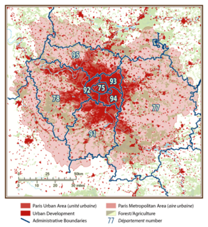
The city of Paris had a population of 2,187,526 people within its administrative city limits as of January 1, 2017. It is surrounded by the Paris unité urbaine, or urban area, the most populous urban area in the European Union. In 2017 the unité urbaine had a population of 10,784,830. The Paris Region, or Île-de-France covers 12,012 square kilometers, and has its own regional council and president. It has a population of 14,365,473 as of January 2021, or 21.4 percent of the population of France.

Auvergne is a former administrative region in central France, comprising the four departments of Allier, Puy-de-Dôme, Cantal and Haute-Loire. Since 1 January 2016, it has been part of the new region Auvergne-Rhône-Alpes.

Mamoudzou is the capital of Mayotte, overseas region and department in the Indian Ocean. Mamoudzou is the most populated commune (municipality) of Mayotte. It is located on Grande-Terre, the main island of Mayotte.

The arrondissement of Yssingeaux is an arrondissement of France in the Haute-Loire departement in the Auvergne-Rhône-Alpes region. It has 44 communes. Its population is 85,073 (2016), and its area is 1,159.7 km2 (447.8 sq mi).

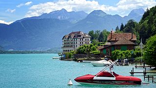
Saint-Galmier is a city in eastern France. It is a communes in Loire department, and belongs to the arrondissement of Montbrison. Saint-Galmier covers an area of 19.5 square kilometers. As of January 1, 2018, it had a population of 5,737, ranking 1,903th among French communes.
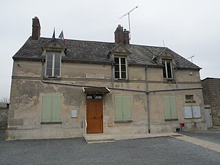
Crouy-en-Thelle is a commune in the Oise department in northern France.
Overseas France consists of thirteen French-administered territories outside Europe, mostly the remains of the French colonial empire that chose to remain a part of the French state under various statuses after decolonization. This collective name is used in everyday life in France but is not an administrative designation in its own right. Indeed, the five overseas regions have exactly the same administrative status as the metropolitan regions while the five overseas collectivities are semi-autonomous and New Caledonia is an autonomous territory. Overseas France includes island territories in the Atlantic, Pacific and Indian Oceans, French Guiana on the South American continent, and several peri-Antarctic islands as well as a claim in Antarctica. Excluding the district of Adélie Land, where French sovereignty is effective de jure by French law, but where the French exclusive claim on this part of Antarctica is frozen by the Antarctic Treaty, overseas France covers a land area of 119,396 km2 (46,099 sq mi) and accounts for 18.0% of the French Republic's land territory. Its exclusive economic zone (EEZ) of 9,825,538 km2 (3,793,661 sq mi) accounts for 96.7% of the EEZ of the French Republic.
Auvergne-Rhône-Alpes is a region in southeast-central France created by the 2014 territorial reform of French regions; it resulted from the merger of Auvergne and Rhône-Alpes. The new region came into effect on 1 January 2016, after the regional elections in December 2015.

Bourgogne-Franche-Comté is a region in Eastern France created by the 2014 territorial reform of French regions, from a merger of Burgundy and Franche-Comté. The new region came into existence on 1 January 2016, after the regional elections of December 2015, electing 100 members to the Regional Council of Bourgogne-Franche-Comté.

Normandy is the northwesternmost of the eighteen regions of France, roughly coextensive with the historical Duchy of Normandy.