Paraguay, officially the Republic of Paraguay, is a landlocked country in South America. It is bordered by Argentina to the south and southwest, Brazil to the east and northeast, and Bolivia to the northwest. It has a population of around 6.1 million, nearly 2.3 million of whom live in the capital and largest city of Asunción, and its surrounding metro area.
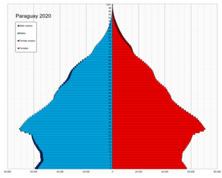
Demographic features of the population of Paraguay include population density, ethnicity, education level, health of the populace, economic status, religious affiliations and other aspects of the population.
Atlántida is a department located on the north Caribbean shore of Honduras, Central America. The capital is the port city of La Ceiba.

Tarija is a department in Bolivia. It is located in south-eastern Bolivia bordering with Argentina to the south and Paraguay to the east. According to the 2012 census, it has a population of 482,196 inhabitants. It has an area of 37,623 km2 (14,526 sq mi). The city of Tarija is the capital of the department.

Sistan and Baluchestan province or Asli Baluchestan is the second largest province of the 31 provinces of Iran, after Kerman province, with an area of 180,726 km2. It is in the southeast of the country, bordering Afghanistan and Pakistan, and its capital is the city of Zahedan.

Yazd province is one of the 31 provinces of Iran. It is in the center of the country, and its capital is the city of Yazd. In 2014, it was placed in Region 5. The province has an area of 76,469 km2.
Damietta Governorate is one of the 27 governorates of Egypt. It is located in the northeastern part of the country, and has a population of over 1.3 million. The capital is the city of Damietta.

Chin State is a state in western Myanmar. Chin State is bordered by Sagaing Division and Magway Division to the east, Rakhine State to the south, the Chittagong Division of Bangladesh to the west, and the Indian states of Mizoram to the west and Manipur to the north. The population of Chin State is about 488,801 according to the 2014 census, and its capital city is Hakha.

The Central Federal District is one of the eight federal districts of Russia. Geographically, the district is situated in the extreme west of present-day Russia; although it can be considered as the central region of European Russia. The district covers an area of 650,200 square kilometers (251,000 sq mi), and recorded a population of 40,334,532 in the 2021 Census. The Presidential Envoy to the Central Federal District is Igor Shchyogolev.

Santa Cruz is the largest of the nine constituent departments of Bolivia, occupying about one-third (33.74%) of the country's territory. With an area of 370,621 km2 (143,098 sq mi), it is slightly smaller than Japan or the US state of Montana. It is located in the eastern part of the country, sharing borders in the north and east with Brazil and with Paraguay in the south.

West Darfur State is one of the states of Sudan, and one of five comprising the Darfur region. Prior to the creation of two new states in January 2012, it had an area of 79,460 km² and an estimated population of approximately 1,775,945 in 2018. It borders North and Central Darfur to the east. The Chadian prefectures of Biltine and Ouaddaï lie to the west, while to the north is the prefecture of Bourkou-Ennedi-Tibesti. Al-Junaynah is the capital of the state. West Darfur has been the site of much of the Darfur conflict.
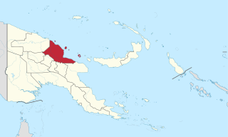
Madang is a province of Papua New Guinea. The province is on the northern coast of mainland Papua New Guinea and has many of the country's highest peaks, active volcanoes and its biggest mix of languages. The capital is the town of Madang.

Chimbu, more frequently spelled Simbu, is a province in the Highlands Region of Papua New Guinea. The province has an area of 6,112 km2 and a population of 376,473. The capital of the province is Kundiawa. Mount Wilhelm, the tallest mountain in Papua New Guinea is on the border of Eastern part of Simbu and the Western part of Madang Province.

Gulf Province is a province of Papua New Guinea located on the southern coast. The provincial capital is Kerema. The 34,472 km2 province is dominated by mountains, lowland river deltas, and grassland flood plains. In Gulf Province, the Kikori, Turama, Purari, and Vailala rivers meet the Papuan Gulf. The province has the second-smallest population of all the provinces of Papua New Guinea with 106,898 inhabitants. The province shares land borders with Western Province to the west, Southern Highlands, Chimbu, and Eastern Highlands to the north, Morobe Province to the east, and Central Province to the southeast.

Eastern Highlands is a highlands province of Papua New Guinea. The provincial capital is Goroka. The province covers an area of 11,157 km², and has a population of 579,825. The province shares a common administrative boundary with Madang Province to the north, Morobe Province to the east, Gulf Province to the south, and Simbu Province to the west. The province is the home of the Asaro mud mask that is displayed at shows and festivals within the province and in the country. The province is reachable by air, including Goroka Airport, and road transport, including the main Highlands Highway.

Central Province is a province in Papua New Guinea located on the southern coast of the country. It has a population of 237,016 people and is 29,998 square kilometres (11,582 sq mi) in size. The seat of government of Central Province, which is located within the National Capital District outside the province, is the Port Moresby suburb of Konedobu. On 9 October 2007, the Central Province government announced plans to build a new provincial capital city at Bautama, which lies within Central Province near Port Moresby, although there has been little progress in constructing it.
Shariatpur is a district in the Dhaka Division of central Bangladesh.