Rathen, Aberdeenshire

Last updated

Rathen
Cottage and kirk, Rathen (geograph 6597583).jpg
Rathen Kirk and adjacent but and ben
Aberdeenshire UK location map.svg
Red pog.svg
Rathen
Location within Aberdeenshire
OS grid reference NK000607
Council area
Lieutenancy area
Country Scotland
Sovereign state United Kingdom
Post town FRASERBURGH
Postcode district AB43
Dialling code 01346
Police Scotland
Fire Scottish
Ambulance Scottish
UK Parliament
Scottish Parliament
List of places
UK
Scotland
57°38′00″N2°00′07″W / 57.63338°N 2.00198°W / 57.63338; -2.00198

Rathen is a parish and hamlet near Fraserburgh, Aberdeenshire, Scotland. In Scottish Gaelic, its name means fort on the river. [1]

Contents

On the coast is Cairnbulg Point, flanking the eastern side of Fraserburgh Bay. [1] Mormond Hill (769 feet (234 m)) sits on the borders of Rathen, Strichen and Lonmay. [1] Rathen Burn runs through the parish for three miles. [1]

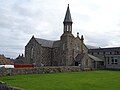
The old kirk, St Ethernan's, [2] is one of the most ancient in Aberdeenshire. The church was given, by Marjory, Countess of Buchan, to Arbroath Abbey in the 13th century. [1] In 1328, Robert the Bruce, a year before his death, granted it to the college and canons of Old Machar. [1] A sundial was added in the kirkyard in 1625, [2] and the church's nave was erected by the Frasers of Memsie in 1646. [1] While the belfry dates from 1782, its bell has the inscription Peter Jansen, 1643. [1] Also in the kirkyard are the burials of the great great grandparents of the Norwegian composer Edvard Grieg. [2]

The church was replaced in 1868 by a new construction, designed by William Smith, [2] to the east of its predecessor. [1]

There is also a free church, Inverallochy and Rathen East Church, [3] two miles northeast of Rathen. [4]

At the end of the 19th century, the main residence was Mormond House (formerly Cortese House), [2] with House of Memsie being used as a farmhouse. [1]

Rathen railway station formerly existed as part of the now-defunct Formartine and Buchan Railway.

Related Research Articles

<span class="mw-page-title-main">Portsoy</span> Port village in Aberdeenshire, Scotland

Portsoy is a village in Aberdeenshire, Scotland. Historically, Portsoy was in Banffshire. The original name may come from Port Saoithe, meaning "saithe harbour". Portsoy is located on the Moray Firth coast of northeast Scotland, 50 miles (80 km) northwest of Aberdeen and 65 miles (105 km) east of Inverness. It had a population of 1,752 at the time of the 2011 census.

<span class="mw-page-title-main">Rosehearty</span> Human settlement in Scotland

Rosehearty is a settlement on the Moray Firth coast, four miles west of the town Fraserburgh, in the historical county of Aberdeenshire in Scotland. The burgh has a population of approximately 1,300 with about 25 per cent of pensionable age.

<span class="mw-page-title-main">Aberchirder</span> Human settlement in Scotland

Aberchirder known locally as Foggieloan or Foggie, is a village in Aberdeenshire, Scotland, situated on the A97 road six miles west of Turriff.

<span class="mw-page-title-main">Gardenstown</span> Human settlement in Scotland

Gardenstown is a small coastal village, 8.7 miles (14.0 km) by road east of Banff in Aberdeenshire, northeastern Scotland.

<span class="mw-page-title-main">Lonmay</span>

Lonmay is a village and parish in the Buchan area of Aberdeenshire, Scotland. It lies along the A90 road, between Peterhead and Fraserburgh, near to the junction with the A952 road at Cortes. The parish, formerly known as St Colms, encompasses the villages of St Combs and Crimond, as well as the village of Lonmay. It had a station on the Formartine and Buchan Railway, but this closed in 1965. The present Lonmay Kirk dates from 1786.

<span class="mw-page-title-main">Mormond Hill</span> Hill in Aberdeenshire, Scotland

Mormond Hill is a large hill in Aberdeenshire, Scotland, not far from Fraserburgh. Its peak is 769 feet (234 m). The villages of Strichen and New Leeds can be found at its southern foothills.

<span class="mw-page-title-main">Sandhaven</span> Human settlement in Scotland

Sandhaven is a small fishing village in Aberdeenshire, Scotland, which lies between Rosehearty to the west and Fraserburgh to the east. It is joined to the even smaller village of Pitullie to the west.

<span class="mw-page-title-main">Rathen railway station</span> Disused railway station in Rathen, Aberdeenshire

Rathen railway station was a railway station in Rathen, Aberdeenshire, on the defunct Formartine and Buchan Railway in northeast Scotland.

Memsie, Aberdeenshire, is a small community near Fraserburgh, Scotland. On Memsie Moor there is a very large stone cairn, Memsie Cairn, which has been opened, but nothing found inside. There were two other cairns, but they have been removed. Apart from the cairn, Memsie is near Mormond Hill, which was a very large listening post in the Cold War. These days the former listening post is used for satellite communications. The nearest Kirk to Memsie is in Rathen.

<span class="mw-page-title-main">Inverallochy Castle</span>

Inverallochy Castle is a ruined courtyard castle, near the village of Inverallochy in the Buchan area of North-East Scotland, dating to 1504. It lies 0.5 miles (0.80 km) south of Cairnbulg Castle, near Fraserburgh, and formerly stood beside the now-drained Loch of Inverallochy. It was described by W. Douglas Simpson as one of the nine castles of the Knuckle, referring to the rocky headland of North-East Aberdeenshire.

<span class="mw-page-title-main">New Leeds</span> Human settlement in Scotland

New Leeds is a planned village in the Buchan area of Aberdeenshire, Scotland, situated 5.1 kilometres (3.2 mi) east of Strichen at the foot of Mormond Hill.

<span class="mw-page-title-main">Cortes, Aberdeenshire</span> Human settlement in Scotland

Cortes is a rural settlement in the Banff and Buchan area of Aberdeenshire, Scotland, situated in the parish of Rathen, 7.8 kilometres (4.8 mi) south of Fraserburgh.

<span class="mw-page-title-main">Caputh, Perth and Kinross</span> Human settlement in Scotland

Caputh is a parish and village in Perth and Kinross, Scotland. It lies on the A984 Coupar Angus-to-Dunkeld road, about 6 miles southeast of Dunkeld and 8 miles west of Coupar Angus.

<span class="mw-page-title-main">Pitsligo</span> Human settlement in Scotland

Pitsligo was a coastal parish in the historic county of Aberdeenshire, Scotland, containing the fishing villages of Rosehearty, Pittulie and Sandhaven, 3 miles west of Fraserburgh and 12 miles north of Mintlaw.

<span class="mw-page-title-main">High Kirk, Dunoon</span> Church in Scotland

High Kirk, also known as the Old Parish Church, is a Church of Scotland church building in Dunoon, Argyll and Bute, Scotland. It is located on Kirk Street, just south of the town centre. Constructed in the Gothic revival style, it is a Category B listed building. The High Kirk is scheduled for closure. Its final service was held on 1 October 2023.

<span class="mw-page-title-main">House of Memsie</span> Category A listed house in Memsie, Aberdeenshire

House of Memsie is a Category A listed country house and estate in Memsie, Aberdeenshire, Scotland. It dates to around 1760, and it received its historic designation in 1971. It was formerly the home of the Fraser family for over three hundred years. It was sold to Lord Saltoun in the early 19th century. A Captain Dalrymple was another previous owner. Historian Charles McKean describes it as a "smaller and more decorative version of Aberdour House".

<span class="mw-page-title-main">Kinfauns Parish Church</span> Church in Scotland, Scotland

Kinfauns Parish Church is a Church of Scotland church in Kinfauns, Perth and Kinross, Scotland. Dating to 1869, the work of architect Andrew Heiton and John Murray Robertson, it is now a Category C listed building.

<span class="mw-page-title-main">Ballantine and Gardiner</span>

Ballantine and Gardiner was a Scottish manufacturer of stained-glass windows, one of several names the company worked under.

<span class="mw-page-title-main">St John's Place</span> Prominent street in Perth, Scotland

St John's Place is an ancient street in the city of Perth, Scotland, located a short distance southeast of the city centre. Today it runs for about 500 feet (170 yd) between King Edward Street to the west and St John Street to the east; it is now markedly smaller than when it was originally laid out, due to the construction of both Perth City Hall in 1914 and of St John's Shopping Centre in 1987, both in King Edward Street at the western end. The latter construction also saw the loss of the short-lived St John's Square, which was created in the 1960s. There is also a South St John Street, while North St John Street existed in the early 20th century.

<i>Ordnance Gazetteer of Scotland: A Graphic and Accurate Description of Every Place in Scotland</i> A historical publication by Francis Hines Groome, 1851–1902

Ordnance Gazetteer of Scotland: A Graphic and Accurate Description of Every Place in Scotland is a book by Francis Hindes Groome. It was published in 1901, by T. C. and E. C. Jack of Edinburgh, combining six volumes written between 1884 and 1885, along with initial revisions made in 1895 and subsequent smaller revisions. It has entries for all of Scotland's cities, towns, villages and hamlets, beginning with Aven in today's Aberdeenshire and concluding with Zetland, the former name of Shetland. It also includes tourist attractions, historical sites and the histories of family names and clans.

References

  1. 1 2 3 4 5 6 7 8 9 10 Ordnance Gazetteer of Scotland: A Graphic and Accurate Description of Every Place in Scotland, Frances Hindes Groome (1901), p. 1363
  2. 1 2 3 4 5 McKean, Charles (1990). Banff & Buchan: An Illustrated Architectural Guide. Mainstream Publications Ltd. p. 137. ISBN   185158-231-2.
  3. Inverallochy and Rathen East Church official website
  4. Ordnance Gazetteer of Scotland: A Graphic and Accurate Description of Every Place in Scotland, Frances Hindes Groome (1901), p. 1364