Red Line (Dallas Area Rapid Transit)

Last updated

Red Line
DART Red Line bullet.svg
Richardson August 2019 26 (Galatyn Park Station).jpg
Northbound Red Line train at Galatyn Park Station
Overview
Owner DART
Locale Dallas, Texas
Termini
Stations25
Service
Type Light rail
System DART Light Rail
Operator(s)DART
History
OpenedJune 14, 1996
Technical
Line length27.7 mi (44.6 km)
Track gauge 4 ft 8+12 in (1,435 mm)
Electrification Overhead catenary
Highest elevationAt grade, elevated, underground
Route map
Red Line (Dallas Area Rapid Transit)
BSicon tKSTRa carrot.svg
BSicon lHST red.svg
BSicon KSTRa red.svg
Parker Road
Centro other car parking large.svg
BSicon tSTR carrot.svg
BSicon lHST red.svg
BSicon STR red.svg
Downtown Plano
BSicon exSTR+l.svg
BSicon STR red.svg
BSicon etINT carrot.svg
BSicon exSTRq.svg
BSicon exCONTfq.svg
12th Street (planned)
BSicon exSKRZ-G4hl.svg
BSicon SKRZ-G4hr red.svg
BSicon exINT-L.svg
BSicon STR red.svg
BSicon tSTR carrot.svg
BSicon lHST red.svg
BSicon exlINT-R.svg
CityLine/Bush
Centro other car parking large.svg
BSicon exCONTf.svg
BSicon tSTR carrot.svg
BSicon STR red.svg
BSicon tSTR carrot.svg
BSicon lHST red.svg
BSicon STR red.svg
Galatyn Park
BSicon tSTR carrot.svg
BSicon lHST red.svg
BSicon STR red.svg
Arapaho Center
Centro other car parking large.svg
BSicon STR red.svg
BSicon tSTR carrot.svg
BSicon lHST red.svg
BSicon lhSTRae.svg
Spring Valley
Centro other car parking large.svg
BSicon SKRZ-G4u red.svg
BSicon tSTR carrot+GRZq.svg
BSicon STR red.svg
Arrow Blue Up 001.svg Orange Line service peak hours only
Arrow Blue Down 001.svg Orange Line normal service
BSicon tSTR carrot.svg
BSicon lHST red.svg
BSicon STR red.svg
LBJ/Central
Centro other car parking large.svg
BSicon STR red.svg
BSicon tSTR carrot.svg
BSicon lHST red.svg
BSicon lhSTRa@g.svg
Forest Lane
Centro other car parking large.svg
BSicon tbSTR carrot.svg
BSicon hbKRZW red.svg
BSicon STR red.svg
BSicon tSTR carrot.svg
BSicon lHST red.svg
BSicon lhSTR.svg
Walnut Hill
Centro other car parking large.svg
BSicon STR red.svg
BSicon tSTR carrot.svg
BSicon lHST red.svg
BSicon lhSTRe@f.svg
Park Lane
Centro other car parking large.svg
BSicon tSTR carrot.svg
BSicon lHST red.svg
BSicon STR red.svg
Lovers Lane
BSicon STR red.svg
BSicon tSTR carrot.svg
BSicon tSTR+l cerulean.svg
BSicon STR+l cerulean.svg
BSicon CONTfq cerulean.svg
BSicon tSTR carrot.svg
BSicon lHST red.svg
BSicon STR red.svg
SMU/Mockingbird
Centro other car parking large.svg
BSicon tINTae red.svg
Cityplace/Uptown
M-Line Trolley logo.svg
BSicon STR red.svg
BSicon ftSTR+l.svg
BSicon fSTR+l.svg
BSicon fCONTfq.svg
BSicon tINT black.svg
BSicon STR red.svg
Pearl/Arts District
BSicon BUS2.svg
BSicon tINT black.svg
BSicon STR red.svg
St. Paul
M-Line Trolley logo.svg
BSicon tSTR black.svg
BSicon lHST red.svg
BSicon STR red.svg
Akard
BSicon tINT black.svg
BSicon STR red.svg
West End
BSicon BUS2.svg
BSicon ftCONTgq.svg
BSicon CONTgq carrot.svg
BSicon tSTR cerulean.svg
BSicon tSTRr black.svg
BSicon STRr carrot.svg
BSicon ftSTRr.svg
BSicon STR red.svg
BSicon dCONTgq.svg
BSicon STR~L red.svg
BSicon tSTR~L cerulean.svg
BSicon STR+r.svg
BSicon tSTR~R cerulean.svg
BSicon STR~R red.svg
BSicon dKINTe-L.svg
BSicon tdSTR cerulean.svg
BSicon ldINT-R.svg
BSicon dSTR red.svg
BSicon udKHSTa.svg
Union Station Dallas Streetcar Icon.png TRE logo.png BSicon LOGO Amtrak2.svg
BSicon uCONTgq.svg
BSicon mKRZu red+u.svg
BSicon uSTRr.svg
Dallas Streetcar
to Bishop Arts
BSicon tSTR cerulean.svg
BSicon lHST red.svg
BSicon STR red.svg
Convention Center
BSicon tSTR cerulean.svg
BSicon SKRZ-G4o red.svg
BSicon tSTR cerulean.svg
BSicon lHST red.svg
BSicon STR red.svg
Cedars
BSicon STR red.svg
BSicon tSTR cerulean.svg
BSicon uABZl+l.svg
BSicon uKDSTeq.svg
Central Rail Operating Facility
BSicon tbSTR cerulean.svg
BSicon hbKRZWae red.svg
BSicon tSTR cerulean.svg
BSicon lHST red.svg
BSicon STR red.svg
8th & Corinth
Centro other car parking large.svg
BSicon STR red.svg
BSicon tSTRl cerulean.svg
BSicon STRl cerulean.svg
BSicon CONTfq cerulean.svg
BSicon HST red.svg
Dallas Zoo
BSicon HST red.svg
Tyler/Vernon
BSicon HST red.svg
Hampton
Centro other car parking large.svg
BSicon KHSTe red.svg
Westmoreland
Centro other car parking large.svg
BSicon tSTRq carrot.svg
BSicon STRq red.svg
Other service sharing track
BSicon tSTRq black.svg
BSicon STRq red.svg
Multiple services sharing track with Red Line

Wheelchair symbol.svg All stations are accessible

The Red Line is a light rail line in Dallas, Texas operated by the Dallas Area Rapid Transit system. It began operations in June 1996, and is one of two inaugural light rail lines in the DART Light Rail system alongside the Blue Line.

Contents

Route

Westmoreland to Downtown

The southwestern terminus of the Red Line is at Westmoreland Station in southwest Dallas at the intersection of Illinois Avenue and Westmoreland Road. The southwestern part of the Red Line runs on a private right-of-way with grade crossings. Just before 8th & Corinth, the line merges with the Blue Line. The joint Red and Blue Line tracks then rise on to a viaduct that crosses Cedar Creek, the Trinity River, and a freight railroad line. At Lamar Street, the line turns north at a wye where a pair of tracks leading to one of two train yards on the system diverges. The Red and Blue Lines continue north, crossing the Landry Freeway, travelling under the Dallas Convention Center and stop at Dallas Union Station. After crossing over Main Street, the lines turn east as they merge with the Green Line and Orange Line and enter downtown Dallas. At this point, the lines leave their right of ways and operate on a dedicated street-running right of way.

Downtown to Parker Road

The four DART lines share a common section of track through downtown, with four stops: West End, Akard Street, St. Paul Street and Pearl Street.

After Pearl Street, street running ends and the lines return to private right-of-ways. The four lines diverge at a wye, with the Green Line diverging to the southeast while the Red, Blue and Orange Lines turn north, cross the Good-Latimer Expressway at grade, and descend into a long tunnel under the Central Expressway (US 75), with a stop at Cityplace. The lines exit the tunnel at Mockingbird. The Blue Line diverges from the Red Line and heads east, while the Red and Orange Lines turn north.

The Red Line then travels through north Dallas, Richardson and Plano. Most of the line runs at grade level with grade crossings, although portions of the route run on elevated viaducts. The line terminates at the Parker Road Station at Park Boulevard near Central Expressway in Collin County.

History

Much of the line was constructed on the former Texas Electric Railway route. That service ceased operations in 1948.

The Red Line was part of the initial launch of DART's light rail testing and service in 1996. At the time, the line only ran from Westmoreland Station to Pearl Station in the northeast corner of downtown. In 1997, the Red Line was extended to Park Lane Station, and was the first DART line to use the 3.5-mile twin tunnels. On December 18, 2000, Cityplace Station, the southwest's first commercial subway station was opened along the Red Line underneath Cityplace Tower in the tunnel under the Central Expressway.

In 2002, the Red Line extended into Richardson, ending at Galatyn Park Station, extending the light rail service 9 miles (14.5 km) over its original length. Later that year, the line was opened to the Parker Road Station, an additional 3 miles (4.8 km) of track, its current terminus.

Plans for expansion

DART-owned corridor from Parker Road station to Downtown McKinney for possible future rail service expansion DART Corridor from Plano to McKinney.png
DART-owned corridor from Parker Road station to Downtown McKinney for possible future rail service expansion

The current northern terminus of the Red Line is Parker Road station in Plano. The further north suburb, Allen, is eligible to join DART. However, active Red line service is unable to expand further north because Allen is currently unable to levy the 1% sales tax required for DART membership. [1]

The North Central Texas Council of Governments (NCTCOG) in a 2022 meeting discussed the possibility of expansion of the Red Line corridor from Plano through Allen to McKinney. Either the Red Line or the Silver Line could be extended north. The study proposed seven stations between the current Parker Road Station and the hypothetical northern terminus Downtown McKinney Station. The extension would be 18 miles long, cost between $700 million and $900 million to construct, and is estimated to have 7,000 to 8,000 riders a day by 2045. [2]

Stations

Daily Service

Listed from north to south
StationOther linesOpenedNotes
Parker Road     (Rush Hour only)December 9, 2002Terminus for Red and Orange Lines (Orange Line During peak-hour only)
Downtown Plano
CityLine/Bush Formerly Bush Turnpike Station until March 14, 2016. Planned Silver Line transfer station
Galatyn Park July 1, 2002
Arapaho Center
Spring Valley
LBJ/Central     Terminus for Orange Line outside peak hours
Forest Lane
Walnut Hill
Park Lane January 10, 1997
Lovers Lane
SMU/Mockingbird         Northernmost transfer for the Blue Line
Cityplace/Uptown December 18, 2000Transfer to M-Line Trolley logo.svg M-Line Trolley
Pearl/Arts District             June 14, 1996Easternmost transfer for Green Line
St. Paul Transfer to M-Line Trolley logo.svg M-Line Trolley (one block north)
Akard
West End Westernmost transfer station for the Orange Line and Green Line
EBJ Union Station     Transfer to Dallas Streetcar Icon.png Dallas Streetcar, TRE logo.png Trinity Railway Express, and BSicon LOGO Amtrak2.svg Amtrak
Convention Center
Cedars
8th & Corinth Southernmost transfer for the Blue Line
Dallas Zoo
Tyler/Vernon
Hampton
Westmoreland

Special Event Service

Related Research Articles

<span class="mw-page-title-main">Dallas Area Rapid Transit</span> American transit agency

Dallas Area Rapid Transit (DART) is a transit agency serving the Dallas–Fort Worth metroplex of Texas. It operates buses, light rail, commuter rail, and high-occupancy vehicle lanes in Dallas and twelve of its suburbs. In 2023, the system had a ridership of 50,463,300, or about 166,900 per weekday as of the fourth quarter of 2023.

<span class="mw-page-title-main">Blue Line (Dallas Area Rapid Transit)</span> Light rail line in the Dallas-Fort Worth Metroplex

The Blue Line is a light rail line in the system of mass transit in Dallas, Texas (USA), operated by the Dallas Area Rapid Transit system. Along with the Red Line, it is one of the original modern rail lines in Dallas.

<span class="mw-page-title-main">Green Line (Dallas Area Rapid Transit)</span> Light rail line in the Dallas-Fort Worth Metroplex

The Green Line is a 28.6-mile (46.0 km) light rail line in Dallas, United States, operated by the Dallas Area Rapid Transit authority (DART). The US$1.7 billion project opened in phases, starting in 2009. It operates in addition to the Blue, Red, and Orange lines.

<span class="mw-page-title-main">Parker Road station</span> DART Light Rail station in Plano, Texas

Parker Road station is an intermodal transit facility in Plano, Texas. The station is located near the intersection of Parker Road (FM 544) and North Central Expressway (US 75). Operated by Dallas Area Rapid Transit, the station services DART Light Rail, three bus routes, and four on-demand service zones.

<span class="mw-page-title-main">Galatyn Park station</span> DART Light Rail station in Richardson, Texas

Galatyn Park station is a DART Light Rail station in Richardson, Texas. The station serves the Red Line and, during peak periods, the Orange Line. It is located on the eastern side of North Central Expressway (US-75) and is named for a nearby road, Galatyn Parkway.

<span class="mw-page-title-main">SMU/Mockingbird station</span> DART light rail station

SMU/Mockingbird station is a DART Light Rail station in Dallas, Texas. It is located at Mockingbird Lane and North Central Expressway in North Dallas. It opened in January 1997 and is a station on the Blue, Red, and Orange Lines, serving the Mockingbird Station mixed-use development and nearby Southern Methodist University (SMU).

<span class="mw-page-title-main">Cityplace/Uptown station</span> DART light rail station in Dallas, Texas

Cityplace/Uptown station is a DART Light Rail station located in Dallas, Texas. It is located beneath North Central Expressway at Haskell Avenue in the Cityplace district. As the first infill DART station, it opened on December 18, 2000, as the first public subway station in Texas.

<span class="mw-page-title-main">Pearl/Arts District station</span> DART light rail station in Dallas, Texas

Pearl Street/Arts District station is a DART Light Rail station located in Dallas, Texas. It is located on Bryan Street, east of Pearl Street, in the City Center District. It opened June 14, 1996, and is the easternmost station on the trunk line segment shared by the Red, Blue, Green and Orange Lines, serving the Plaza of the Americas, the Sheraton Dallas Hotel, 2001 Bryan Tower, the San Jacinto Tower, the Morton H. Meyerson Symphony Center and JPMorgan Chase Tower.

<span class="mw-page-title-main">Oak Lawn, Dallas</span> Place in Texas, United States

Oak Lawn is a neighborhood in Dallas, Texas, defined in Dallas City Ordinance 21859 as Planned Development District No. 193, the Oak Lawn Special Purpose District. The unofficial boundaries are Turtle Creek Boulevard, Central Expressway, the City of Highland Park, Inwood Road, and Harry Hines Boulevard. It is over 12 square miles (31 km2) in area. Officially it is bounded by the City of Highland Park, the North Central Expressway, Stemmons Freeway, Woodall Rodgers Freeway, and other roads. The district is within the boundary defined by the City of Dallas law, excluding any existing planned development districts within.

<span class="mw-page-title-main">Orange Line (Dallas Area Rapid Transit)</span> Light rail line in the Dallas-Fort Worth Metroplex

The Orange Line is a 37-mile (60 km) light rail line in the Dallas, Texas metropolitan area. The line is operated by Dallas Area Rapid Transit as a part of its DART Light Rail system. It is the only east-west line in the system.

<span class="mw-page-title-main">Cityplace, Dallas</span> Place in Texas, United States

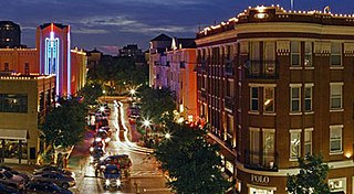
Cityplace is a TIF District and neighborhood in Old East Dallas, Texas (USA) - near the Uptown area of Dallas, adjacent to the intersection of Central Expressway and Haskell Avenue/Blackburn Street. East of Central Expressway, the neighborhood includes the tree-lined Haskell boulevard and travels past the 42-story Tower at Cityplace. At 42-stories, it is the tallest building in Dallas outside downtown. Also on the east is the newer Cityville high-end apartment complex. The west side Cityplace includes the new-urbanist West Village and the northern end of the Uptown neighborhood.

<span class="mw-page-title-main">West Village, Dallas</span>

The West Village District is a walkable urban village in the Uptown area of Dallas, Texas. West Village is located at the northern edge of Uptown along McKinney Avenue and is bordered by Lemmon Avenue, Cole Avenue, Haskell Drive and Central Expressway.

This article is about transportation systems in and around Dallas, Texas (USA).

Knox–Henderson Station was a proposed subway station along the Dallas Area Rapid Transit Light Rail in the Knox-Henderson neighborhood of Dallas, Texas. It would serve the Red, Blue, and Orange Lines located beneath the North Central Expressway at Willis Avenue.

The Silver Line, also known as the Cotton Belt Rail Line, is an under construction 26-mile (42 km) hybrid rail line traversing Collin, Dallas, and Tarrant Counties in the U.S. state of Texas operated by Dallas Area Rapid Transit (DART). The line will provide service from Dallas's northeast suburbs of Plano, Richardson, and Addison to Dallas/Fort Worth International Airport Terminal B.

<span class="mw-page-title-main">Victory station</span> Mass transit station in Dallas, Texas

Victory station is a mass transit station in Dallas, Texas, United States. It serves Trinity Railway Express commuter rail line, DART Light Rail trains, and DART buses. Located along the Stemmons Corridor in the Uptown neighborhood, the station opened in 2001 in the Victory Park development as a temporary platform shortly after the opening of the American Airlines Center.

<span class="mw-page-title-main">DART Light Rail</span> Light rail system in the Dallas-Fort Worth Metroplex

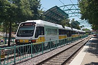
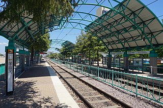
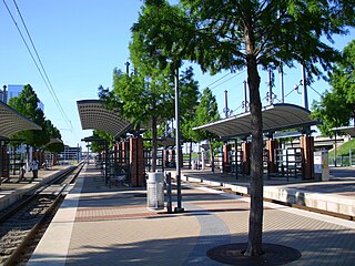
DART Light Rail is the light rail system serving the metropolitan area of Dallas, Texas and is owned and operated by Dallas Area Rapid Transit (DART). The DART Light Rail system opened June 14, 1996 and serves 65 stations and four lines, covering 93 miles (149.7 km): the Blue Line, the Red Line, the Green Line, and the Orange Line.

<span class="mw-page-title-main">Uptown, Dallas</span> Place in Texas, United States

Uptown is a PID and a dense neighborhood in Dallas, Texas. Uptown is north of and adjacent to downtown Dallas, and is bordered by US 75 on the east, N Haskell Avenue on the northeast, the Katy Trail on the northwest, Bookhout Street and Cedar Springs Road on the west, N Akard Street on the southwest and Spur 366 on the south.

<span class="mw-page-title-main">D2 Subway</span> Proposed light rail expansion in Dallas, Texas, US

D2 Subway is a proposed 2.4 mi (3.9 km) expansion of the DART Light Rail system in metropolitan Dallas, Texas, in the United States. The subway would run from the existing Victory station, tunneling underground through the city centre of downtown Dallas, and connect to the existing tunnel under Cityplace. Four new stations would be built along the new alignment.

References

  1. "Public Transit". Allen, Texas. Archived from the original on April 9, 2024. Retrieved April 9, 2024.
  2. Pirayesh, Erick (February 17, 2022). "Regional Transportation Council looks to extend DART rail line from Plano to McKinney". Community Impact. Community Impact Newspaper. Archived from the original on August 18, 2023.
Template:Attached KML/Red Line (Dallas Area Rapid Transit)
KML is from Wikidata