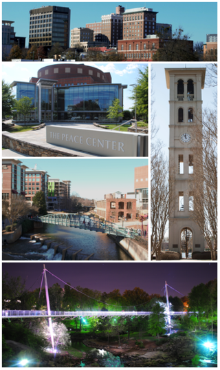
Greenville is a city in and the seat of Greenville County, South Carolina, United States. With a population of 70,720 at the 2020 census, it is the sixth-most populous city in the state. Greenville is located approximately halfway between Atlanta, Georgia, and Charlotte, North Carolina, along Interstate 85. Its metropolitan area also includes Interstates 185 and 385. Greenville is the anchor city of the Upstate, a combined statistical area with a population of 1,487,610 at the 2020 census. Greenville was the fourth fastest-growing city in the United States between 2015 and 2016, according to the U.S. Census Bureau.

The East Coast Greenway is a 3,000-mile (4,800 km) pedestrian and bicycle route between Maine and Florida along the East Coast of the United States. The nonprofit East Coast Greenway Alliance was created in 1991 with the goal to use the entire route with off-road, shared-use paths; as of 2021, over 1,000 mi (1,600 km) of the route (35%) meets this criteria. In 2020, the Greenway received over 50 million visits.

William B. Umstead State Park is a North Carolina state park in Wake County, North Carolina in the United States. It covers 5,599 acres (22.66 km2) nestled between the expanding cities of Raleigh, Cary, and Durham, North Carolina. It offers hiking, bridle, and bike trails, boat rentals, camping, picnic areas, and educational programs.

The Reedy River is a tributary of the Saluda River, about 65 miles (105 km) long, in northwestern South Carolina in the United States. Via the Saluda and Congaree rivers, it is part of the watershed of the Santee River, which flows to the Atlantic Ocean.

Falls Park on the Reedy is a 32-acre (130,000 m2) park adjacent to downtown Greenville, South Carolina in the historic West End district. Considered the birthplace of Greenville, the park was founded in 1967 when the Carolina Foothills Garden Club reclaimed 26 acres (110,000 m2) of land that had been previously used by textile mills. Renovation accelerated in the late 1990s under Mayor Knox H. White, prompting the formation of the Falls Park Endowment, a private charity supporting ongoing development. Each summer the park is home to the Upstate Shakespeare Festival.

Poinsett Bridge is the oldest bridge in South Carolina and perhaps in the entire southeastern United States. Named for Joel Roberts Poinsett, it was built in 1820 as part of a road from Columbia, South Carolina, to Saluda Mountain. The stone bridge, which includes a 14-foot (4.3 m) Gothic arch and stretches 130 feet (40 m) over Little Gap Creek, may have been designed by Robert Mills, architect of the Washington Monument. Though no longer in use, the bridge remains largely intact and is part of the 120-acre (48.6 ha) Poinsett Bridge Heritage Preserve. There is a nature trail a few hundred yards from the bridge. The bridge, about which ghost stories have been told for decades, is located off U.S. Highway 25 north of Greenville, South Carolina. The bridge was added to the National Register of Historic Places in 1970.

This list is of the properties and historic districts which are designated on the National Register of Historic Places or that were formerly so designated, in Hennepin County, Minnesota; there are 190 entries as of April 2023. A significant number of these properties are a result of the establishment of Fort Snelling, the development of water power at Saint Anthony Falls, and the thriving city of Minneapolis that developed around the falls. Many historic sites outside the Minneapolis city limits are associated with pioneers who established missions, farms, and schools in areas that are now suburbs in that metropolitan area.

Falls, is an unincorporated community in Wake County, North Carolina, United States, situated on Old Falls of Neuse Road, between Raleigh and Wake Forest, near the Wakefield Plantation development. Falls Dam, on the Neuse River, is within the community.

Paris Mountain State Park is a state park in the U.S. state of South Carolina, located five miles (8 km) north of Greenville. Activities available in the 1,540-acre (6 km2) park include hiking, biking, swimming and picnicking. The 13-acre (52,609 m2) Lake Placid offers swimming and fishing. Canoes, kayaks, and pedal boats are seasonally available for rental; private boats are not permitted. Camping is allowed and campsites range from rustic, back country sites to paved sites with water and electricity hook-ups. The park's Civilian Conservation Corps (CCC) structures, including the Camp Buckhorn lodge, are listed on the National Register of Historic Places. m.

Campbell's Covered Bridge is a wooden covered bridge in northeastern Greenville County, South Carolina, near the small town of Gowensville, and crosses Beaverdam Creek off Pleasant Hill Road.

Reedy River Industrial District runs along Reedy River between River Street and Camperdown Way, in Greenville, South Carolina. It was listed on the National Register of Historic Places in 1979.

Stradley and Barr Dry Goods Store in Greenville, South Carolina was listed on the National Register of Historic Places in 2008.

West End is a neighborhood in Greenville, South Carolina. Located across the Reedy River in downtown, the west end became home to Furman University when it was first established in 1852. The school expanded to fill fifty acres and then moved to its current location northwest of the city in 1958. The Greenville and Columbia Railroad arrived there in 1853, bringing increased commercial activity to the neighborhood that had been first settled in the 1830s.

Downtown Baptist Church, is a historic church building located at 101 W. McBee Avenue in Greenville, South Carolina. It was constructed in 1858 as the new home of First Baptist Church of Greenville, replacing an earlier structure on the banks of the Reedy River. The congregation of First Baptist Church vacated the site for a new campus on Cleveland Street in the late 1970s at which time a minority of the congregation elected to remain at the downtown site and start a new church under the name Downtown Baptist Church.
The South Tar River Greenway is a 3.1 miles (5.0 km) greenway located in Greenville, North Carolina. The northwest terminus trailhead is located at the Town Common. The trail goes east and follows the southern bank of the Tar River, then at the confluence of the Tar River and Green Mill Run, turns south and follows the western edge of the tributary. The southeast terminus trailhead is located at Greensprings Park. This greenway is the second in the city, after the 1.5 miles (2.4 km) Green Mill Run Greenway. The $1,488,000 project is funded from the Federal Highway Administration budget through its inclusion in the Federal FY2005 Appropriations Act.

The Prisma Health Swamp Rabbit Trail is a 19.9-mile (32.0 km) multi-use rail trail in Greenville County, South Carolina, that largely follows the bed of a former railroad that had been nicknamed after the indigenous swamp rabbit. South-to-north the current trail begins at Greenville Technical College, crosses the city of Greenville, proceeds through Falls Park and the campus of Furman University, and ends about a mile north of the Travelers Rest city limits.

Isaqueena, also known as the Gassaway Mansion, is a historic house in Greenville, South Carolina, and the largest private residence in the Upstate. In 1982 it was listed in the National Register of Historic Places.

Conestee Mill is a historic mill in the unincorporated community of Conestee, in Greenville County, South Carolina.

Southern Bleachery and Print Works is a historic factory building in Taylors, Greenville County, South Carolina. Founded by former Furman University English professor Bennette Geer, and built by the J. E. Sirrine Company of Greenville, the mill operated between 1924 and 1965, with the last historic structure being built in 1952. The property consists of 15 contributing resources, including a main building, warehouses, a smokestack, a detached boiler room with smokestack, a filtration plant, and two ponds. The bleachery acquired unfinished goods produced by other textile mills and converted them by bleaching, dyeing, and finishing into material used to manufacture clothing and other items. A small mill village, including Baptist and Methodist churches, was established nearby, and many mill houses continued to exist into the 21st century.

West End Commercial Historic District is a national historic district located at Greenville, South Carolina. It encompasses 15 contributing buildings in Greenville's second "downtown." The commercial buildings primarily date from about 1880 to 1920, and include examples of Victorian commercial architecture. Notable buildings include the American Bank, Alliance and Mills & McBayer Cotton Warehouses, Indian River Fruit Store, Pete's Place, Bacot's West End Drug Store/Stringer's Drug, Furman Lunch, and Greer Thompson Building.


