Regent, North Dakota | |
---|---|
Coordinates: 46°25′20″N102°33′29″W / 46.42222°N 102.55806°W | |
Country | United States |
State | North Dakota |
County | Hettinger |
Founded | 1910 |
Area | |
• Total | 0.56 sq mi (1.45 km2) |
• Land | 0.56 sq mi (1.45 km2) |
• Water | 0.00 sq mi (0.00 km2) |
Elevation | 2,464 ft (751 m) |
Population | |
• Total | 170 |
• Estimate (2022) [4] | 167 |
• Density | 303.57/sq mi (117.25/km2) |
Time zone | UTC-7 (Mountain (MST)) |
• Summer (DST) | UTC-6 (MDT) |
ZIP code | 58650 |
Area code | 701 |
FIPS code | 38-66020 |
GNIS feature ID | 1036234 [2] |
Regent is a city in Hettinger County, North Dakota, United States. The population was 170 at the 2020 census. [3]
Regent was founded in 1910 when the railroad was extended to that point. [5] The city was so named with the aim of promoting its central location in order to attract the county seat. [6] A post office has been in operation at Regent since 1910. [7]
According to the United States Census Bureau, the city has a total area of 0.56 square miles (1.45 km2), all land. [8]
Census | Pop. | Note | %± |
---|---|---|---|
1920 | 262 | — | |
1930 | 308 | 17.6% | |
1940 | 261 | −15.3% | |
1950 | 405 | 55.2% | |
1960 | 388 | −4.2% | |
1970 | 344 | −11.3% | |
1980 | 297 | −13.7% | |
1990 | 268 | −9.8% | |
2000 | 211 | −21.3% | |
2010 | 160 | −24.2% | |
2020 | 170 | 6.3% | |
2022 (est.) | 167 | [4] | −1.8% |
U.S. Decennial Census [9] 2020 Census [3] |
As of the census of 2010, there were 160 people, 80 households, and 47 families residing in the city. The population density was 285.7 inhabitants per square mile (110.3/km2). There were 120 housing units at an average density of 214.3 per square mile (82.7/km2). The racial makeup of the city was 97.5% White, 1.9% Native American, and 0.6% from two or more races.
There were 80 households, of which 16.3% had children under the age of 18 living with them, 50.0% were married couples living together, 7.5% had a female householder with no husband present, 1.3% had a male householder with no wife present, and 41.3% were non-families. 41.3% of all households were made up of individuals, and 21.3% had someone living alone who was 65 years of age or older. The average household size was 2.00 and the average family size was 2.70.
The median age in the city was 52 years. 16.9% of residents were under the age of 18; 4.4% were between the ages of 18 and 24; 16.3% were from 25 to 44; 33.2% were from 45 to 64; and 29.4% were 65 years of age or older. The gender makeup of the city was 51.9% male and 48.1% female.
As of the census of 2000, there were 211 people, 99 households, and 62 families residing in the city. The population density was 385.8 inhabitants per square mile (149.0/km2). There were 126 housing units at an average density of 230.4 per square mile (89.0/km2). The racial makeup of the city was 98.58% White and 1.42% Native American. Hispanic or Latino of any race were 0.47% of the population.
There were 99 households, out of which 21.2% had children under the age of 18 living with them, 53.5% were married couples living together, 8.1% had a female householder with no husband present, and 36.4% were non-families. 36.4% of all households were made up of individuals, and 26.3% had someone living alone who was 65 years of age or older. The average household size was 2.13 and the average family size was 2.75.
In the city, the population was spread out, with 23.2% under the age of 18, 1.9% from 18 to 24, 19.9% from 25 to 44, 20.4% from 45 to 64, and 34.6% who were 65 years of age or older. The median age was 50 years. For every 100 females, there were 91.8 males. For every 100 females age 18 and over, there were 100.0 males.
The median income for a household in the city was $24,250, and the median income for a family was $29,688. Males had a median income of $25,000 versus $13,333 for females. The per capita income for the city was $11,857. About 17.9% of families and 21.5% of the population were below the poverty line, including 38.9% of those under the age of eighteen and 10.1% of those 65 or over.
It is in the Mott/Regent School District. [10]
Regent gained a moment of national notoriety when The Wall Street Journal published an article about a dispute among its telephone service providers. Consolidated Telephone Cooperative was the sole provider, but Western Wireless Corp. moved into town, providing service by cellular connection and thus saving the costs of installing wires. Angered by the loss of its customers, Consolidated refused to connect calls to and from Western's central switch, effectively disconnecting all of Western's customers in town. Western complained to regulatory authorities, and Consolidated agreed to connect the disconnected customers. The Journal noted that issues of possible monopoly, alleged illegal anticompetitive practices, and the preservation of established rural carriers (and their subsidies) in the face of competition from new rivals were potentially at stake. [11]
Regent is home to the "Enchanted Highway", a series of metal sculptures by artist Gary Greff. Greff and the town of Regent were featured on the "NBC Nightly News" on August 26, 2007.[ citation needed ] The Hettinger County Historical Society Museum is located in Regent.
Dakota is a city in Winona County, Minnesota, United States. The population was 295 at the 2020 census.
Ismay is a town in Custer County, Montana, United States. There is a post office at Ismay, and a church, and no other businesses or services. The population was 17 at the 2020 census. The town is the least-populous incorporated municipality in the state of Montana.
Hettinger is a city in, and the county seat of, Adams County, North Dakota, United States. The population was 1,074 at the 2020 census.
Esmond is a city in Benson County, North Dakota, United States. The population was 91 at the 2020 census. Esmond was founded in 1901.
Ayr is a city in Cass County, North Dakota, United States. The population was 11 at the 2020 census. Ayr was founded in 1883.
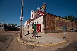
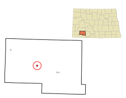
Mott is a city in and the county seat of Hettinger County, North Dakota, United States. The population was 653 at the 2020 census.
New England is a city in Hettinger County, North Dakota, United States. The population was 683 at the 2020 census.
Hankinson is a city in Richland County, North Dakota, United States. The population was 921 at the 2020 census. Hankinson was founded in 1886. It is part of the Wahpeton, ND–MN Micropolitan Statistical Area.
Hoople is a city in Walsh County, North Dakota, United States. The population was 247 at the 2020 census. Hoople, named for early settler Alan Hoople, was founded in 1889. Hoople's nickname is "Tatertown."
Mound City is a town in and the county seat of Campbell County, South Dakota, United States. The population was 69 at the 2020 census.
Wagner is a city in Charles Mix County, South Dakota, United States. The population was 1,490 at the 2020 census. The city is served by Wagner Municipal Airport as well as YST Transit buses.
Clear Lake is a city in and the county seat of Deuel County, South Dakota, United States. The population was 1,218 at the 2020 census.
Milbank is a city in Grant County, South Dakota, United States, located along the South Fork of the Whetstone River. The population was 3,544 at the 2020 census. It is the county seat of Grant County. Milbank is the birthplace of American Legion Baseball. The program was created in Milbank in 1925 and is now enjoyed by high school aged youth on more than five thousand teams in all fifty states.
Parkston is a city in Hutchinson County, South Dakota, United States. The population was 1,567 at the 2020 census.
Whitewood is a city in Lawrence County, South Dakota, United States. The population was 879 at the 2020 census.
Presho is a small city in Lyman County, South Dakota, United States. The population was 472 at the 2020 census.
Leola is a small city in, and the county seat of, McPherson County, South Dakota, United States. It was founded on May 1, 1884, and named for Leola Haynes, daughter of one of the town's founders. The population was 434 as of the 2020 census.
Crooks is a city in Minnehaha County, South Dakota, United States and is a suburb of Sioux Falls. The population was 1,362 at the 2020 census. Crooks was named New Hope until 1904. The town's present name honors W. A. Crooks, a local politician.
Garretson is a city in Minnehaha County, South Dakota, United States. The city had a population of 1,228 at the 2020 census.
Hartford is a suburban American city in Minnehaha County, South Dakota, a few miles northwest of Sioux Falls. Its population was 3,354 at the 2020 census.