Relascope

Last updated
a Relascope (Spiegelrelaskop) Spiegelrelaskop nach Walter Bitterlich.JPG
a Relascope (Spiegelrelaskop)

The relascope, invented by Walter Bitterlich, is a multi-use instrument for forest inventory. It is primarily used to find the height of a tree, the basal area of a tree, and the diameter of a tree anywhere along the bole. This instrument is used mostly for applications involving variable radius sample plots in a forest survey.

Contents

Method of operation

The relascope has a sight hole on the back and a clear window at the front to allow the user to sight through the tool. There are three light inlet holes which are used to light the scale. This is one of the major problems with the relascope, the way this instrument is designed it cannot be used in low light. [1] This is not a problem with the electronic laser based version, called a tele-relascope.

Use

Relascope usage 20181206-FS-APACHE-SITGREAVES-LSC-0935.jpg
Relascope usage

The Relascope is used by looking through the hole in the front of the instrument. When users look through this hole they will see several scales that are used for different measurements on the bottom half of their view, and on the top half they will see the tree that they are looking at. There are three scales for height of the tree used depending on the distance of the user from the tree, five scales for diameter and two scales for basal area used depending on desired basal area factor. [1]

Function

The Relascope is very similar to the angle gauge and the wedge prism in that it can be used to find the basal area of a tree from a point depending on the basal area factor in a variable radius sampling method. The main difference in this instrument though is that it has multiple uses as described previously. Some other advantages over similar devises in that it accounts for the slope one is from the tree giving a more accurate measurement than similar tools. [2]

The Relascope can also be used to find the distance from a tree (range). This is done in the same manner as when one uses a transit using a set of trigonometric formulae based on height and angle. The Relascope is not commonly used for this because of its difficulty and the amount of time it takes to do this. [1]

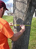
Tree height is another use of this instrument. It does this by using several weighted wheels that spin based on the position of the instrument. The readings off of this scale will give the height of the tree based on the user's distance from the tree. When taking height, users measure either 66 or 120 feet from the tree; this is the reason for the multiple scales in the relascope. Users then look first at the top of the tree or at the highest point on the bole that they want to measure and record the number from the height dial inside the scope, then they look at the bottom of the tree to find a positive or negative number. They take this number and subtract it from the first number recorded; this gives the height of the tree. This is very similar to the way a clinometer is used. [1]

Point sampling

Figure 1 Relascope 3.png
Figure 1

The Relascope is often used for point sampling. This is done by using the set spacing marked in the Relascope to gauge whether a tree is in or out of the stand. A tree is IN or OUT based on whether it fills the space between the lines on the scale in the Relascope. If it does then the tree is IN. If it doesn't then the tree is OUT (Figure 1). If the tree is IN this means that it is counted as basal area within one's plot. The basal area is obtained by multiplying the number of trees by the basal area factor, which is based on the width of the gauge. [2]

Related Research Articles

Pressure measurement Analysis of force applied by a fluid on a surface

Pressure measurement is the analysis of an applied force by a fluid on a surface. Pressure is typically measured in units of force per unit of surface area. Many techniques have been developed for the measurement of pressure and vacuum. Instruments used to measure and display pressure in an integral unit are called pressure meters or pressure gauges or vacuum gauges. A manometer is a good example, as it uses the surface area and weight of a column of liquid to both measure and indicate pressure. Likewise the widely used Bourdon gauge is a mechanical device, which both measures and indicates and is probably the best known type of gauge.

Inclinometer

An inclinometer or clinometer is an instrument used for measuring angles of slope, elevation, or depression of an object with respect to gravity's direction. It is also known as a tilt indicator, tilt sensor, tilt meter, slope alert, slope gauge, gradient meter, gradiometer, level gauge, level meter, declinometer, and pitch & roll indicator. Clinometers measure both inclines and declines using three different units of measure: degrees, percent, and topo. Astrolabes are inclinometers that were used for navigation and locating astronomical objects from ancient times to the Renaissance.

Indicator (distance amplifying instrument) Distance amplifying instrument

In various contexts of science, technology, and manufacturing, an indicator is any of various instruments used to accurately measure small distances and angles, and amplify them to make them more obvious. The name comes from the concept of indicating to the user that which their naked eye cannot discern; such as the presence, or exact quantity, of some small distance.

Surface metrology is the measurement of small-scale features on surfaces, and is a branch of metrology. Surface primary form, surface fractality and surface roughness are the parameters most commonly associated with the field. It is important to many disciplines and is mostly known for the machining of precision parts and assemblies which contain mating surfaces or which must operate with high internal pressures.

Stadiametric rangefinding

Stadiametric rangefinding, or the stadia method, is a technique of measuring distances with a telescopic instrument. The term stadia comes from a Greek unit of length Stadion which was the typical length of a sports stadium of the time. Stadiametric rangefinding is used for surveying and in the telescopic sights of firearms, artillery pieces, or tank guns, as well as some binoculars and other optics. It is still widely used in long-range military sniping, but in many professional applications it is being replaced with microwave, infrared, or laser rangefinding methods. Although much easier to use, electronic rangefinders can give away the shooter's position to a well-equipped adversary, and the need for accurate range estimation existed for much longer than electronic rangefinders small and rugged enough to be suitable for military use.

The following outline is provided as an overview of and guide to forestry:

Basal area is the cross-sectional area of trees at breast height. It is a common way to describe stand density. In forest management, basal area usually refers to merchantable timber and is given on a per hectare or per acre basis. If you cut down all the merchantable trees on an acre at 4 ½ feet off the ground and measured the square inches on the top of each stump (πr*r), added them all together and divided by square feet, that would be the basal area on that acre. In forest ecology, basal area is used as a relatively easily-measured surrogate of total forest biomass and structural complexity, and change in basal area over time is an important indicator of forest recovery during succession .

Meteorological instrumentation

Meteorological instruments or weather instruments are the equipment used to find the state of the atmosphere at a given time. Each science has its own unique sets of laboratory equipment. Meteorology, however, is a science which does not use much laboratory equipment but relies more on on-site observation and remote sensing equipment. In science, an observation, or observable, is an abstract idea that can be measured and for which data can be taken. Rain was one of the first quantities to be measured historically. Two other accurately measured weather-related variables are wind and humidity. Many attempts had been made prior to the 15th century to construct adequate equipment to measure atmospheric variables.

Diameter tape

A diameter tape (D-tape) is a measuring tape used to estimate the diameter of a cylinder object, typically the stem of a tree or pipe. A diameter tape has either metric or imperial measurements reduced by the value of π. This means the tape measures the diameter of the object. It is assumed that the cylinder object is a perfect circle. The diameter tape provides an approximation of diameter; most commonly used in dendrometry.

Forest inventory is the systematic collection of data and forest information for assessment or analysis. An estimate of the value and possible uses of timber is an important part of the broader information required to sustain ecosystems. When taking forest inventory the following are important things to measure and note: species, diameter at breast height (DBH), height, site quality, age, and defects. From the data collected one can calculate the number of trees per acre, the basal area, the volume of trees in an area, and the value of the timber. Inventories can be done for other reasons than just calculating the value. A forest can be cruised to visually assess timber and determine potential fire hazards and the risk of fire. The results of this type of inventory can be used in preventive actions and also awareness. Wildlife surveys can be undertaken in conjunction with timber inventory to determine the number and type of wildlife within a forest. The aim of the statistical forest inventory is to provide comprehensive information about the state and dynamics of forests for strategic and management planning. Merely looking at the forest for assessment is called taxation.

Borderline tree is a term used in forestry.

Angle gauge

An angle gauge is a tool used by foresters to determine which trees to measure when using a variable radius plot design in forest inventory. Using this tool a forester can quickly measure the trees that are in or out of the plot. An angle gauge is similar to a wedge prism though it must be held a fixed distance from the eye to work properly. Unlike the wedge prism, which is held over the plot center, the surveyor's eye is kept over plot-center when using an angle gauge.

Wedge prism

The wedge prism is a prism with a shallow angle between its input and output surfaces. This angle is usually 3 degrees or less. Refraction at the surfaces causes the prism to deflect light by a fixed angle. When viewing a scene through such a prism, objects will appear to be offset by an amount that varies with their distance from the prism.

The Biltmore stick is a tool used by foresters to estimate tree trunk diameter at breast height. The tool very often includes a hypsometer scale to estimate height as well. It looks much like an everyday yardstick. With practice a Biltmore stick is considered to be exceptionally accurate, more often within 13 millimetres on diameters. Some foresters use the tool regularly, however, many prefer to use more accurate tools such as a diameter tape to measure diameter at breast height (DBH) and a clinometer to measure height. On the other end of the spectrum, some foresters consider the use of a Biltmore stick to be no more accurate than their own visual estimates, and make it practice for their surveys to be largely completed in this manner.

Sine quadrant Type of quadrant used by medieval Arabic astronomers

The sine quadrant was a type of quadrant used by medieval Arabic astronomers. It is also known as a "sinecal quadrant" in the English-speaking world. The instrument could be used to measure celestial angles, to tell time, to find directions, or to determine the apparent positions of any celestial object for any time. The name is derived from the Arabic "rub‘‘‘" meaning a quarter and "mujayyab" meaning marked with sine. It was described, according to King, by Muhammad ibn Mūsā al-Khwārizmī in 9th century Baghdad.

In the field of industrial ultrasonic testing, ultrasonic thickness measurement (UTM) is a method of performing non-destructive measurement (gauging) of the local thickness of a solid element based on the time taken by the ultrasound wave to return to the surface. This type of measurement is typically performed with an ultrasonic thickness gauge.

Tree height is the vertical distance between the base of the tree and the tip of the highest branch on the tree, and is difficult to measure accurately. It is not the same as the length of the trunk. If a tree is leaning, the trunk length may be greater than the height of the tree. The base of the tree is where the projection of the pith (center) of the tree intersects the existing supporting surface upon which the tree is growing or where the seed sprouted. If the tree is growing on the side of a cliff, the base of the tree is at the point where the pith would intersect the cliff side. Roots extending down from that point would not add to the height of the tree. On a slope this base point is considered as halfway between the ground level at the upper and lower sides of the tree. Tree height can be measured in a number of ways with varying degrees of accuracy.

A part of tree measurement is measurement of the crown of a tree, which consists of the mass of foliage and branches growing outward from the trunk of the tree. The average crown spread is the average horizontal width of the crown, taken from dripline to dripline as one moves around the crown. The dripline being the outer boundary to the area located directly under the outer circumference of the tree branches. When the tree canopy gets wet, any excess water is shed to the ground along this dripline. Some listings will also list the maximum crown spread which represents the greatest width from dripline to dripline across the crown. Other crown measurements that are commonly taken include limb length, crown volume, and foliage density. Canopy mapping surveys the position and size of all of the limbs down to a certain size in the crown of the tree and is commonly used when measuring the overall wood volume of a tree.

Tree volume is one of many parameters that are measured to document the size of individual trees. Tree volume measurements serve a variety of purposes, some economic, some scientific, and some for sporting competitions. Measurements may include just the volume of the trunk, or the volume of the trunk and the branches depending on the detail needed and the sophistication of the measurement methodology.

Trees have a wide variety of sizes and shapes and growth habits. Specimens may grow as individual trunks, multitrunk masses, coppices, clonal colonies, or even more exotic tree complexes. Most champion tree programs focus finding and measuring the largest single-trunk example of each species. There are three basic parameters commonly measured to characterize the size of a single trunk tree: height, girth, and crown spread. Additional details on the methodology of Tree height measurement, Tree girth measurement, Tree crown measurement, and Tree volume measurement are presented in the links herein. A detailed guideline to these basic measurements is provided in The Tree Measuring Guidelines of the Eastern Native Tree Society by Will Blozan.

References

  1. 1 2 3 4 Brack, Cris (1996-02-09). "Spiegel Relaskop". Forest Measurements and Modeling. Australian National University. Retrieved 2010-06-01.
  2. 1 2 Avery, Thomas Eugene; Harold Burkhart (2001-06-07). Forest Measurements, 7th ed. McGraw-Hill Science/Engineering/Math. pp. 236–237. ISBN   978-0-07-366176-6.