
Norfolk is a New England town in Norfolk County, Massachusetts, United States, with a population of 11,662 people at the 2020 census. Formerly known as North Wrentham, Norfolk broke away to become an independent town in 1870.

Newtonville is one of the thirteen villages within the city of Newton in Middlesex County, Massachusetts, United States.
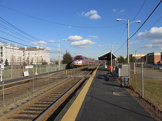
Dedham Corporate Center station is an MBTA Commuter Rail station in Dedham, Massachusetts. It serves the Franklin/Foxboro Line, and is located just off exit 28 of Interstate 95/Route 128. It serves mostly as a park-and-ride location. The station consists of two platforms serving the Franklin/Foxboro Line's two tracks. Previous stations named Dedham Junction and Rust Craft (1955-1977) were located near the modern site.

Attleboro station is a commuter rail station on the MBTA's Providence/Stoughton Line located in Attleboro, Massachusetts. By a 2018 count, Attleboro had 1,547 daily riders, making it the fourth busiest station on the system outside Boston.

Stoughton station is an MBTA Commuter Rail station in downtown Stoughton, Massachusetts. It is the current terminus of the Stoughton Branch of the Providence/Stoughton Line. The station has a parking lot to serve local riders and those driving from further south, as Stoughton is close to the Massachusetts Route 24 expressway. Stoughton currently has one platform serving one track; the platform has a mini-high section for accessibility.
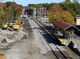
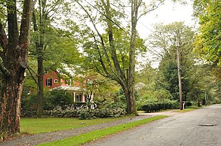
Norfolk station is an MBTA Commuter Rail station in Norfolk, Massachusetts, served by the Franklin/Foxboro Line. The station has one platform which serves a single track, with a mini-high section for accessibility. The Norfolk County Railroad opened through the North Wrentham village of Wrentham in 1849. A branch line to Medway was open from 1852 to 1864. The station was renamed Norfolk along with the town in 1870. Several different railroads operated the line, with the New York, New Haven and Hartford Railroad running it for much of the 20th century. Massachusetts Bay Transportation Authority (MBTA) subsidies began in 1966, and the agency bought the line in 1973. The mini-high platform was added in 1990.

Kendal Green station is an MBTA Commuter Rail station in Weston, Massachusetts, US, served by the Fitchburg Line. The station has a single platform serving two tracks; it is not accessible. It originally opened with the Fitchburg Railroad in 1844 as "Weston"; it was renamed Kendal Green after the green cloth around 1886. A new station building was constructed in 1896. Service passed to the Boston and Maine Railroad in 1900, and to the Massachusetts Bay Transportation Authority (MBTA) in the 1970s. The former station building, reused as a private residence, was added to the National Register of Historic Places in 2000 as a contributing property to the Kendal Green Historic District.

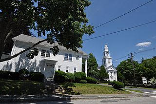
The Newtonville Historic District is a historic district in the village of Newtonville, in Newton, Massachusetts. The district encompasses the southern portion of the village's business district, as well as surrounding residential areas. It was listed on the National Register of Historic Places in 1986, and enlarged in 1990.

The Norfolk Grange Hall, previously known as First Baptist Church, is a historic Grange hall and former Baptist church at 28 Rockwood Road in Norfolk, Massachusetts. Built in 1863, it is one of the town's few surviving 19th-century civic buildings. Since 1921 it has been owned by the Norfolk Grange # 135 and used as its meeting hall. It was listed on the National Register of Historic Places in 1989.

The West Brookfield Center Historic District is a historic district encompassing the historic center of West Brookfield, Massachusetts. When first listed on the National Register of Historic Places in 1990, it was centered on the triangular junction of Main Street, North Main Street, and School Street, extending away from this area along Main Street, North Main Street, and Foster Hill Road. A few of its properties lie on side streets adjacent to these roads. This area represented the core of Brookfield, before it was broken into smaller communities, including West Brookfield. It has a fine collection of 18th and 19th century homes, ranging stylistically from Federal to Queen Anne, as well as the town hall and public library.

The Millis Center Historic District is an historic district on Curve, Daniels, Exchange, Irving, Lavender, Main, and Union Streets in Millis, Massachusetts. It encompasses the historic mid-to-late-19th century village center of the town, including the residential area north of Main Street, two 19th-century industrial complexes, and civic and institutional buildings. It was added to the National Register of Historic Places in 2007.
Church Street Historic District is a historic district roughly on Church Street between Park Ave. and Highland St. in Ware, Massachusetts. This mainly residential area includes some of Ware's finest late 19th century houses and a well-preserved collection of Greek Revival houses. The area was developed primarily in response to the growth of industry to the south. The district was listed on the National Register of Historic Places in 1983.
The Ware Center Historic District encompasses the historic early center of Ware, Massachusetts. Centered at the junction of Massachusetts Route 9 with Greenwich Plains Road, it is a linear district extending about 0.5 miles (0.80 km) along Route 9 in either direction. Most of the structures in the district were built between 1760 and 1860, although there are some 20th century intrusions. The area was the center of town civic and commercial activity until the 1820s, when villages serving industry became more important. The district was listed on the National Register of Historic Places in 1986.

The Russell Center Historic District is a historic district encompassing the historic village center of Russell, Massachusetts. It is centered at the junction of Main Street and Lincoln Avenue, and is bordered by the Westfield River to the east, and the rising foothills of The Berkshires to the west. The village's 19th century development was spurred by the railroad and sustained by local papermaking businesses. It was listed on the National Register of Historic Places in 1996, and was named as one of the 1,000 places to visit in Massachusetts by the Great Places in Massachusetts Commission.
The Silver Hill Historic District encompasses the first major residential subdivision of Weston, Massachusetts. It includes 79 buildings on Silver Hill and Westland Roads, and Merriam Street. The area of Silver Hill and Westland Roads was formally laid out in 1905, while Merriam Street is a very old country road which had seen some development in the 1890s. The houses in the district are predominantly Colonial Revival and Queen Anne in their styling, a relative rarity in Weston although common in other Boston suburbs. The district was added to the National Register of Historic Places in 2004.

The Kendal Green Historic District is a rural residential district running along North Avenue in Weston, Massachusetts. It extends for about three-quarters of a mile, and includes elements representative of the development of Weston from a rural agricultural community to a residential suburb of Boston. In addition to a variety of predominantly residential and agricultural properties, it includes two formerly industrial sites important in Weston's history: the site of the Hobbs Tannery, and that of the Hook and Hastings Organ Factory. The district was listed on the National Register of Historic Places in 2000.
The Putnam Street Historic District is a residential historic district roughly bounded by Winthrop, Putnam, Temple, and Shaw Streets in Newton, Massachusetts. It encompasses a residential area located on the hill just south of West Newton which was developed between the 1860s and 1880s. The 20 properties in the nearly 8-acre (3.2 ha) district are primarily Second Empire, Queen Anne, and Stick style. The district was listed on the National Register of Historic Places in 1986.

Fort Hill is a 0.4 square mile neighborhood and historic district of Roxbury, in Boston, Massachusetts. The approximate boundaries of Fort Hill are Malcolm X Boulevard on the north, Washington Street on the southeast, and Columbus Avenue on the southwest.

The history of rail in Dedham, Massachusetts begins with the introduction of the first rail line in 1836 and runs to the present day. Multiple railroads have serviced Dedham since then, and current service is provided by the MBTA. The station in Dedham Square built in 1881 out of Dedham Granite was demolished in 1951 and the stones were used to put an addition on the Town's library. There are two active stations today, and multiple others in close proximity.

The Medway Branch was a railway line in Norfolk County, Massachusetts. It was built by the Medway Branch Railroad in 1852. It ran from North Wrentham, Massachusetts, where it connected with the main line of the Norfolk County Railroad, to Medway, Massachusetts. The 3.6-mile (5.8 km) Medway Branch was abandoned in 1864, following the 1861 completion of the New York and Boston Railroad's separate line through Medway.


