St. Lazare is an unincorporated community recognised as a local urban district in the Rural Municipality of Ellice – Archie within the Canadian province of Manitoba that held village status prior to January 1, 2015.
Plum Coulee is an unincorporated urban community in the Municipality of Rhineland within the Canadian province of Manitoba that held town status prior to January 1, 2015. It is west of Altona, one hour southwest of Winnipeg and 22 kilometres from the United States border. It is also the former home to the Plum Coulee Xpress hockey club. It has an artificial beach located in town called Sunset Beach.
Grandview is an unincorporated urban community in the Grandview Municipality within the Canadian province of Manitoba that held town status prior to January 1, 2015. It is located 45 kilometres west of the City of Dauphin along the Valley River.
St. Claude is an unincorporated community recognized as a local urban district in the Rural Municipality of Grey within the Canadian province of Manitoba that held village status prior to January 1, 2015.

Gretna is an unincorporated urban community in the Municipality of Rhineland within the Canadian province of Manitoba that held town status prior to January 1, 2015. Just north of the Canada - United States border on PTH 30, Gretna had a population of 541 in 2016.

Baldur is an unincorporated community recognized as a local urban district in the Canadian province of Manitoba, located in the Rural Municipality of Argyle. Baldur is the largest community of the municipality, which is in southwestern Manitoba between Brandon and Portage la Prairie. The community is named after the Norse god Baldur.

Crystal City is an unincorporated community recognized as a local urban district in the Municipality of Louise within the Canadian province of Manitoba. It held village status prior to January 1, 2015. It is located on Highway 3, 16 kilometres north of the Canada–United States border and 200 kilometres southwest of Winnipeg.
Ethelbert is an unincorporated urban community in the Municipality of Ethelbert, Manitoba, Canada.

Gladstone is an unincorporated urban community in the Municipality of WestLake – Gladstone within the Canadian province of Manitoba that held town status prior to January 1, 2015. It is located on the Yellowhead Highway at the intersection with Highway 34. The Gladstone railway station receives Via Rail service.
Notre Dame de Lourdes is an unincorporated community recognized as a local urban district in the Municipality of Lorne within the Canadian province of Manitoba that held village status prior to January 1, 2015. It is located within the Central Plains Region, 100 km southwest of Winnipeg. The community had a population of 683 inhabitants in the 2011 census, an increase of 16.0% from the 589 inhabitants during the 2006 census.
Oakville, Manitoba is an unincorporated community recognized as a local urban district in Manitoba. It is located in the Rural Municipality of Portage la Prairie. Oakville is 56 km (35 mi) west of Winnipeg off highway 13.
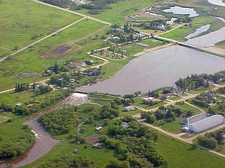
Rapid City is an unincorporated community recognized as a local urban district that also once held town status in southwest Manitoba, Canada within the Rural Municipality of Oakview. It is located about 30 km north of Brandon. Rapid City is a farming community that is developed on the banks of the Little Saskatchewan River. The dam and reservoir in Rapid City were built by the province in 1961, the reservoir stores 200 acre-feet (250,000 m3) and provides a water supply and recreational facility for the community.

Somerset is an unincorporated community recognized as a local urban district in the Municipality of Lorne within the Canadian province of Manitoba that held village status prior to January 1, 2015.
La Rivière is an unincorporated community recognized as a local urban district in Manitoba, Canada. It is located 11 km west of the town of Manitou on Highway 3. It is located in the Municipality of Pembina. La Riviere was founded 1886 by Metis Franco-Manitobans, however it is predominantly English speaking. It has a post office, credit union, a five-lift ski hill, a construction company, and a seasonal drive-in restaurant. It has a full service campground at the edge of the community that backs onto the Pembina River. La Riviere was previously home to Hamm-tone Guitars and Mandolins and the Pembina Valley Guitar Building Course.
Garson is a designated place within the Rural Municipality of Brokenhead in the Canadian province of Manitoba. Originally named Lyall, it held village status from 1915 to 2003. It now forms part of the Local Urban District of Tyndall-Garson.

Bellis is a hamlet in central Alberta, Canada within Smoky Lake County. Previously an incorporated municipality, Bellis dissolved from village status on January 1, 1946 to become part of the Municipal District of Vilna No. 575.
Laurier is an unincorporated urban community in the Rural Municipality of Ste. Rose, Manitoba, Canada. It is located on Highway 480, 3.2 km (2.0 mi) west of Highway 5, between the community of McCreary to the south and the community of Ste. Rose du Lac to the north.
Swan Lake is a local urban district within the Municipality of Lorne in the Canadian province of Manitoba. It is recognized as a designated place by Statistics Canada.
