
The Old Centre Historic District is a historic district encompassing the historic town center of Winchendon, Massachusetts. It includes the town's first cemetery, the First Congregational Church, and the oldest surviving house in town, and only one building constructed after 1850. The district was added to the National Register of Historic Places in 1987.

The Center Village District encompasses the historic village center of Lancaster, Massachusetts. Settled in 1643, it has few traces of its early history, but is now a well-kept rural town center with a predominantly residential and civic character. It includes the First Church of Christ, Lancaster, which is a U.S. National Historic Landmark, and was listed on the National Register of Historic Places in 1977.

Hubbardston Town Common Historic District encompasses the town common of Hubbardston, Massachusetts, the adjacent 1773 First Parish Church, and the town's first burying ground. It has been the center of the town's civic and religious life since its incorporation in the 1760s, and was listed on the National Register of Historic Places in 2000. The district was named as one of the 1,000 Places to Visit in Massachusetts by the Great Places in Massachusetts Commission.

The Harvard Center Historic District is a historic district encompassing the traditional village center of Harvard, Massachusetts, USA. The district is centered on the town common, a triangular grassy space bounded by Elm Street, Still River Road, and Ayer Road. The common is ringed by residences, civic and religious buildings, and a small commercial area. The common was laid out when the town was founded in 1732, and has grown, mainly in periods of growth at the late 18th and late 19th/early 20th centuries. Most of the village's buildings post-date 1831. The district was added to the National Register of Historic Places in 1997.
The Templeton Common Historic District encompasses the historic town center of Templeton, Massachusetts. Laid out in the 1750s, the area has been the focus of the town's civic and economic affairs since, and includes its finest assortment of 18th and early 19th-century architecture. The district was added to the National Register of Historic Places in 1983. The district was in 2010 named as one of the 1,000 places to visit in Massachusetts by the Great Places in Massachusetts Commission.

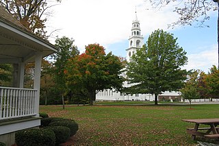
The Petersham Common Historic District encompasses the historic town center of Petersham, Massachusetts. Laid out in 1733 and centered on the town common bounded by Main and Common Streets, it retains most of its 19th-century character, with only a few turn-of-the-20th-century civic buildings adding later character. The district was added to the National Register of Historic Places in 1982.

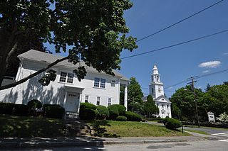
The Shrewsbury Historic District encompasses the historic early center of the town of Shrewsbury, Massachusetts. It consists of the town common, laid out in 1721 at what are now Main and Prospect Streets, and buildings adjacent or nearby. The district was declared locally in 1972, and was added to the National Register of Historic Places in 1976.

The Cohasset Common Historic District is a historic district encompassing the historic town center of Cohasset, Massachusetts. It is centered on the town common, which is bounded by Highland Ave., N. Main St., William B. Long, Jr., Rd. and Robert E. Jason Road. The district was added in 1996 to the National Register of Historic Places.

The Montague Center Historic District encompasses the well-preserved 19th century village center of Montague, Massachusetts. Montague Center, one of the town's five villages, is the civic heart of the town, and was also an active industrial area in the 19th century. The district was listed on the National Register of Historic Places in 2001.

The New Salem Common Historic District encompasses the historic town center of New Salem, Massachusetts. Located on South Main Street, it includes the town common and most of its civic and institutional buildings. Most buildings in the district date to the 18th and 19th centuries. The district was listed on the National Register of Historic Places in 1978.
Church Street Historic District is a historic district roughly on Church Street between Park Ave. and Highland St. in Ware, Massachusetts. This mainly residential area includes some of Ware's finest late 19th century houses and a well-preserved collection of Greek Revival houses. The area was developed primarily in response to the growth of industry to the south. The district was listed on the National Register of Historic Places in 1983.
The South Amherst Common Historic District encompasses the village common and surrounding buildings of South Amherst, Massachusetts. This area developed as a rural residential village hub in the 18th and 19th centuries. It was listed on the National Register of Historic Places in 1995.

The Russell Center Historic District is a historic district encompassing the historic village center of Russell, Massachusetts. It is centered at the junction of Main Street and Lincoln Avenue, and is bordered by the Westfield River to the east, and the rising foothills of The Berkshires to the west. The village's 19th century development was spurred by the railroad and sustained by local papermaking businesses. It was listed on the National Register of Historic Places in 1996, and was named as one of the 1,000 places to visit in Massachusetts by the Great Places in Massachusetts Commission.

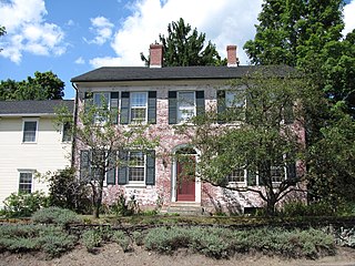
The Ludlow Center Historic District encompasses the historic village center of Ludlow, Massachusetts. Centered on the junction of Center, Church and Booth Streets, it is the site selected as the town center when Ludlow was established in 1774. Its notable structures include the Congregational Church, the old town hall, and a number of farmhouses that date to the first half of the 19th century. The area has remained a center of civic life in the town, even though its economic center moved later in the 19th century to Ludlow Village. The district was listed on the National Register of Historic Places in 1988.

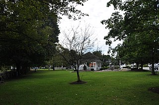
The Longmeadow Historic District is a historic district encompassing the village green of Longmeadow, Massachusetts and properties in its immediate vicinity. The district acquired local protection in 1973 and was added to the National Register of Historic Places in 1982.

The John Eliot Historic District encompasses what was the historic early village center of Natick, Massachusetts. Now the heart of the village of South Natick, it now exhibits a diversity of architecture from the 18th to early 20th centuries, laid out along historic 17th-century colonial routes. It was listed on the National Register of Historic Places in 1983.

The Lower Main Street Historic District of Lee, Massachusetts encompasses the historic center of the town. It is centered on the junction of Main and Park Streets, where the center of the town was laid out when it was established in 1760. Although a meeting house was erected on this site, that structure was torn down, and the space was converted into a town common, a function it continues to serve today. The district also includes a portion of the business district, running along Main Street. The district was listed on the National Register of Historic Places in 1976.

The Jewell Town District of South Hampton, New Hampshire, encompasses a colonial-era industrial village with a history dating to 1687. It is centered at the junction of West Whitehall and Jewell Streets, which is just south of a bend in the Powwow River, the source of the power for the mills that were built here. The area was settled in 1687 by Thomas Jewell, and by the early 19th century included a variety of mills as well as a bog iron works. The district now includes only remnants of its industrial past, and features a collection of 18th and early-19th century residential architecture. The district was listed on the National Register of Historic Places in 1983.
The Salem Common Historic District encompasses the early colonial center of Salem, New Hampshire. The district dates to the earliest period of settlement of Salem, and includes the historic common, old town hall, fire station, and library. The town hall was built in 1738 and extensively altered in 1838 and 1899; it served as a place for town meetings until 1958. The district was listed on the National Register of Historic Places in 2011.
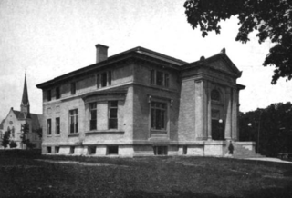
The Winchendon Village Historic District encompasses the 19th-century commercial center of Winchendon, Massachusetts. It extends along Front and School Streets from School Square to Spring Street, and continues north on Central Street as far as Summer Street. This area was developed primarily because of industrialization that took place along Miller's River beginning in the late 18th century and extending into the 1830s, and then expanded further with the arrival of the railroad in the area in the 1840s. This growth caused the area to eclipse the town's colonial town center. The area had risen to sufficient prominence by 1850 that the town hall was built there, which would be followed by other municipal buildings, including the 1913 Beals Memorial Library. The district was listed on the National Register of Historic Places in 1993.


