
Bodmin Moor is a granite moorland in north-eastern Cornwall, England, United Kingdom. It is 208 square kilometres (80 sq mi) in size, and dates from the Carboniferous period of geological history. It includes Brown Willy, the highest point in Cornwall, and Rough Tor, a slightly lower peak. Many of Cornwall's rivers have their sources here. It has been inhabited since at least the Neolithic era, when early farmers started clearing trees and farming the land. They left their megalithic monuments, hut circles and cairns, and the Bronze Age culture that followed left further cairns, and more stone circles and stone rows. By medieval and modern times, nearly all the forest was gone and livestock rearing predominated.

Cornwall is a ceremonial county in South West England. It is recognised by Cornish and Celtic political groups as one of the Celtic nations, and is the homeland of the Cornish people. The county is bordered by the Atlantic Ocean to the north and west, Devon to the east, and the English Channel to the south. The largest urban area in the county is a conurbation that includes the former mining towns of Redruth and Camborne, and the county town is the city of Truro.

Lamorna is a village, valley and cove in west Cornwall, England, UK. It is on the Penwith peninsula approximately 4 miles (6 km) south of Penzance. Lamorna became popular with the artists of the Newlyn School, including Alfred Munnings, Laura Knight and Harold Knight, and is also known for former residents Derek and Jean Tangye who farmed land and wrote "The Minack Chronicles".

Cornwall is a town in Litchfield County, Connecticut, United States. The population was 1,567 at the 2020 census. The town is part of the Northwest Hills Planning Region.

Cornwall-on-Hudson is a riverfront village in the town of Cornwall, Orange County, New York, United States. It lies on the west bank of the Hudson River, approximately 50 miles (80 km) north of New York City. The population as of the 2020 census was 3,075. It is part of the Poughkeepsie–Newburgh–Middletown metropolitan area as well as the larger New York metropolitan area.
A bardic name is a pseudonym used in Wales, Cornwall, or Brittany by poets and other artists, especially those involved in the eisteddfod movement.

St Neot is a village and civil parish in Cornwall, England, United Kingdom. The parish population at the 2011 census was 947. It is between the towns of Bodmin and Liskeard.

Saint Austell is a town in Cornwall, England, United Kingdom, 10 miles (16 km) south of Bodmin and 30 miles (48 km) west of the border with Devon.

Greenway, also known as Greenway House, is an estate on the River Dart near Galmpton in Devon, England. Once the home of the author Agatha Christie, it is now owned by the National Trust.
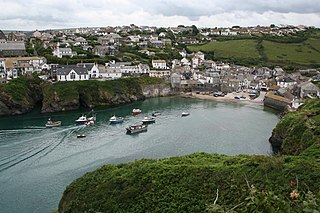
Port Isaac is a small fishing village on the Atlantic coast of north Cornwall, England, in the United Kingdom. The nearest towns are Wadebridge and Camelford, each ten miles (16 km) away. A nearby hamlet, Port Gaverne, is sometimes considered to be part of Port Isaac. The meaning of the village's Cornish name, Porthysek, is "corn port", indicating a trade in corn from the arable inland district.

St Mawes is a village on the end of the Roseland Peninsula, in the eastern side of Falmouth harbour, on the south coast of Cornwall, England. The village, formerly two separate hamlets, lies on the east bank of the Carrick Roads, a large waterway created after the Ice Age from an ancient valley which flooded as the melt waters caused the sea level to rise. The immense natural harbour thus created is claimed to be the third largest in the world. St Mawes was once a busy fishing port, but the trade declined during the 20th century and the village now serves as a popular tourist location, with many properties functioning as holiday accommodation. The village is in the civil parish of St Just in Roseland and lies within the Cornwall Area of Outstanding Natural Beauty (AONB).

The Roseland Peninsula, or just Roseland, is a district of west Cornwall, England. Roseland is located in the south of the county and contains the town of St Mawes and villages such as St Just and Gerrans. It is a peninsula, separated from the remainder of Cornwall by the River Fal.

Menheniot railway station serves the village of Menheniot in Cornwall, England. It is 261 miles 61 chains (421.3 km) from London Paddington via Box and Plymouth Millbay.

Castle an Dinas is an Iron Age hillfort at the summit of Castle Downs near St Columb Major in Cornwall, UK and is considered one of the most important hillforts in the southwest of Britain. It dates from around the 3rd to 2nd century BCE and consists of three ditch and rampart concentric rings, 850 feet (260 m) above sea level. During the early 1960s it was excavated by a team led by Dr Bernard Wailes of the University of Pennsylvania during two seasons of excavation.

Germoe is a village and civil parish in Cornwall, England, United Kingdom. Germoe village, the parish's main settlement and church town, is about five miles (8 km) west of Helston and seven miles (11.3 km) east of Penzance. The A394 Penzance to Helston road runs along the southern border of the parish. Other settlements in the parish include Balwest, Boscreege and Tresowes Green.
William John Burley was a Cornish crime writer, best known for his books featuring the detective Charles Wycliffe, which became the basis of the popular television series Wycliffe, shown from 1994 to 1998.

Moodna Creek is a small tributary of the Hudson River that drains eastern Orange County, New York. At 15.5 miles (25 km) in length from its source at the confluence of Cromline Creek and Otter Kill west of Washingtonville, it is the longest stream located entirely within the county.

Blackwater is a village in Cornwall, England, United Kingdom. It is situated in the parish of St Agnes between Truro and Redruth. The village lies on the old course of the A30 north of the current course which bypasses it. The village has a primary school which serves the village and surrounding settlements.

Porthoustock is a hamlet near St Keverne in Cornwall, England, United Kingdom, on the east coast of Lizard Peninsula. Aggregates are quarried nearby and Porthoustock beach is dominated by a large concrete stone silo that was once used to store stone ready to load ships but is now disused. Coastal trading ships of up to 82 metres can dock alongside the pier along the southern edge of the beach to be loaded with stone. Fishing boats operate from the pebble beach, with lobster and crab potting, net fishing and hand lines as the principal fishing methods. The South West Coast Path passes through Porthoustock.

St Cleer is a civil parish and village in east Cornwall, England, United Kingdom. The village is situated on the southeast flank of Bodmin Moor approximately two miles (3 km) north of Liskeard. The population of the parish in 2001 numbered 3257. This includes Common Moor and had increased to 3,297 at the 2011 census. An electoral ward also exists. The population at the 2011 census is 4,366.

