Hydrology is the scientific study of the movement, distribution, and management of water on Earth and other planets, including the water cycle, water resources, and drainage basin sustainability. A practitioner of hydrology is called a hydrologist. Hydrologists are scientists studying earth or environmental science, civil or environmental engineering, and physical geography. Using various analytical methods and scientific techniques, they collect and analyze data to help solve water related problems such as environmental preservation, natural disasters, and water management.

A flood is an overflow of water that submerges land that is usually dry. In the sense of "flowing water", the word may also be applied to the inflow of the tide. Floods are an area of study of the discipline hydrology and are of significant concern in agriculture, civil engineering and public health. Human changes to the environment often increase the intensity and frequency of flooding, for example land use changes such as deforestation and removal of wetlands, changes in waterway course or flood controls such as with levees, and larger environmental issues such as climate change and sea level rise. In particular climate change's increased rainfall and extreme weather events increases the severity of other causes for flooding, resulting in more intense floods and increased flood risk.

Stormwater, also written storm water, is water that originates from precipitation (storm), including heavy rain and meltwater from hail and snow. Stormwater can soak into the soil (infiltrate) and become groundwater, be stored on depressed land surface in ponds and puddles, evaporate back into the atmosphere, or contribute to surface runoff. Most runoff is conveyed directly as surface water to nearby streams, rivers or other large water bodies without treatment.

A hydrograph is a graph showing the rate of flow (discharge) versus time past a specific point in a river, channel, or conduit carrying flow. The rate of flow is typically expressed in cubic meters or cubic feet per second . Hydrographs often relate change of precipitation to change of discharge over time. It can also refer to a graph showing the volume of water reaching a particular outfall, or location in a sewerage network. Graphs are commonly used in the design of sewerage, more specifically, the design of surface water sewerage systems and combined sewers.
In hydrology, discharge is the volumetric flow rate of water transported through a given cross-sectional area. It includes any suspended solids, dissolved chemicals, or biologic material in addition to the water itself. Terms may vary between disciplines. For example, a fluvial hydrologist studying natural river systems may define discharge as streamflow, whereas an engineer operating a reservoir system may equate it with outflow, contrasted with inflow.
Drainage density is a quantity used to describe physical parameters of a drainage basin. First described by Robert E. Horton, drainage density is defined as the total length of channel in a drainage basin divided by the total area, represented by the following equation:
The United States Environmental Protection Agency (EPA) Storm Water Management Model (SWMM) is a dynamic rainfall–runoff–subsurface runoff simulation model used for single-event to long-term (continuous) simulation of the surface/subsurface hydrology quantity and quality from primarily urban/suburban areas. It can simulate the Rainfall- runoff, runoff, evaporation, infiltration and groundwater connection for roots, streets, grassed areas, rain gardens and ditches and pipes, for example. The hydrology component of SWMM operates on a collection of subcatchment areas divided into impervious and pervious areas with and without depression storage to predict runoff and pollutant loads from precipitation, evaporation and infiltration losses from each of the subcatchment. Besides, low impact development (LID) and best management practice areas on the subcatchment can be modeled to reduce the impervious and pervious runoff. The routing or hydraulics section of SWMM transports this water and possible associated water quality constituents through a system of closed pipes, open channels, storage/treatment devices, ponds, storages, pumps, orifices, weirs, outlets, outfalls and other regulators.

Rain gardens, also called bioretention facilities, are one of a variety of practices designed to increase rain runoff reabsorption by the soil. They can also be used to treat polluted stormwater runoff. Rain gardens are designed landscape sites that reduce the flow rate, total quantity, and pollutant load of runoff from impervious urban areas like roofs, driveways, walkways, parking lots, and compacted lawn areas. Rain gardens rely on plants and natural or engineered soil medium to retain stormwater and increase the lag time of infiltration, while remediating and filtering pollutants carried by urban runoff. Rain gardens provide a method to reuse and optimize any rain that falls, reducing or avoiding the need for additional irrigation. A benefit of planting rain gardens is the consequential decrease in ambient air and water temperature, a mitigation that is especially effective in urban areas containing an abundance of impervious surfaces that absorb heat in a phenomenon known as the heat-island effect.

Surface runoff is the unconfined flow of water over the ground surface, in contrast to channel runoff. It occurs when excess rainwater, stormwater, meltwater, or other sources, can no longer sufficiently rapidly infiltrate in the soil. This can occur when the soil is saturated by water to its full capacity, and the rain arrives more quickly than the soil can absorb it. Surface runoff often occurs because impervious areas do not allow water to soak into the ground. Furthermore, runoff can occur either through natural or human-made processes.
Streamflow, or channel runoff, is the flow of water in streams and other channels, and is a major element of the water cycle. It is one runoff component, the movement of water from the land to waterbodies, the other component being surface runoff. Water flowing in channels comes from surface runoff from adjacent hillslopes, from groundwater flow out of the ground, and from water discharged from pipes. The discharge of water flowing in a channel is measured using stream gauges or can be estimated by the Manning equation. The record of flow over time is called a hydrograph. Flooding occurs when the volume of water exceeds the capacity of the channel.
Baseflow is the portion of the streamflow that is sustained between precipitation events, fed to streams by delayed pathways. It should not be confused with groundwater flow. Fair weather flow is also called base flow.

An hydrological transport model is a mathematical model used to simulate the flow of rivers, streams, groundwater movement or drainage front displacement, and calculate water quality parameters. These models generally came into use in the 1960s and 1970s when demand for numerical forecasting of water quality and drainage was driven by environmental legislation, and at a similar time widespread access to significant computer power became available. Much of the original model development took place in the United States and United Kingdom, but today these models are refined and used worldwide.

A runoff models or rainfall-runoff model describes how rainfall is converted into runoff in a drainage basin. More precisely, it produces a surface runoff hydrograph in response to a rainfall event, represented by and input as a hyetograph. Rainfall-runoff models need to be calibrated before they can be used.

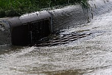
Urban runoff is surface runoff of rainwater, landscape irrigation, and car washing created by urbanization. Impervious surfaces are constructed during land development. During rain, storms, and other precipitation events, these surfaces, along with rooftops, carry polluted stormwater to storm drains, instead of allowing the water to percolate through soil. This causes lowering of the water table and flooding since the amount of water that remains on the surface is greater. Most municipal storm sewer systems discharge untreated stormwater to streams, rivers, and bays. This excess water can also make its way into people's properties through basement backups and seepage through building wall and floors.
The Hydrologic Modeling System (HEC-HMS) is designed to simulate the precipitation-runoff processes of dendritic drainage basins. It is designed to be applicable in a wide range of geographic areas for solving the widest possible range of problems. This includes large river basin water supply and flood hydrology, and small urban or natural watershed runoff. Hydrographs produced by the program are used directly or in conjunction with other software for studies of water availability, urban drainage, flow forecasting, future urbanization impact, reservoir spillway design, flood damage reduction, floodplain regulation, and systems operation.
GSSHA is a two-dimensional, physically based watershed model developed by the Engineer Research and Development Center of the United States Army Corps of Engineers. It simulates surface water and groundwater hydrology, erosion and sediment transport. The GSSHA model is used for hydraulic engineering and research, and is on the Federal Emergency Management Agency (FEMA) list of hydrologic models accepted for use in the national flood insurance program for flood hydrograph estimation. Input is best prepared by the Watershed Modeling System interface, which effectively links the model with geographic information systems (GIS).
The following outline is provided as an overview of and topical guide to hydrology:

Vflo is a commercially available, physics-based distributed hydrologic model generated by Vieux & Associates, Inc. Vflo uses radar rainfall data for hydrologic input to simulate distributed runoff. Vflo employs GIS maps for parameterization via a desktop interface. The model is suited for distributed hydrologic forecasting in post-analysis and in continuous operations. Vflo output is in the form of hydrographs at selected drainage network grids, as well as distributed runoff maps covering the watershed. Model applications include civil infrastructure operations and maintenance, stormwater prediction and emergency management, continuous and short-term surface water runoff, recharge estimation, soil moisture monitoring, land use planning, water quality monitoring, and water resources management.
In hydrology, routing is a technique used to predict the changes in shape of a hydrograph as water moves through a river channel or a reservoir. In flood forecasting, hydrologists may want to know how a short burst of intense rain in an area upstream of a city will change as it reaches the city. Routing can be used to determine whether the pulse of rain reaches the city as a deluge or a trickle.

Low-impact development (LID) is a term used in Canada and the United States to describe a land planning and engineering design approach to manage stormwater runoff as part of green infrastructure. LID emphasizes conservation and use of on-site natural features to protect water quality. This approach implements engineered small-scale hydrologic controls to replicate the pre-development hydrologic regime of watersheds through infiltrating, filtering, storing, evaporating, and detaining runoff close to its source. Green infrastructure investments are one approach that often yields multiple benefits and builds city resilience.


