Sahara pump theory

Last updated
Carvings of fauna common in the Sahara during the wet phase, found at Tassili in the central Sahara Tassili art.jpg
Carvings of fauna common in the Sahara during the wet phase, found at Tassili in the central Sahara

The Sahara pump theory is a hypothesis that explains how flora and fauna migrated between Eurasia and Africa via a land bridge in the Levant region. It posits that extended periods of abundant rainfall lasting many thousands of years (pluvial periods) in Africa are associated with a "wet-green Sahara" phase, during which larger lakes and more rivers existed. [1] This caused changes in the flora and fauna found in the area. Migration along the river corridor was halted when, during a desert phase 1.8–0.8 million years ago (mya), the Nile ceased to flow completely[ clarification needed ] [2] [3] and possibly flowed only temporarily in other periods [4] due to the geologic uplift (Nubian Swell) of the Nile River region.

Contents

Mechanism

During periods of a wet or Green Sahara , the Sahara and Arabia become a savanna grassland and African flora and fauna become common. [5] [ unreliable source? ] Following inter-pluvial arid periods, the Sahara area then reverts to desert conditions, usually as a result of the retreat of the West African Monsoon southwards. Evaporation exceeds precipitation, the level of water in lakes like Lake Chad falls, and rivers become dry wadis. Flora and fauna previously widespread as a result retreat northwards to the Atlas Mountains, southwards into West Africa, or eastwards into the Nile Valley and thence either southeast to the Ethiopian Highlands and Kenya or northeast across the Sinai into Asia. This separates populations of some of the species in areas with different climates, forcing them to adapt, possibly giving rise to allopatric speciation.[ citation needed ]

Plio-Pleistocene

The Plio-Pleistocene migrations to Africa included the Caprinae in two waves at 3.2 Ma and 2.7–2.5 Ma; Nyctereutes at 2.5 Ma, and Equus at 2.3 Ma. Hippotragus migrated at 2.6 Ma from Africa to the Siwaliks of the Himalayas. Asian bovids moved to Europe and to and from Africa. The primate Theropithecus experienced contraction and its fossils are found only in Europe and Asia, while Homo and Macaca settled wide ranges. [6]

185,000–20,000 years ago

Between about 133 and 122 thousand years ago (kya), the southern parts of the Saharan-Arabian Desert experienced the start of the Abbassia Pluvial, a wet period with increased monsoonal precipitation, around 100-200 mm/year. This allowed Eurasian biota to travel to Africa and vice versa. [7] The growth of speleothems (which requires rainwater) was detected in Hol-Zakh, Ashalim, Even-Sid, Ma'ale-ha-Meyshar, Ktora Cracks, Nagev Tzavoa Cave. In Qafzeh and Es Skuhl caves, where at that time precipitation was 600–1000 mm/year, the remains of Qafzeh-Skhul type anatomically modern humans are dated from this period, but human occupation seems to end in the later arid period.

The Red Sea coastal route was extremely arid before 140 and after 115 kya. Slightly wetter conditions appear at 90–87 kya, but it still was just one tenth the rainfall around 125 kya. Speleothems are detected only in Even-Sid-2. [7]

In the southern Negev Desert speleothems did not grow between 185–140 kya (MIS 6), 110–90 (MIS 5.4–5.2), nor after 85 kya nor during most of the interglacial period (MIS 5.1), the glacial period and Holocene. This suggests that the southern Negev was arid to hyper-arid in these periods. [7]

The coastal route around the western Mediterranean may have been open at times during the last glacial; speleothems grew in Hol-Zakh and in Nagev Tzavoa Caves. Comparison of speleothem formation with calcite horizons suggests that the wet periods were limited to only tens or hundreds of years. [7]

From 60–30 kya there were extremely dry conditions in many parts of Africa. [8]

Last Glacial Maximum

An example of the Saharan pump has occurred after the Last Glacial Maximum (LGM). During the Last Glacial Maximum the Sahara desert was more extensive than it is now with the extent of the tropical forests being greatly reduced. [9] During this period, the lower temperatures reduced the strength of the Hadley Cell whereby rising tropical air of the Inter-Tropical Convergence Zone (ITCZ) brings rain to the tropics, while dry descending air, at about 20 degrees north, flows back to the equator and brings desert conditions to this region. This phase is associated with high rates of wind-blown mineral dust, found in marine cores that come from the north tropical Atlantic.

Around 12,500 BC, the amount of dust in the cores in the Bølling/Allerød phase suddenly plummets and shows a period of much wetter conditions in the Sahara, indicating a Dansgaard-Oeschger (DO) event (a sudden warming followed by a slower cooling of the climate). The moister Saharan conditions had begun about 12,500 BC, with the extension of the ITCZ northward in the northern hemisphere summer, bringing moist wet conditions and a savanna climate to the Sahara, which (apart from a short dry spell associated with the Younger Dryas) peaked during the Holocene thermal maximum climatic phase at 4000 BC when mid-latitude temperatures seem to have been between 2 and 3 degrees warmer than in the recent past. Analysis of Nile River deposited sediments in the delta also shows this period had a higher proportion of sediments coming from the Blue Nile, suggesting higher rainfall also in the Ethiopian Highlands. This was caused principally by a stronger monsoonal circulation throughout the sub-tropical regions, affecting India, Arabia and the Sahara.[ citation needed ] Lake Victoria only recently became the source of the White Nile and dried out almost completely around 15 kya. [10]

The sudden subsequent movement of the ITCZ southwards with a Heinrich event (a sudden cooling followed by a slower warming), linked to changes with the El Niño-Southern Oscillation cycle, led to a rapid drying out of the Saharan and Arabian regions, which quickly became desert. This is linked to a marked decline in the scale of the Nile floods between 2700 and 2100 BC. [11] One theory proposed that humans accelerated the drying out period from 6,000–2,500 BC by pastoralists overgrazing available grassland. [12]

Human migration

The Saharan pump has been used to date a number of waves of human migration from Africa, namely: [13] [14] [15]

See also

Related Research Articles

<span class="mw-page-title-main">Kalahari Desert</span> Semi-arid sandy savanna in Southern Africa

The Kalahari Desert is a large semi-arid sandy savanna in Southern Africa extending for 900,000 square kilometres (350,000 sq mi), covering much of Botswana, as well as parts of Namibia and South Africa.

Mali is located in Africa. The history of the territory of modern Mali may be divided into:

<span class="mw-page-title-main">North Africa</span> Northernmost region of Africa

North Africa is a region encompassing the northern portion of the African continent. There is no singularly accepted scope for the region, and it is sometimes defined as stretching from the Atlantic shores of the Western Sahara in the west, to Sudan's Red Sea coast in the east.

<span class="mw-page-title-main">Pleistocene</span> First epoch of the Quaternary Period

The Pleistocene is the geological epoch that lasted from c. 2.58 million to 11,700 years ago, spanning the Earth's most recent period of repeated glaciations. Before a change was finally confirmed in 2009 by the International Union of Geological Sciences, the cutoff of the Pleistocene and the preceding Pliocene was regarded as being 1.806 million years Before Present (BP). Publications from earlier years may use either definition of the period. The end of the Pleistocene corresponds with the end of the last glacial period and also with the end of the Paleolithic age used in archaeology. The name is a combination of Ancient Greek πλεῖστος (pleîstos), meaning "most", and καινός, meaning "new".

<span class="mw-page-title-main">Sahara desert (ecoregion)</span> The ecology of the Sahara desert

The Sahara desert, as defined by the World Wide Fund for Nature (WWF), includes the hyper-arid center of the Sahara, between latitudes 18° N and 30° N. It is one of several desert and xeric shrubland ecoregions that cover the northern portion of the African continent.

<span class="mw-page-title-main">Prehistoric North Africa</span> Prehistory of North African region

The prehistory of North Africa spans the period of earliest human presence in the region to gradual onset of historicity in the Maghreb during classical antiquity. Early anatomically modern humans are known to have been present at Jebel Irhoud, in what is now Morocco, approximately 300,000 years ago. The Nile Valley region, via ancient Egypt, contributed to the Neolithic, Bronze Age and Iron Age periods of the Old World, along with the ancient Near East.
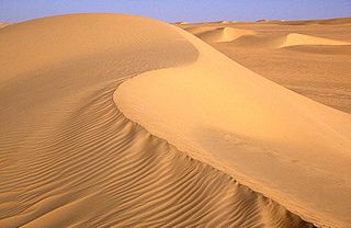
<span class="mw-page-title-main">Sahara</span> Desert on the African continent

The Sahara is a desert spanning North Africa. With an area of 9,200,000 square kilometres (3,600,000 sq mi), it is the largest hot desert in the world and the third-largest desert overall, smaller only than the deserts of Antarctica and the northern Arctic.

<span class="mw-page-title-main">Pluvial lake</span> Landlocked basin (endorheic basin)

A pluvial lake is a body of water that accumulated in a basin because of a greater moisture availability resulting from changes in temperature and/or precipitation. These intervals of greater moisture availability are not always contemporaneous with glacial periods. Pluvial lakes are typically closed lakes that occupied endorheic basins. Pluvial lakes that have since evaporated and dried out may also be referred to as paleolakes.

<span class="mw-page-title-main">Upper Paleolithic</span> Subdivision of the Paleolithic or Old Stone Age

The Upper Paleolithic is the third and last subdivision of the Paleolithic or Old Stone Age. Very broadly, it dates to between 50,000 and 12,000 years ago, according to some theories coinciding with the appearance of behavioral modernity in early modern humans, until the advent of the Neolithic Revolution and agriculture.

<span class="mw-page-title-main">Ténéré</span> Desert in Niger and Chad

The Ténéré is a desert region in south central Sahara. It comprises a vast plain of sand stretching from northeastern Niger into western Chad, occupying an area of over 400,000 square kilometres (150,000 sq mi). The Ténéré's boundaries are said to be the Aïr Mountains in the west, the Hoggar Mountains in the north, the Djado Plateau in the northeast, the Tibesti Mountains in the east, and the basin of Lake Chad in the south. The central part of the desert, the Erg du Bilma, is centred at approximately 17°35′N10°55′E. It is the locus of the Neolithic Tenerian culture.

<span class="mw-page-title-main">4.2-kiloyear event</span> Severe climatic event starting around 2200 BC

The 4.2-kiloyear BP aridification event, also known as the 4.2 ka event, was one of the most severe climatic events of the Holocene epoch. It defines the beginning of the current Meghalayan age in the Holocene epoch.
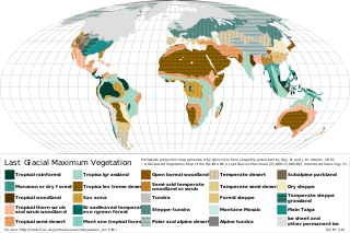
<span class="mw-page-title-main">Climate of Mount Kenya</span>

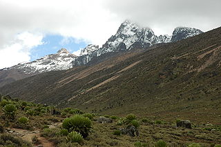
The climate of Mount Kenya has played a critical role in the development of the mountain, influencing the topography and ecology amongst other factors. The area around Mount Kenya is covered by a comparably large number of weather station data with long measurements series and thus the climate is well recorded. It has a typical equatorial mountain climate which Hedberg described as winter every night and summer every day.

The Mousterian Pluvial is a mostly obsolete term for a prehistoric wet and rainy (pluvial) period in North Africa. It was described as beginning around 50,000 years before the present (BP), lasting roughly 20,000 years, and ending ca. 30,000 BP.

The Abbassia Pluvial was an extended wet and rainy period in the climate history of North Africa, lasting from c. 120,000 to 90,000 years ago. As such it spans the transitional period connecting the Lower and Middle Paleolithic.

The prehistory of Africa spans from the earliest human presence in Africa until the ancient period in the history of Africa.

<span class="mw-page-title-main">South Saharan steppe and woodlands</span> South Sahara desert ecoregion

The South Saharan steppe and woodlands, also known as the South Sahara desert, is a deserts and xeric shrublands ecoregion of northern Africa. This band is a transitional region between the Sahara's very arid center to the north, and the wetter Sahelian Acacia savanna ecoregion to the south. In pre-modern times, the grasslands were grazed by migratory gazelles and other ungulates after the rainfalls. More recently, over-grazing by domestic livestock have degraded the territory. Despite the name of the ecoregion, there are few 'woodlands' in the area; those that exist are generally acacia and shrubs along rivers and in wadis.

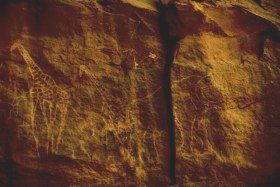
This timeline of prehistory covers the time from the appearance of Homo sapiens approximately 315,000 years ago in Africa to the invention of writing, over 5,000 years ago, with the earliest records going back to 3,200 BC. Prehistory covers the time from the Paleolithic to the beginning of ancient history.

North African climate cycles have a unique history that can be traced back millions of years. The cyclic climate pattern of the Sahara is characterized by significant shifts in the strength of the North African Monsoon. When the North African Monsoon is at its strongest, annual precipitation and consequently vegetation in the Sahara region increase, resulting in conditions commonly referred to as the "green Sahara". For a relatively weak North African Monsoon, the opposite is true, with decreased annual precipitation and less vegetation resulting in a phase of the Sahara climate cycle known as the "desert Sahara".

<span class="mw-page-title-main">African humid period</span> Holocene climate period during which northern Africa was wetter than today

The African humid period is a climate period in Africa during the late Pleistocene and Holocene geologic epochs, when northern Africa was wetter than today. The covering of much of the Sahara desert by grasses, trees and lakes was caused by changes in the Earth's axial tilt; changes in vegetation and dust in the Sahara which strengthened the African monsoon; and increased greenhouse gases. During the preceding Last Glacial Maximum, the Sahara contained extensive dune fields and was mostly uninhabited. It was much larger than today, and its lakes and rivers such as Lake Victoria and the White Nile were either dry or at low levels. The humid period began about 14,600–14,500 years ago at the end of Heinrich event 1, simultaneously to the Bølling–Allerød warming. Rivers and lakes such as Lake Chad formed or expanded, glaciers grew on Mount Kilimanjaro and the Sahara retreated. Two major dry fluctuations occurred; during the Younger Dryas and the short 8.2 kiloyear event. The African humid period ended 6,000–5,000 years ago during the Piora Oscillation cold period. While some evidence points to an end 5,500 years ago, in the Sahel, Arabia and East Africa, the end of the period appears to have taken place in several steps, such as the 4.2-kiloyear event.

<span class="mw-page-title-main">Mundafan</span> Former lake in Saudi Arabia

Mundafan was a former lake in Saudi Arabia, within presently desert-like areas. It formed during the Pleistocene and Holocene, when orbitally mediated changes in climate increased monsoon precipitation in the peninsula, allowing runoff to form a lake with a maximum area of 300 square kilometres (120 sq mi). It was populated by fishes and surrounded by reeds and savanna, which supported human populations.

References

  1. van Zinderen-Bakker E. M. (1962-04-14). "A Late-Glacial and Post-Glacial Climatic Correlation between East Africa and Europe". Nature. 194 (4824): 201–203. Bibcode:1962Natur.194..201V. doi:10.1038/194201a0. S2CID   186244151.
  2. "Structural Controls Of The Egyptian Nile". Archived from the original on 2010-08-31. Retrieved 2009-06-27.
  3. Lansbery, Leslie (2011). Geological and geomorphological evolution of the Egyptian Nile between Aswan and Kom Ombo: A remote sensing and field study approach (MS). Missouri University of Science and Technology.
  4. Williams, Martin A.J.; Talbot, Michael R. (2009). "Late Quaternary Environments in the Nile Basin". The Nile. Monographiae Biologicae. Vol. 89. pp. 61–72. doi:10.1007/978-1-4020-9726-3_4. ISBN   978-1-4020-9725-6.
  5. Walker, Stephen (8 October 2013). "Gilf Kebir". Orbit: Earth's Extraordinary Journey. Retrieved 20 December 2013.
  6. Hughesm, Jk; Elton, S; O'Regan, Hj (Jan 2008). "Theropithecus and 'Out of Africa' dispersal in the Plio-Pleistocene". Journal of Human Evolution. 54 (1): 43–77. doi:10.1016/j.jhevol.2007.06.004. ISSN   0047-2484. PMID   17868778.
  7. 1 2 3 4 Vaks, Anton; Bar-Matthews, Miryam; Ayalon, Avner; Matthews, Alan; Halicz, Ludwik; Frumkin, Amos (2007). "Desert speleothems reveal climatic window for African exodus of early modern humans" (PDF). Geology. 35 (9): 831. Bibcode:2007Geo....35..831V. doi:10.1130/G23794A.1. Archived from the original (PDF) on 2011-07-21.
  8. Mellars, P. (Jun 2006). "Why did modern human populations disperse from Africa ca. 60,000 years ago? A new model". Proceedings of the National Academy of Sciences. 103 (25): 9381–9386. Bibcode:2006PNAS..103.9381M. doi: 10.1073/pnas.0510792103 . ISSN   0027-8424. PMC   1480416 . PMID   16772383.
  9. Adams, Jonathan. "Africa during the last 150,000 years". Environmental Sciences Division, ORNL Oak Ridge National Laboratory. Archived from the original on 2006-05-01.
  10. Stager, J. C.; Johnson, T. C. (2008). "The late Pleistocene desiccation of Lake Victoria and the origin of its endemic biota". Hydrobiologia . 596: 5–16. doi:10.1007/s10750-007-9158-2. S2CID   42372016.
  11. Burroughs, William J. (2007) "Climate Change in Prehistory: the end of the reign of chaos" (Cambridge University Press)
  12. Boissoneault, Lorraine (2017-03-24). "What Really Turned the Sahara Desert From a Green Oasis Into a Wasteland?". Smithsonian. Retrieved 2017-08-15.
  13. Stephen, Stokes. "Chronology, Adaptation and Environment of the Middle Palaeolithic in Northern Africa". Human Evolution, Cambridge University. Archived from the original on 2012-03-20. Retrieved 2013-01-15.
  14. Hoffman, Michael (September 2015). "1". Brain Beat: Scientific Foundations and Evolutionary Perspectives of Brain Health. New York, USA: Page Publishing, Inc. ISBN   978-1682133194.
  15. Harcourt, Alexander H. (2015) "Humankind: how biology and geography shape human diversity" (Pegasus Books)
  16. Anderson, Helen (2016) "Chariots in Saharan Rock Art: an aesthetic and cognitive review" (Journal of Social Archaeology Vol 16 no. 3)