Diprotodon is an extinct genus of large marsupials native to Australia from the Pleistocene epoch. It is considered one of Australia's core species of "megafauna", which ranged throughout the continent during the Pleistocene. The genus is currently considered monotypic, containing only Diprotodon optatum, the largest known marsupial to have ever existed. The word diprotodon is constructed from the Ancient Greek words for 'two forward teeth'. Diprotodon existed from about 1.6 million years ago until extinction some 44,000 years ago.

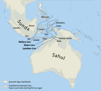
Wallacea is a biogeographical designation for a group of mainly Indonesian islands separated by deep-water straits from the Asian and Australian continental shelves. Wallacea includes Sulawesi, the largest island in the group, as well as Lombok, Sumbawa, Flores, Sumba, Timor, Halmahera, Buru, Seram, and many smaller islands. The islands of Wallacea lie between the Sunda Shelf to the west, and the Sahul Shelf including Australia and New Guinea to the south and east. The total land area of Wallacea is 347,000 km2 (134,000 sq mi).

The term Australian megafauna refers to a number of megafauna in Australia during the Pleistocene Epoch. Most of these species became extinct during the latter half of the Pleistocene, and the roles of human and climatic factors in their extinction are contested.

Near Oceania is the part of Oceania settled 35,000 years ago, comprising Australia, New Guinea, and northwestern Island Melanesia: the Bismarck Archipelago and the Solomon Islands.
Geologically, the Sunda Shelf is a southeastern extension of the continental shelf of Mainland Southeast Asia. Major landmasses on the shelf include the Bali, Borneo, Java, Madura, and Sumatra, as well as their surrounding smaller islands. It covers an area of approximately 1.85 million km2. Sea depths over the shelf rarely exceed 50 metres and extensive areas are less than 20 metres resulting in strong bottom friction and strong tidal friction. Steep undersea gradients separate the Sunda Shelf from the Philippines, Sulawesi, and the Lesser Sunda Islands.

The prehistory of Australia is the period between the first human habitation of the Australian continent and the colonisation of Australia in 1788, which marks the start of consistent written documentation of Australia. This period has been variously estimated, with most evidence suggesting that it goes back between 50,000 and 65,000 years.

The Late Pleistocene is an unofficial age in the international geologic timescale in chronostratigraphy, also known as Upper Pleistocene from a stratigraphic perspective. It is intended to be the fourth division of the Pleistocene Epoch within the ongoing Quaternary Period. It is currently estimated to span the time between c. 129,000 and c. 11,700 years ago. The Late Pleistocene equates to the proposed Tarantian Age of the geologic time scale, preceded by the officially ratified Chibanian and succeeded by the officially ratified Greenlandian. The estimated beginning of the Tarantian is the start of the Eemian interglacial period. It is held to end with the termination of the Younger Dryas, some 11,700 years ago when the Holocene Epoch began.

Aboriginal Australians are the various Indigenous peoples of the Australian mainland and many of its islands, such as Tasmania, Fraser Island, Hinchinbrook Island, the Tiwi Islands, and Groote Eylandt, but excluding the Torres Strait Islands. The term Indigenous Australians refers to Aboriginal Australians and Torres Strait Islanders collectively. It is generally used when both groups are included in the topic being addressed. Torres Strait Islanders are ethnically and culturally distinct, despite extensive cultural exchange with some of the Aboriginal groups. The Torres Strait Islands are mostly part of Queensland but have a separate governmental status.

Cuddie Springs is a notable archaeological and paleontological site in the semi-arid zone of central northern New South Wales, Australia, near Carinda in Walgett Shire. Cuddie Springs is an open site, with the fossil deposits preserved in a claypan on the floor of an ancient ephemeral lake. The claypan fills with water after local rainstorms and often takes months to dry, a fact which facilitated the survival of fossils over a long period of time.
Australian archaeology is a large sub-field in the discipline of archaeology. Archaeology in Australia takes three main forms: Aboriginal archaeology, historical archaeology, and maritime archaeology. Bridging these sub-disciplines is the important concept of cultural heritage management, which encompasses Aboriginal and Torres Strait Islander sites, historical sites, and maritime sites.
Geologically, the Sahul Shelf is part of the continental shelf of the Australian continent, lying off the northwest coast of Mainland Australia.
Peter Dixon Hiscock is an Australian archaeologist. Born in Melbourne, he obtained a PhD from the University of Queensland. Since 2013, he has been the Tom Austen Brown Professor of Australian Archaeology at the University of Sydney, having previously held a position in the School of Archaeology and Anthropology at the Australian National University.

The continent of Australia is a continent in the Southern Hemisphere. The continent is sometimes defined as mainland Australia and Tasmania along with smaller surrounding islands. At other times the continent is defined as including the island of New Guinea and its surrounding smaller islands along with Australia.

New Guinea is the world's second-largest island, and with an area of 785,753 km2 (303,381 sq mi), the largest island in the Southern Hemisphere. Located in Oceania in the southwestern Pacific Ocean, it is separated by the 150 km wide Torres Strait from Australia. Numerous smaller islands are located to the west and east. The eastern half of the island is the major land mass of the independent state of Papua New Guinea. The western half, known as Western New Guinea, forms a part of Indonesia and is organized as the provinces of Papua and West Papua. The largest cities on the island are Jayapura and Port Moresby.

Prehistoric Indonesia is a prehistoric period in the Indonesian archipelago that spanned from the Pleistocene period to about the 4th century CE when the Kutai people produced the earliest known stone inscriptions in Indonesia. Unlike the clear distinction between prehistoric and historical periods in Europe and the Middle East, the division is muddled in Indonesia. This is mostly because Indonesia's geographical conditions as a vast archipelago caused some parts — especially the interiors of distant islands — to be virtually isolated from the rest of the world. West Java and coastal Eastern Borneo, for example, began their historical periods in the early 4th century, but megalithic culture still flourished and script was unknown in the rest of Indonesia, including in Nias, Batak, and Toraja. The Papuans on the Indonesian part of New Guinea island lived virtually in the Stone Age until their first contacts with modern world in the early 20th century. Even today living megalithic traditions still can be found on the island of Sumba and Nias.

The Kow Swamp archaeological site comprises a series of late Pleistocene burials within the lunette of the eastern rim of a former lake known as Kow Swamp. The site is 10 kilometres (6 mi) south-east of Cohuna in the central Murray River valley, in northern Victoria, at 35.953553°S 144.318123°E. The site is significant for archaeological excavations by Alan Thorne between 1968 and 1972 which recovered the partial skeletal remains of more than 22 individuals.
Joseph Benjamin Birdsell of Harvard University and UCLA was an anthropologist who studied Aboriginal Australians.
James F. O'Connell is Distinguished Professor Emeritus of Anthropology at the University of Utah. He is a member of the National Academy of Sciences of the United States of America and is on the editorial board of the Proceedings of the National Academy of Sciences.

Madjedbebe is a sandstone rock shelter in Arnhem Land, in the Northern Territory of Australia, said to be the site of the oldest evidence of human habitation in the country. It is located about 50 kilometres (31 mi) from the coast. It is part of the lands traditionally inhabited by the Mirarr, an Aboriginal Australian clan of the Gaagudju people, of the Gunwinyguan language group. Although it is surrounded by the World Heritage Listed Kakadu National Park, Madjedbebe itself is located within the Jabiluka Mineral Leasehold.