Saint-Aventin

Last updated

Saint-Aventin
Saint-Aventin village.JPG
A general view of Saint-Aventin
Blason ville fr Saint-Aventin (Haute-Garonne).svg
Location of Saint-Aventin
Saint-Aventin
France location map-Regions and departements-2016.svg
Red pog.svg
Saint-Aventin
Languedoc-Roussillon-Midi-Pyrenees region location map.svg
Red pog.svg
Saint-Aventin
Coordinates: 42°48′26″N0°32′49″E / 42.8072°N 0.5469°E / 42.8072; 0.5469
Country France
Region Occitania
Department Haute-Garonne
Arrondissement Saint-Gaudens
Canton Bagnères-de-Luchon
Government
  Mayor (20202026) Jean-Claude Tiné [1]
Area
1
17.4 km2 (6.7 sq mi)
Population
 (2022) [2]
63
  Density3.6/km2 (9.4/sq mi)
Time zone UTC+01:00 (CET)
  Summer (DST) UTC+02:00 (CEST)
INSEE/Postal code
31470 /31110
Elevation679–2,676 m (2,228–8,780 ft)
(avg. 929 m or 3,048 ft)
1 French Land Register data, which excludes lakes, ponds, glaciers > 1 km2 (0.386 sq mi or 247 acres) and river estuaries.

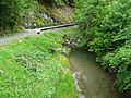
Saint-Aventin is a commune in the Haute-Garonne department in southwestern France.

Contents

The commune of Saint-Aventin is located in the heart of the Pyrenees, and extends from the Larboust Valley in the north to the Spanish border in the South. The highest point is the Sacroux peek at 2,676 metres. The municipal territory hosts the Luchon-Superbagnères winter sports facilities, accessible only from Bagnères-de-Luchon by road or Cable car. The village of Saint-Aventin, is located in the Larboust Valley, 52 km south of Saint-Gaudens and 5 km west of Bagnères-de-Luchon. The population density is 5.3per/km²

Population

Historical population
YearPop.±%
1793242    
1800176−27.3%
1806259+47.2%
1821340+31.3%
1831386+13.5%
1841400+3.6%
1846415+3.8%
1851410−1.2%
1856390−4.9%
1861410+5.1%
1866360−12.2%
1878320−11.1%
1886295−7.8%
1891282−4.4%
1896284+0.7%
1901283−0.4%
YearPop.±%
1906288+1.8%
1911291+1.0%
1921228−21.6%
1926224−1.8%
1931208−7.1%
1936200−3.8%
1946195−2.5%
1954162−16.9%
1962128−21.0%
1968155+21.1%
1975149−3.9%
1982115−22.8%
199098−14.8%
199996−2.0%
200888−8.3%
201192+4.5%
Source: EHESS [3]

Land Marks

Saint Aventin Church

The Romanesque Church Saint-Aventin dates from the 11th or 12th century, has two bell towers, a porch decorated with sculptures, and capitals showing scenes of the life and martyrdom of saint Aventin.
The exterior walls have incorporated stone from previous buildings that reuse of stelae and pagan altars dedicated to Pyrenean gods, including Abellio and Aherbelst. Inside the church are monumental paintings, a baptismal font and a wrought iron altar. The Church has been classified historical monument since 1840. [4]

See also

References

  1. "Répertoire national des élus: les maires". data.gouv.fr, Plateforme ouverte des données publiques françaises (in French). 9 August 2021.
  2. "Populations de référence 2022" (in French). The National Institute of Statistics and Economic Studies. 19 December 2024.
  3. Des villages de Cassini aux communes d'aujourd'hui: Commune data sheet Saint-Aventin, EHESS (in French).
  4. Base Mérimée : PA00094445 , Ministère français de la Culture. (in French)