(Upward from the mouth) rivière aux Ours, cours d'eau Notre-Dame, Tourilli River, décharge du lac Ball, décharge des lacs Nolin et Johnson, décharge du lac Noyade, décharge des lacs Carreau et Coeur.
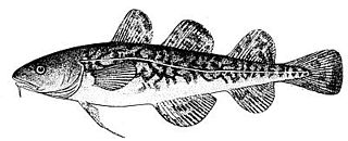
It is well known for ice fishing, with the primary catch being Tomcod, (poulamon in French), during the winter at Ste-Anne-de-la-Pérade. A small village builds up from the end of December to mid-February.
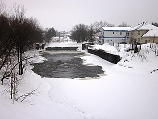
It is also regionally known for flooding, especially in St-Raymond, and sometimes in St-Casimir.
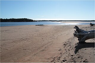
The river has its source in the Reserve des Laurentides and flows through St-Raymond, St-Casimir and Ste-Anne-de-la-Pérade to empty into the north shore of the Saint Lawrence.
Toponymy
The origin of the name of the river is unknown[1]. Samuel de Champlain gave it the name of Sainte-Marie river in 1609 without specifying its reasons[1]. It was registered under the name of Sainte-Anne river on the map of Jean Bourdon of 1641, an appellation which quickly became essential[1]. The Hurons, meanwhile, call it "Telahiar"[1].
The whole is covered with marine and continental deposits from the Quaternary, the thickness of which is approximately 40 metres (130ft) in the St. Lawrence Lowlands and less than 5 metres (16ft) in the Laurentians[7].
The river is also recognized as an important spawning ground for the [Atlantic tomcod] (Microgadus tomcod). There are between 600 and {800 million of individuals who come to breed in the river between December and February, two million of which are fished each year[13]. The spawning ground would have been created in 1894 by a major landslide at Saint-Alban, giving the river a bottom of sand and gravel ideal for the reproduction of fish[12].
The Atlantic tomcod population was rediscovered in the river in 1938[14]. Ice fishing quickly became a popular activity, developing a village up to 1200 huts[14]. The combined pressure of commercial fishing and sport fishing caused the decline of the fish population[15]. To remedy this decline, a moratorium on commercial fishing was decreed in 1992 which enabled the tomcod population to recover[14].
Layout
Dam at Ford Fall, Sainte-Anne river, close to Sainte-Christine-d'Auvergne.
There are five dams on the Sainte-Anne river, three of which are used for hydroelectric production[16]. These are the power stations of Saint-Alban (8.2 megawatts (11,000hp)), Chutes-à-Gorry (10.76 megawatts (14,430hp)) and Glenford (4.2 megawatts (5,600hp))[16].
Les Chenaux is a regional county municipality in central Quebec, Canada, in the Mauricie region. The seat is in Saint-Luc-de-Vincennes. It is located adjacent on the east of Trois-Rivières on the Saint Lawrence River. It has a land area of 872.04 square kilometres (336.70 sq mi) and a population of 17,865 inhabitants in the Canada 2011 Census. Its largest community is the parish of Notre-Dame-du-Mont-Carmel.
Saint-Casimir is a small village of about 1800 people in the Portneuf Regional County Municipality in the province of Quebec, Canada. It is located on the Sainte-Anne River, about 80 kilometres (50 mi) southwest of Quebec City and 50 kilometres (31 mi) northeast of Trois-Rivières.
Route 354 is an east-west regional road in Quebec, Canada, starting from Route 159 north of Ste-Anne de la Pérade going to St-Raymond. It follows the Rivière Ste-Anne on the south shore most of the time. It is 55 km long, and overlaps Route 363 about 4 km in St-Casimir. Between St-Casimir and Ste-Anne-de-la-Pérade, it is named the "Rapide Nord", where it is the only part it is on the north shore of the river. It becomes rue Tessier Ouest in the village zone. This section was really bad until fall 2005, when it was newly paved on 12 km. Once it crosses the Rivière Ste-Anne, in the village of St-Casimir, it takes the name of rue (street) Notre-Dame.
The Jacques-Cartier River is a river in the province of Quebec, Canada. It is 161 km long and its source is Jacques-Cartier Lake in Laurentides Wildlife Reserve, and flows in a predominantly southern direction before ending in the Saint Lawrence River at Donnacona, about 30 km upstream from Quebec City.
The Yamaska River is a river in southern Quebec, Canada.
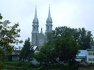
Sainte-Anne-de-la-Pérade is a municipality in the Les Chenaux Regional County Municipality, in the Mauricie region of the province of Quebec in Canada. The town is located near the mouth of the Sainte-Anne River along the Chemin du Roy, a historic segment of Quebec Route 138 that stretches from near Montreal to Quebec City.
Microgadus tomcod, also commonly known as frostfish, Atlantic tomcod or winter cod, is a type of cod found in North American coastal waters from the Gulf of St. Lawrence, St. Lawrence River and northern Newfoundland, south to Virginia.
Saint-Charles River is a river of Quebec (Canada), which passes through Quebec City. Its Huron-Wendat name is Akiawenrahk.
Batiscanie is the watershed of the Batiscan River, located in the administrative region of Mauricie, Quebec, Canada, covering 4690 km² on the North Shore of the St. Lawrence River. The area covered by Batiscanie is 53% in the administrative région of Mauricie and 47% in the administrative region of the Capitale-Nationale.
The Lordship of Sainte-Anne-de-la-Pérade was located on the north shore of St. Lawrence river, between Trois-Rivières and Quebec City in the province of Quebec, Canada. The southern front of the manor was on the edge of St. Lawrence river. The depth of the lordship was heading north, parallel to the Lordship of Batiscan. The northern boundary of the Lordship of Sainte-Anne-de-la-Perade stopped at the north-western boundary of St. Joseph row, in Sainte-Thècle. In comparison, the lordship of Batiscan spanned 20 "lieues", beyond the Saint-Maurice River. The western boundary of the manor cut the Batiscan river at the rapids of Manitou, between Saint-Adelphe and Saint-Stanislas. The estates of the north shore of St. Lawrence river fell within the stately administrative division of Trois-Rivières.
The Zec Batiscan-Neilson is a "zone d'exploitation contrôlée", located in the unorganized territory of Lac-Blanc, in Portneuf Regional County Municipality, in the administrative area of the Capitale-Nationale, on the north shore of St. Lawrence River, in Quebec, Canada.
The Noire River flows in the municipality of Saint-Alban and Saint-Casimir, in the Portneuf Regional County Municipality, in the administrative region of Capitale-Nationale, in Quebec, in Canada.
Aux Rochers River, is a river in Sept-Rivières Regional County Municipality, Côte-Nord, Quebec, Canada. It drains an area of 4,180 square kilometres (1,610 sq mi). It is a tributary of the Gulf of Saint Lawrence
The Maskinongé River is located north of the administrative region of Lanaudière and west of the administrative region of Mauricie, in Quebec, in Canada.
The Sainte-Marguerite River is a 316 kilometres (196 mi) long river in the Côte-Nord region of Quebec, Canada. It flows into the Gulf of Saint Lawrence to the west of Sept-Îles. There are traces of human activity along the river from 4,000 years ago. Pulp and paper exploitation in the river basin began in the early 20th century, followed by mining. The river has a large hydroelectric power dam, the Denis-Perron dam, that contains a reservoir that is 140 kilometres (87 mi) long.
The Watshishou River is a salmon river in the east of the Côte-Nord region of Quebec, Canada.
The Véco River is a salmon river in the Côte-Nord region of Quebec, Canada, that empties into the Gulf of Saint Lawrence. It has been dammed to supply a hydroelectric power plant. The shoreline around the mouth of the river is protected as part of a federal bird sanctuary.
The Véronique River is a river in the Côte-Nord region of the province of Quebec, Canada. It flows into the Gulf of Saint Lawrence opposite Anticosti Island.
Mingan River is a 117 kilometres (73 mi) salmon river of the Côte-Nord region of Quebec. It flows from north to south and empties into the Gulf of Saint Lawrence.
This page is based on this Wikipedia article Text is available under the CC BY-SA 4.0 license; additional terms may apply. Images, videos and audio are available under their respective licenses.