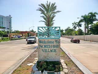
North Bay Village is a city located in Miami-Dade County, Florida. As of the 2000 census, the city had a total population of 6,733. As of 2010, the population recorded by the U.S. Census Bureau was 7,137.

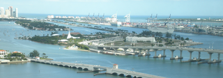
Biscayne Bay is a lagoon, with characteristics of an estuary, located on the Atlantic coast of South Florida, United States. The northern end of the lagoon is surrounded by the densely developed heart of the Miami metropolitan area, while the southern end is largely undeveloped, with a large portion of the lagoon included in Biscayne National Park. Sources differ on the extent of the lagoon. The part of the lagoon that is traditionally called "Biscayne Bay" is approximately 35 miles (56 km) long and up to 8 miles (13 km) wide, with a surface area of 573 square kilometres (221 sq mi). Various definitions may include Dumfoundling Bay, Card Sound, and Barnes Sound in a larger "Biscayne Bay", which is 60 miles (97 km) long, with a surface area of about 703 square kilometres (271 sq mi).
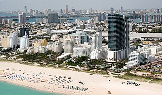
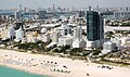
South Beach, also nicknamed SoBe, is a neighborhood in the city of Miami Beach, Florida, United States, located due east of Miami city proper between Biscayne Bay and the Atlantic Ocean. The area encompasses Miami Beach south of Dade Boulevard.

The Venetian Causeway crosses Biscayne Bay between Miami on the mainland and Miami Beach on a barrier island in south Florida. The man-made Venetian Islands and non-bridge portions of the causeway were created by materials which came from the dredging of the bay. The Venetian Causeway follows the original route of the Collins Bridge, a wooden 2.5 mi (4 km) long structure built in 1913 by John S. Collins and Carl G. Fisher which opened up the barrier island for unprecedented growth and development.
The General Douglas MacArthur Causeway is a six-lane causeway which connects downtown Miami, Florida to South Beach, Miami Beach via Biscayne Bay.

The Venetian Islands are a chain of artificial islands in Biscayne Bay in the cities of Miami and Miami Beach, Florida. The islands are, from west to east: Biscayne Island (Miami), San Marco Island (Miami), San Marino Island, Di Lido Island, Rivo Alto Island, and Belle Isle. Flagler Monument Island remains an uninhabited picnic island, originally built in 1920 as a memorial to railroad pioneer Henry Flagler. The islands are connected by bridges from the Miami mainland to Miami Beach.

Belle Isle is a neighborhood in the city of Miami Beach on an island in Biscayne Bay, Florida, United States. It is the easternmost of the Venetian Islands, a chain of artificial islands in Biscayne Bay in the cities of Miami and Miami Beach. It is home to apartment buildings, a portion of the Venetian Causeway, a city of Miami Beach park, and a hotel. It is between Rivo Alto Island and the main barrier island of Miami Beach.
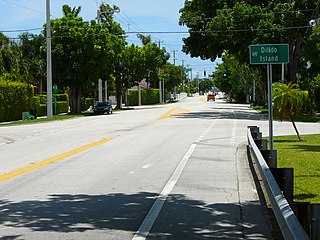
Di Lido Island is a neighborhood in the city of Miami Beach on a man-made island in Biscayne Bay, Florida, United States. It is the third island from the east of the Venetian Islands, a chain of artificial islands in Biscayne Bay in the cities of Miami and Miami Beach. It is between San Marino Island and Rivo Alto Island. It is home to residential neighborhoods and a portion of the Venetian Causeway. The unfinished artificial island Isola di Lolando from the Florida land boom of the 1920s is located near the north tip of Di Lido Island.

Flagler Memorial Island is an uninhabited artificial island of South Beach in the city of Miami Beach in Biscayne Bay, Florida, United States. A 110-foot (34 m) high obelisk with allegorical sculptures at its base stands as a monument to Miami pioneer Henry M. Flagler, and was built in the center of the freshly constructed island in memory of Flagler, who died in 1913.

Palm Island is a neighborhood in the city of Miami Beach on a man-made island in Biscayne Bay, Florida, United States; just south of Hibiscus Island. It is a residential neighborhood with high property values, solely accessible by land via the MacArthur Causeway. The entire island has an area of 82 acres (33 ha).
Rivo Alto Island is a neighborhood of in the city of Miami Beach on a man-made island in Biscayne Bay, Florida, United States. It is one of the Venetian Islands, a chain of artificial islands in Biscayne Bay in the cities of Miami and Miami Beach. It is between Di Lido Island and Belle Isle. It is home to residential neighborhoods and a portion of the Venetian Causeway.

Hibiscus Island is a neighborhood in the city of Miami Beach on a man-made island in Biscayne Bay, Florida, United States. Hibiscus Island lies just north of Palm Island. It is an exclusive residential neighborhood with relatively high property values. The island is accessible via the MacArthur Causeway.
Isle of Normandy or Normandy Island or Normandy Isles or Normandy Isle is a neighborhood of North Beach in the city of Miami Beach, Florida, United States. It is located along the eastern shore of Biscayne Bay.

The Arts & Entertainment District, or previously known as Omni, is a neighborhood of greater Downtown, Miami, Florida, United States, just south of Edgewater. It is bound roughly by North 19th Street to the north, North 10th Street to the south, North East 2nd Avenue to the west, and Biscayne Boulevard to the east.
Bayshore is a neighborhood of Mid-Beach in the city of Miami Beach, Florida, United States. It is located in the center portion of the main island that the city occupies. Originally built around Carl Fisher's Bayshore Golf and Country Club, with a course designed by H.C. Tippet which opened in 1923, the area is roughly bound by the Collins Canal to the south, 41st Street to the north, Indian Creek to the east, and Biscayne Bay to the west. The neighborhood is characterized largely by single family homes and municipal uses.

Biscayne Point is a neighborhood of North Beach in the city of Miami Beach, Florida, United States. It is located just west of the main island that the city occupies, in the area of the city referred to as North Beach. It is actually on three islands, just north of Normandy Shores. Bridges connect the three islands which are accessible from 77th Street and from 85th Street by vehicles and a from a pedestrian bridge at 80th Street.
City Center is a neighborhood of South Beach in the city of Miami Beach, Florida, United States. The area is roughly bound by Dade Boulevard and 23rd Street to the north, Lincoln Road to the south, Alton Road and Biscayne Bay to the west, and the Atlantic Ocean to the east.

Flamingo/Lummus is an urban neighborhood of South Beach in the city of Miami Beach, Florida, United States. Named for the famed Flamingo Hotel of the early 20th century, it is located in the eastern portion of the main island the city occupies. It is roughly bound by Lincoln Road to the north, 5th Street to the south, Biscayne Bay and Alton Road to the west, and Ocean Drive and Lummus Park to the east.

La Gorce is a neighborhood of Mid-Beach in the city of Miami Beach, Florida, United States. North of Indian Creek and just south of the Isle of Normandy, it is located along the shore of Biscayne Bay and include Allison and La Gorce islands.
La Gorce Island is an island within the city of Miami Beach in Miami-Dade County, Florida, United States. It is located in Biscayne Bay in the La Gorce neighborhood, in the area of the city referred to as North Beach.