West Seattle comprises two of the thirteen districts of the city of Seattle, Washington and encompasses all of Seattle west of the Duwamish River. It was incorporated as an independent town in 1902 before being annexed by Seattle five years later. Among the area's attractions are its saltwater beach parks along Elliott Bay and Puget Sound, including Alki Beach Park and Lincoln Park. The area is also known for its views of the Olympic Mountains to the west and the Cascade Range to the east. One-third of Seattle's green space and urban forest is located in West Seattle, much of it in the West Duwamish Greenbelt.

Ocean Drive is a major thoroughfare in the South Beach neighborhood of Miami Beach.
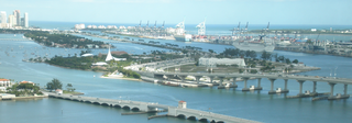
The General Douglas MacArthur Causeway is a six-lane causeway which connects Downtown, Miami, Florida and South Beach, Miami Beach via Biscayne Bay.

The Venetian Islands are a chain of artificial islands in Biscayne Bay in the cities of Miami and Miami Beach, Florida. The islands are, from west to east: Biscayne Island (Miami), San Marco Island (Miami), San Marino Island, Di Lido Island, Rivo Alto Island, and Belle Isle. Flagler Monument Island remains an uninhabited picnic island, originally built in 1920 as a memorial to railroad pioneer Henry Flagler. The islands are connected by bridges from the Miami mainland to Miami Beach.
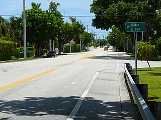
Di Lido Island is a neighborhood of South Beach in the city of Miami Beach on a man-made island in Biscayne Bay, Florida, United States. It is the third island from the east of the Venetian Islands, a chain of artificial islands in Biscayne Bay in the cities of Miami and Miami Beach. It is between San Marino Island and Rivo Alto Island. It is home to residential neighborhoods and a portion of the Venetian Causeway. The unfinished artificial island Isola di Lolando from the Florida land boom of the 1920s is located near the north tip of Di Lido Island.

Palm Island is a neighborhood of South Beach in the city of Miami Beach on a man-made island in Biscayne Bay, Florida, United States. just south of Hibiscus Island. It is a residential neighborhood with relatively high property values, solely accessible by land via the MacArthur Causeway. The entire island has an area of 82 acres.
Rivo Alto Island is a neighborhood of South Beach in the city of Miami Beach on a man-made island in Biscayne Bay, Florida, United States. It is one of the Venetian Islands, a chain of artificial islands in Biscayne Bay in the cities of Miami and Miami Beach. It is between Di Lido Island and Belle Isle. It is home to residential neighborhoods and a portion of the Venetian Causeway.
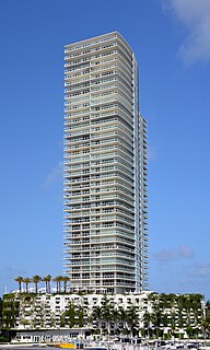
ICON at South Beach is a residential enclave tower /skyscraper in Miami Beach, Florida's South Beach. It is located directly on Biscayne Bay on the Miami Beach Marina. The tower, which opened in 2004, is 423 ft tall and has 42 floors. It is located in the "SOFI" neighborhood.
North Beach is a neighborhood of the city of Miami Beach, Florida, United States. It is the northernmost section of the city, roughly bound by 63rd Street and Indian Creek Drive to the south and 87th Terrace to the north. It collectively refers to neighborhoods including Isles of Normandy, Biscayne Point, and La Gorce.
{{Infobox settlement |name=The Roads |official_name= |other_name= |native_name= |nickname= |settlement_type=Neighborhood of Miami |total_type= |motto= |image_skyline=The Roads Miami 20100610.jpg |imagesize=300px |image_caption=Entrance to The Roads neighborhood |image_flag= |flag_size= |image_sea= |seal_size= |image_shield= |shield_size= |image_blank_emblem= |blank_emblem_type= |blank_emblem_size= |image_map=Miami neighborhoodsmap.png |mapsize=300px |map_caption=The Roads neighborhood within the City of Miami |pushpin_map= |pushpin_label_position= |pushpin_map_caption= |pushpin_mapsize= |subdivision_type = Country |subdivision_name = United States |subdivision_type1 = State |subdivision_name1 = Florida |subdivision_type2 = County |subdivision_name2 = Miami-Dade County |subdivision_type3 = City |subdivision_name3 = Miami |subdivision_type4 = |subdivision_name4 = |seat_type= |seat= |parts_type= |parts_style= |parts= |p1= |p2= |government_footnotes= |government_type= |leader_title=City of Miami Commissioner |leader_name=Joe Carollo (R) |leader_title1=Miami-Dade Commissioner |leader_name1=Eileen Higgins (D) |leader_title2=House of Representatives |leader_name2=Luis R. Garcia, Jr. (D) |leader_title3= State Senate |leader_name3=José Javier Rodríguez (Florida) (D) |leader_title4=U.S. House |leader_name4=[[Donna Shalala] (D) |established_title= |established_date= |area_magnitude= |unit_pref= |area_footnotes= |area_total_sq_mi= |area_land_sq_mi= |area_water_sq_mi= |area_water_percent= |elevation_footnotes= |elevation_m=4 |elevation_ft=13 |elevation_max_m= |elevation_max_ft= |elevation_min_m= |elevation_min_ft= |population_as_of=2010 |population_footnotes= |population_note= |population_total=7,327 |population_density_sq_mi=12687 |timezone=EST |utc_offset= -05 |timezone_DST= |utc_offset_DST= |coordinates = 25.756°N 80.205°W |postal_code_type=ZIP Code |postal_code=33129 |area_code=305, 786 |website=The Roads Association |footnotes= }}
Coral Way is a neighborhood within Miami, Florida that is defined by Coral Way, a road established by Coral Gables founder George E. Merrick during the 1920s. It is located in Miami-Dade County, Florida, United States.

Old Town is a neighborhood in the New York City borough of Staten Island, located on its East Shore. Old Town was established in August 1661 as part of New Netherland, and was the first permanent European settlement on Staten Island. Originally described as "Oude Dorpe", much of its original territory makes up what is present-day South Beach, with parts of Midland Beach and Dongan Hills. The area was settled by a group of Dutch, Walloon and French Protestants (Huguenots) led by Walloon Pierre Billiou.
Isle of Normandy or Normandy Island or Normandy Isles or Normandy Isle is a neighborhood of North Beach in the city of Miami Beach, Florida, United States. It is located along the eastern shore of Biscayne Bay.
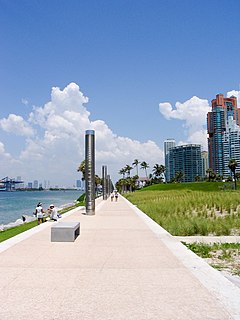
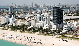
South Pointe Park, known locally as South Pointe, is a 17-acre (6.9 ha) county urban park in metropolitan Miami, in the South Beach neighborhood of Miami Beach, Florida.
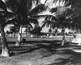
Bayshore is a neighborhood of Mid-Beach in the city of Miami Beach, Florida, United States. It is located in the center portion of the main island that the city occupies. Originally built around Carl Fisher's Bayshore Golf and Country Club, with a course designed by H.C. Tippet which opened in 1923, the area is roughly bound by the Collins Canal to the south, 41st Street to the north, Indian Creek to the east, and Biscayne Bay to the west. The neighborhood is characterized largely by single family homes and municipal uses.

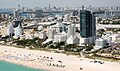
Flamingo/Lummus is an urban neighborhood of South Beach in the city of Miami Beach, Florida, United States. Named for the famed Flamingo Hotel of the early 20th century, it is located in the eastern portion of the main island the city occupies. It is roughly bound by Lincoln Road to the north, 5th Street to the south, Biscayne Bay and Alton Road to the west, and Ocean Drive and Lummus Park to the east.

La Gorce is a neighborhood of Mid-Beach in the city of Miami Beach, Florida, United States. North of Indian Creek and just south of the Isle of Normandy, it is located along the shore of Biscayne Bay and include Allison and La Gorce islands.

San Marino Island is a neighborhood of South Beach in the city of Miami Beach on a man-made island in Biscayne Bay, Florida, United States. It is one of the Venetian Islands, a chain of artificial islands in Biscayne Bay in the cities of Miami and Miami Beach. It is between San Marco Island and Di Lido Island. It is home to residential neighborhoods and a portion of the Venetian Causeway.

Mid-Beach is a section of the city of Miami Beach, Florida, United States. It is portion of the city which encompasses the area north of 23rd Street and the Indian Creek and south of Surprise Lake and 63rd Street. It collectively refers to neighborhoods including Oceanfront, Bayshore, and Nautilus.