Sand Ridge, New York

Last updated

Sand Ridge, New York
CDP
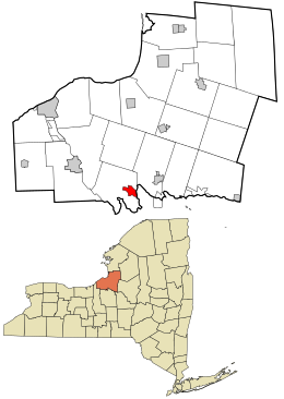
Oswego County New York incorporated and unincorporated areas Sand Ridge highlighted.svg
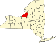
Location in Oswego County and the state of New York.
Coordinates: 43°15′8″N76°13′33″W / 43.25222°N 76.22583°W / 43.25222; -76.22583
Country United States
State New York
County Oswego
Area
[1]
  Total2.79 sq mi (7.21 km2)
  Land2.71 sq mi (7.01 km2)
  Water0.08 sq mi (0.20 km2)
Elevation
433 ft (132 m)
Population
 (2020)
  Total992
  Density366.32/sq mi (141.41/km2)
Time zone UTC-5 (Eastern (EST))
  Summer (DST) UTC-4 (EDT)
FIPS code 36-65024
GNIS feature ID1867417

Sand Ridge is a hamlet (and census-designated place) in Oswego County, New York, United States. The population was 849 at the 2010 census.

Contents

Sand Ridge is in the southern section of the Town of Schroeppel.

Geography

Sand Ridge is located at 43°15′8″N76°13′33″W / 43.25222°N 76.22583°W / 43.25222; -76.22583 (43.252294, -76.225756). [2]

According to the United States Census Bureau, the CDP has a total area of 2.5 square miles (6.5 km2), of which 2.4 square miles (6.2 km2) is land and 0.04 square miles (0.10 km2) (1.22%) is water.

Demographics

Historical population
CensusPop.Note
2020 992
U.S. Decennial Census [3]

As of the census [4] of 2000, there were 906 people, 349 households, and 242 families residing in the CDP. The population density was 375.1 inhabitants per square mile (144.8/km2). There were 438 housing units at an average density of 181.3 per square mile (70.0/km2). The racial makeup of the CDP was 96.69% White, 0.22% African American, 0.88% Native American, 0.44% Asian, 0.11% from other races, and 1.66% from two or more races. Hispanic or Latino of any race were 0.44% of the population.

There were 349 households, out of which 37.8% had children under the age of 18 living with them, 51.3% were married couples living together, 12.0% had a female householder with no husband present, and 30.4% were non-families. 26.1% of all households were made up of individuals, and 7.4% had someone living alone who was 65 years of age or older. The average household size was 2.60 and the average family size was 3.10.

In the CDP, the population was spread out, with 27.7% under the age of 18, 9.3% from 18 to 24, 31.5% from 25 to 44, 23.8% from 45 to 64, and 7.7% who were 65 years of age or older. The median age was 35 years. For every 100 females, there were 106.4 males. For every 100 females age 18 and over, there were 100.9 males.

The median income for a household in the CDP was $34,732, and the median income for a family was $43,750. Males had a median income of $33,750 versus $29,875 for females. The per capita income for the CDP was $16,893. About 7.7% of families and 7.3% of the population were below the poverty line, including 8.4% of those under age 18 and 10.9% of those age 65 or over.

Related Research Articles

<span class="mw-page-title-main">Brickerville, Pennsylvania</span> Census-designated place in Pennsylvania, United States

Brickerville is an unincorporated community and census-designated place (CDP) in Elizabeth Township, Lancaster County, Pennsylvania, United States, with a ZIP code of 17543. The population was 1,309 at the 2010 census.

<span class="mw-page-title-main">Lecanto, Florida</span> Census-designated place in Florida, US

Lecanto is an unincorporated community and census-designated place (CDP) in Citrus County, Florida, United States. As of the 2010 census it had a population of 5,882, up from 5,161 in 2000. It is home to several county government facilities such as the Citrus County Sheriff's Office and the Citrus Campus of the College of Central Florida.

<span class="mw-page-title-main">Woodville, Florida</span> CDP in Florida, United States

Woodville is a census-designated place in Leon County, Florida, United States, just south of Tallahassee, Florida. The population was 2,978 at the 2010 census. It is part of the Tallahassee, Florida Metropolitan Statistical Area. The American Civil War Battle of Natural Bridge, in March 1865, occurred in what is now Woodville, at the Natural Bridge. This is where the St. Marks River drops into a sinkhole, the Natural Bridge Sink and flows underground, reemerging .25 miles (0.40 km) later.

<span class="mw-page-title-main">Oak Ridge, Florida</span> Census-designated place in Florida, United States

Oak Ridge is a census-designated place and unincorporated area in Orange County, Florida, United States. The population was 22,685 at the 2010 census. It is part of the Orlando–Kissimmee–Sanford, Florida Metropolitan Statistical Area.

<span class="mw-page-title-main">South Gate Ridge, Florida</span> Census-designated place in Florida, United States

South Gate Ridge is a census-designated place (CDP) in Sarasota County, Florida, United States. The population was 5,688 at the 2010 census. It is part of the Bradenton–Sarasota–Venice Metropolitan Statistical Area.

Rock Island Arsenal is a census-designated place (CDP) in Rock Island County, Illinois, United States. The population was 149 at the 2010 census. The island contains the Rock Island National Cemetery.

<span class="mw-page-title-main">Housatonic, Massachusetts</span> Census-designated place in Massachusetts, United States

Housatonic is a census-designated place (CDP) in the town of Great Barrington in Berkshire County, Massachusetts. It is part of the Pittsfield, Massachusetts Metropolitan Statistical Area. The population was 1,109 at the 2010 census. It was named after the Housatonic River.

<span class="mw-page-title-main">Stone Ridge, New York</span> CDP in New York, United States

Stone Ridge is a hamlet in Ulster County, New York, United States. The population was 1,234 at the 2020 census.

<span class="mw-page-title-main">Huber Ridge, Ohio</span> Census-designated place in Ohio, United States

Huber Ridge is a census-designated place (CDP) in Blendon Township, Franklin County, Ohio, United States. The population was 4,940 at the 2020 census.

Spring Ridge is a census-designated place (CDP) in Spring Township, Berks County, Pennsylvania, United States. The population was 1,003 at the 2010 census.

<span class="mw-page-title-main">Almedia, Pennsylvania</span> Census-designated place in Pennsylvania, United States

Almedia is a census-designated place (CDP) in Columbia County, Pennsylvania, United States. It is part of Northeastern Pennsylvania. The population was 1,078 at the 2010 census. It is part of the Bloomsburg-Berwick micropolitan area.

<span class="mw-page-title-main">Fernville, Pennsylvania</span> Census-designated place in Pennsylvania, United States

Fernville is a census-designated place (CDP) in Columbia County, Pennsylvania, United States. It is part of Northeastern Pennsylvania. The population was 556 at the 2010 census. It is part of the Bloomsburg-Berwick micropolitan area.

<span class="mw-page-title-main">Lime Ridge, Pennsylvania</span> Census-designated place in Pennsylvania, United States

Lime Ridge is a census-designated place (CDP) in Columbia County, Pennsylvania, United States. It is part of Northeastern Pennsylvania. The population was 890 at the 2010 census. It is part of the Bloomsburg-Berwick micropolitan area.

Locustdale is a census-designated place (CDP) that is located on the border of Columbia and Schuylkill counties, Pennsylvania, United States. It is part of Northeastern Pennsylvania.

<span class="mw-page-title-main">Village Green-Green Ridge, Pennsylvania</span> Census-designated place in Pennsylvania, United States

Village Green-Green Ridge is a census-designated place (CDP) in Delaware County, Pennsylvania, United States. The population was 7,822 at the 2010 census, down from 8,279 at the 2000 census.

<span class="mw-page-title-main">Gilberton, Pennsylvania</span> Borough in Pennsylvania, United States

Gilberton is a borough in Schuylkill County, Pennsylvania, United States, four miles (7 km) west by south of Mahanoy City. Its population was 583 at the 2020 census, a decline from the figure of 769 tabulated in 2010. Extensive deposits of anthracite coal are in the region, and coal-mining had been practiced by many of the 4,373 people who lived there in 1900. The coal-mining industry was thriving in 1910, and 5,401 people lived in Gilberton.

<span class="mw-page-title-main">Wanblee, South Dakota</span> Census-designated place in South Dakota, United States

Wanblee is a census-designated place on the Pine Ridge Indian Reservation, located in Jackson County, South Dakota, United States. The population was 674 at the 2020 census, virtually all of whom are members of the Oglala band of Lakota Sioux. Wanbli is the Lakota word for eagle, and the town was named for its proximity to Wanbli hohpi paha. Wanblee is a few miles directly northeast of the North American continental pole of inaccessibility.

<span class="mw-page-title-main">Oglala, South Dakota</span> CDP in South Dakota, United States

Oglala is a census-designated place (CDP) in West Oglala Lakota Unorganized Territory equivalent, Oglala Lakota County, South Dakota, United States. The population was 1,282 at the 2020 census. Its location is in the northwest of the Pine Ridge Indian Reservation.

<span class="mw-page-title-main">Siesta Shores, Texas</span> CDP in Texas, United States

Siesta Shores is a census-designated place (CDP) in Zapata County, Texas, United States. The population was 1,382 at the 2010 census.

<span class="mw-page-title-main">Minetto (CDP), New York</span> CDP in New York, United States

Minetto is a hamlet in Oswego County, New York, United States. The population was 1,069 at the 2010 census.

References

  1. "ArcGIS REST Services Directory". United States Census Bureau. Retrieved September 20, 2022.
  2. "US Gazetteer files: 2010, 2000, and 1990". United States Census Bureau. February 12, 2011. Retrieved April 23, 2011.
  3. "Census of Population and Housing". Census.gov. Retrieved June 4, 2016.
  4. "U.S. Census website". United States Census Bureau . Retrieved January 31, 2008.