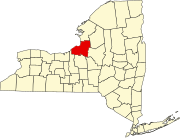
Minetto (CDP), New York

Last updated

Minetto, New York
CDP
Oswego County New York incorporated and unincorporated areas Minetto highlighted.svg
Location in Oswego County and the state of New York.
Coordinates: 43°23′47″N76°28′28″W / 43.39639°N 76.47444°W / 43.39639; -76.47444
Country United States
State New York
County Oswego
Area
[1]
  Total4.01 sq mi (10.40 km2)
  Land3.75 sq mi (9.72 km2)
  Water0.26 sq mi (0.68 km2)
Elevation
325 ft (99 m)
Population
 (2020)
  Total1,262
  Density336.35/sq mi (129.85/km2)
Time zone UTC-5 (Eastern (EST))
  Summer (DST) UTC-4 (EDT)
ZIP code
13115
Area code 315
FIPS code 36-47680
GNIS feature ID0957403

Minetto is a hamlet (and census-designated place) in Oswego County, New York, United States. The population was 1,069 at the 2010 census.

Contents

Minetto is located in the Town of Minetto at the southern city line of Oswego. It is the only settlement in the town.

Geography

Minetto is located at 43°23′46″N76°28′27″W / 43.39611°N 76.47417°W / 43.39611; -76.47417 (43.396295, -76.474378). [2]

According to the United States Census Bureau, the CDP has a total area of 3.6 square miles (9.3 km2), of which 3.4 square miles (8.7 km2) is land and 0.2 square mile (0.6 km2) (6.65%) is water.

The community is on the west bank of the Oswego River.

Demographics

Historical population
CensusPop.Note
2020 1,262
U.S. Decennial Census [3]

As of the census [4] of 2000, there were 1,086 people, 411 households, and 323 families residing in the CDP. The population density was 323.0 inhabitants per square mile (124.7/km2). There were 431 housing units at an average density of 128.2 per square mile (49.5/km2). The racial makeup of the CDP was 97.88% White, 0.28% Black or African American, 0.18% Native American, 0.83% Asian, 0.37% from other races, and 0.46% from two or more races. Hispanic or Latino of any race were 1.20% of the population.

There were 411 households, out of which 36.0% had children under the age of 18 living with them, 66.9% were married couples living together, 9.5% had a female householder with no husband present, and 21.4% were non-families. 17.3% of all households were made up of individuals, and 9.0% had someone living alone who was 65 years of age or older. The average household size was 2.64 and the average family size was 2.98.

In the CDP, the population was spread out, with 25.5% under the age of 18, 6.8% from 18 to 24, 26.0% from 25 to 44, 29.7% from 45 to 64, and 12.0% who were 65 years of age or older. The median age was 41 years. For every 100 females, there were 92.2 males. For every 100 females age 18 and over, there were 92.6 males.

The median income for a household in the CDP was $51,176, and the median income for a family was $59,844. Males had a median income of $51,806 versus $30,156 for females. The per capita income for the CDP was $23,055. About 4.8% of families and 6.7% of the population were below the poverty line, including 10.3% of those under age 18 and 7.6% of those age 65 or over.

Related Research Articles

<span class="mw-page-title-main">Kualapuʻu, Hawaii</span> Census-designated place in Hawaii, United States

Kualapuʻu is a census-designated place (CDP) on the island of Molokai in Maui County, Hawaiʻi, United States. The population was 2,110 at the 2020 census. Kualapuʻu can be literally translated as "hill overturned", but is thought to be a corruption of Puʻuʻuala: "sweet potato hill". The present settlement is a former pineapple cannery village once associated with Del Monte Foods.

<span class="mw-page-title-main">Lake of the Woods, Illinois</span> Census-designated place in Illinois, United States

Lake of the Woods is a census-designated place (CDP) in Champaign County, Illinois, United States. The population was 2403 at the 2020 census. Lake of the Woods is in Mahomet Township and mostly surrounded by the northeast part of the village of Mahomet.

Rock Island Arsenal is a census-designated place (CDP) in Rock Island County, Illinois, United States. The population was 149 at the 2010 census. The island contains the Rock Island National Cemetery.

Adams Center is a hamlet and census-designated place (CDP) in the town of Adams in Jefferson County, New York, United States. The population was 1,492 during the 2020 decennial census.

<span class="mw-page-title-main">Galeville, New York</span> Census-designated place in New York, United States

Galeville is a hamlet in Onondaga County, New York, United States. The population was 4,617 at the 2010 census.

<span class="mw-page-title-main">Seneca Knolls, New York</span> Census-designated place in New York, United States

Seneca Knolls is a hamlet in Onondaga County, New York, United States. The population was 2,011 at the 2010 census.

<span class="mw-page-title-main">Village Green, New York</span> Census-designated place in New York, United States

Village Green is a hamlet in Onondaga County, New York, United States. The population was 3,891 at the 2010 census.

<span class="mw-page-title-main">Granby, New York</span> Town in New York, United States

Granby is a town in Oswego County, New York, United States. The population was 6,821 at the 2010 census.

<span class="mw-page-title-main">Sand Ridge, New York</span> CDP in New York, United States

Sand Ridge is a hamlet in Oswego County, New York, United States. The population was 849 at the 2010 census.

<span class="mw-page-title-main">Scriba, New York</span> Town in New York, United States

Scriba is a town in Oswego County, New York, United States. The population was 6,840 at the 2010 census. The town is named after landowner George Scriba.
<span class="mw-page-title-main">Harbeck-Fruitdale, Oregon</span> Unincorporated community in the state of Oregon, United States

Harbeck-Fruitdale was formerly a census-designated place (CDP) in Josephine County, Oregon, United States, near Grants Pass. As of the 2000 census, the CDP population was 3,780. It includes the community of Fruitdale.

Whitfield is a census-designated place (CDP) in Berks County, Pennsylvania, United States. The population was 4,733 at the 2010 census.

<span class="mw-page-title-main">Bixby, Texas</span> CDP in Texas, United States

Bixby is a census-designated place (CDP) in Cameron County, Texas, United States. The population was 504 at the 2010 census. It is part of the Brownsville–Harlingen Metropolitan Statistical Area.

<span class="mw-page-title-main">Bellwood, Virginia</span> CDP in Virginia, United States

Bellwood is a census-designated place (CDP) in Chesterfield County, Virginia, United States. The population was 6,352 at the 2010 census. The community takes its name from Bellwood, one of the James River Plantations.

<span class="mw-page-title-main">Mirrormont, Washington</span> Census-designated place in Washington, United States

Mirrormont is a census-designated place (CDP) in King County, Washington, United States, south of Issaquah. The population was 3,858 at the 2020 census. Within the last decade, the area has seen a shift in development as larger homes have been constructed in Cedar Grove, the Highlands at Tiger Mountain and Mirrormont.

<span class="mw-page-title-main">Brewerton, New York</span> Census-designated place in New York, United States

Brewerton is a census-designated place (CDP) in the town of Cicero in Onondaga County and the town of Hastings in Oswego County in the U.S. state of New York. It lies at the west end of Oneida Lake at its outlet into the Oneida River. The population was 4,549 at the 2020 census. Maps of the 19th century indicate that this area was once known as Fort Brewerton, while Brewerton meant the Cicero portion.

<span class="mw-page-title-main">Constantia (CDP), New York</span> CDP in New York, United States

Constantia is a census-designated place (CDP) in the town of Constantia in Oswego County, New York, United States. Located on Oneida Lake, the community lies along State Route 49 and Scriba Creek. The population was 1,182 at the 2010 census.

<span class="mw-page-title-main">Minetto, New York</span> Town in New York, United States

Minetto is a town in Oswego County, New York, United States. The population was 1,659 at the 2010 census. It was formed in 1916 from the town of Oswego.

<span class="mw-page-title-main">Parish (village), New York</span> Village in New York, United States

Parish is a village located in the town of Parish, in Oswego County, New York, United States. This village is part of the Syracuse metropolitan area. Its population was 447 as of the census of 2020.

<span class="mw-page-title-main">Gorham (CDP), Maine</span> Census-designated place in Maine, United States

Gorham is a census-designated place (CDP) in the town of Gorham, in Cumberland County, Maine, United States. The population was 6,882 at the 2010 census. It is part of the Portland–South Portland–Biddeford, Maine Metropolitan Statistical Area.

References

  1. "ArcGIS REST Services Directory". United States Census Bureau. Retrieved September 20, 2022.
  2. "US Gazetteer files: 2010, 2000, and 1990". United States Census Bureau. February 12, 2011. Retrieved April 23, 2011.
  3. "Census of Population and Housing". Census.gov. Retrieved June 4, 2016.
  4. "U.S. Census website". United States Census Bureau . Retrieved January 31, 2008.