Parish (village), New York

Last updated

Parish, New York
Oswego County New York incorporated and unincorporated areas Parish highlighted.svg
Location in Oswego County and the state of New York.
Coordinates: 43°24′20″N76°7′34″W / 43.40556°N 76.12611°W / 43.40556; -76.12611
Country United States
State New York
County Oswego
Area
[1]
  Total1.57 sq mi (4.08 km2)
  Land1.57 sq mi (4.08 km2)
  Water0.00 sq mi (0.00 km2)
Elevation
495 ft (151 m)
Population
 (2020)
  Total447
  Density283.99/sq mi (109.64/km2)
Time zone UTC-5 (Eastern (EST))
  Summer (DST) UTC-4 (EDT)
ZIP code
13131
Area code 315
FIPS code 36-56341
GNIS feature ID0959863

Parish is a village located in the town of Parish, in Oswego County, New York, United States. This village is part of the Syracuse metropolitan area. Its population was 447 as of the census of 2020.

Contents

History

The Pleasant Lawn Cemetery was listed on the National Register of Historic Places in 2005. [2]

Geography

Parish is located at 43°24′20″N76°7′33″W / 43.40556°N 76.12583°W / 43.40556; -76.12583 (43.40558, -76.12608). [3]

According to the United States Census Bureau, the village has a total area of 1.5 square miles (4.0 km2), all land.

Demographics

Historical population
CensusPop.Note
1880 402
1890 54134.6%
1900 5481.3%
1910 490−10.6%
1920 476−2.9%
1930 5086.7%
1940 5212.6%
1950 57410.2%
1960 567−1.2%
1970 63411.8%
1980 535−15.6%
1990 473−11.6%
2000 5128.2%
2010 450−12.1%
2020 447−0.7%
U.S. Decennial Census [4]

As of the census [5] of 2000, there were 512 people, 191 households, and 132 families. The population density was 332.8 inhabitants per square mile (128.5/km2). There were 212 housing units at an average density of 137.8 per square mile (53.2/km2).

There were 191 households, out of which 39.3% had children under the age of 18 living with them, 55.5% were married couples living together, 11.0% had a female householder with no husband present, and 30.4% were non-families. 24.6% of all households were made up of individuals, and 12.0% had someone living alone who was 65 years of age or older. The average household size was 2.68 and the average family size was 3.26.

In the village, the population was spread out, with 31.1% under the age of 18, 8.0% from 18 to 24, 29.7% from 25 to 44, 18.6% from 45 to 64, and 12.7% who were 65 years of age or older. The median age was 36 years. For every 100 females, there were 96.2 males. For every 100 females age 18 and over, there were 96.1 males.

The median income for a household in the village was $35,903, and the median income for a family was $40,893. Males had a median income of $31,771 versus $21,250 for females. The per capita income for the village was $14,902. About 80.5% of families and 60.5% of the population were below the poverty line, including 0.0% of those under age 18 and 20.5% of those age 65 or over.

Parish is also home to Bass Lake Resort.

Related Research Articles

<span class="mw-page-title-main">Goshen, Alabama</span> Town in Alabama, United States

Goshen is a town in Pike County, Alabama, United States. At the 2010 census the population was 266, down from 300 in 2000. It incorporated in 1907.

<span class="mw-page-title-main">Whelen Springs, Arkansas</span> Town in Arkansas, United States

Whelen Springs is a town in Clark County, Arkansas, United States. The population was 92 at the 2010 census. From 1930 through 1939 the town thrived, being a main hub of operations for the then powerful Ozan Lumber Company.

<span class="mw-page-title-main">Forreston, Illinois</span> Village in Illinois, United States

Forreston is a village in Ogle County, Illinois, United States. The population was 1,446 at the 2010 census, down from 1,469 in 2000.

<span class="mw-page-title-main">Hodge, Louisiana</span> Village in Louisiana, United States

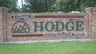
Hodge is a village in Jackson Parish, Louisiana, United States. The population was 470 at the 2010 census. It is part of the Ruston Micropolitan Statistical Area.

<span class="mw-page-title-main">Pleasant Hill, Sabine Parish, Louisiana</span> Village in Louisiana, United States

Pleasant Hill is a village in Sabine Parish in western Louisiana, United States. As of the 2010 census, the village population was 1,232. It is best known as the site of The Battle of Pleasant Hill, a Civil War engagement fought in April 1864.

<span class="mw-page-title-main">Tangipahoa, Louisiana</span> Village in Louisiana

Tangipahoa is a village in Tangipahoa Parish, Louisiana, United States. The population was 425 at the 2020 census. It was named after the Tangipahoa Native American tribe. Tangipahoa is part of the Hammond Micropolitan Statistical Area.

<span class="mw-page-title-main">Village Green, New York</span> Census-designated place in New York, United States

Village Green is a hamlet in Onondaga County, New York, United States. The population was 3,891 at the 2010 census.

<span class="mw-page-title-main">Central Square, New York</span> Village in New York, United States

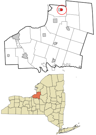
Central Square is a village in Oswego County, New York, United States. The population was 1,848 at the 2010 census.

<span class="mw-page-title-main">Lacona, New York</span> Village in New York, United States

Lacona is a village in Oswego County, New York, United States. The population was 582 at the 2010 census.

<span class="mw-page-title-main">Newtown, Ohio</span> Village in Ohio, United States

Newtown is a village in southeastern Hamilton County, Ohio, United States, near Cincinnati. The population was 2,702 at the 2020 census. Newtown was settled in 1792 and incorporated as a village in 1901.

<span class="mw-page-title-main">Graysville, Ohio</span> Village in Ohio, United States

Graysville is a village in Monroe County, Ohio, United States. The population was 70 at the 2020 census.

<span class="mw-page-title-main">Lewisville, Ohio</span> Village in Ohio, United States

Lewisville is a village in Monroe County, Ohio, United States. The population was 184 at the 2020 census.

<span class="mw-page-title-main">Frankfort, Ohio</span> Village in Ohio, United States

Frankfort is a village in Ross County, Ohio, United States, along the North Fork of Paint Creek. The village is located in Concord Township. The population was 1,064 at the 2010 census.

<span class="mw-page-title-main">Donaldson, Pennsylvania</span> CDP in Pennsylvania, United States

Donaldson is a census-designated place (CDP) in Frailey Township, Schuylkill County, Pennsylvania, United States. The population was 325 at the 2000 census.

<span class="mw-page-title-main">Hegins Township, Schuylkill County, Pennsylvania</span> Township in Pennsylvania, United States

Hegins Township is a township in Schuylkill County, Pennsylvania, United States. The population was 3,350 at the 2020 census.

<span class="mw-page-title-main">Bellwood, Virginia</span> CDP in Virginia, United States

Bellwood is a census-designated place (CDP) in Chesterfield County, Virginia, United States. The population was 6,352 at the 2010 census. The community takes its name from Bellwood, one of the James River Plantations.

<span class="mw-page-title-main">St. Cloud, Wisconsin</span> Village in Wisconsin, United States

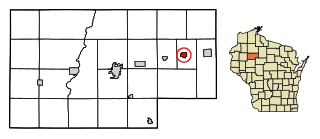
St. Cloud is a village in Fond du Lac County, Wisconsin, United States, along the Sheboygan River. The population was 477 at the 2010 census. St. Cloud is part of The Holyland region in northeastern Fond du Lac County.

<span class="mw-page-title-main">Ingram, Wisconsin</span> Village in Wisconsin, United States

Ingram is a village in Rusk County, Wisconsin, United States. The population was 78 at the 2010 census.

<span class="mw-page-title-main">Hannibal (village), New York</span> Village in New York, United States

Hannibal is a village in Oswego County, New York, United States. The population was 555 at the 2010 census. The village is named after Hannibal, the hero of ancient Carthage.

<span class="mw-page-title-main">Sandy Creek (village), New York</span> Village in New York, United States

Sandy Creek is a village in Oswego County, New York, United States. The population was 771 at the 2010 census.

References

  1. "ArcGIS REST Services Directory". United States Census Bureau. Retrieved September 20, 2022.
  2. "National Register Information System". National Register of Historic Places . National Park Service. March 13, 2009.
  3. "US Gazetteer files: 2010, 2000, and 1990". United States Census Bureau. February 12, 2011. Retrieved April 23, 2011.
  4. "Census of Population and Housing". Census.gov. Retrieved June 4, 2015.
  5. "U.S. Census website". United States Census Bureau . Retrieved January 31, 2008.