
Cotuit is one of the villages of the Town of Barnstable on Cape Cod in Barnstable County, Massachusetts, United States. Located on a peninsula on the south side of Barnstable about midway between Falmouth and Hyannis, Cotuit is bounded by the Santuit River to the west on the Mashpee town line, the villages of Marstons Mills to the north and Osterville to the east, and Nantucket Sound to the south. Cotuit is primarily residential with several small beaches including Ropes Beach, Riley's Beach, The Loop Beach and Oregon Beach.

Route 130 is a 11.90-mile-long (19.15 km) state highway in the U.S. state of Massachusetts. Its southern terminus is at Route 28 in Barnstable and the northern terminus is at Route 6A in Sandwich. Along the way it intersects U.S. Route 6 at exit 59 in Sandwich.

The National Register of Historic Places is a United States federal official list of places and sites considered worthy of preservation. In the state of Massachusetts, there are over 4,300 listings, representing about 5% of all NRHP listings nationwide and the second-most of any U.S. state, behind only New York. Listings appear in all 14 Massachusetts counties.

This is a list of the National Register of Historic Places listings in Barnstable County, Massachusetts.

The Provincetown Post Office is located at 217 Commercial Street in Provincetown, Massachusetts. It is located in a 2+1⁄2-story brick building that was built in 1930. The main facade has a loggia-style arcade of three arches on the first level, leading to a recessed entrance. The second story has three large windows across, and the gable end has an oculus window and dentil moulding. The building is crowned by a cupola.

The Adams-Crocker-Fish House is an historic house in Barnstable, Massachusetts. Built about 1830, this half-Cape is a rare surviving example of a small farmstead with period outbuildings. The property was listed on the National Register of Historic Places in 1987.

The Osterville Baptist Church is an historic Baptist church building at 824 Main Street in the Osterville village of Barnstable, Massachusetts. The white clapboarded wood-frame structure was built in 1837 for a congregation formed two years earlier. It is one of the older buildings in Osterville, and is a fine example of the Greek Revival with Gothic Revival elements. The church was listed on the National Register of Historic Places in 1987.

Emmett Cottage is a historic cottage in Brookline, Massachusetts, directly behind Saint Aidan's Church and Rectory. Of uncertain construction date but stylistically dated to the 1840s, it is a little-altered example of a small Gothic Revival cottage. It was listed on the National Register of Historic Places on October 17, 1985.

The Yarmouth Camp Ground Historic District is a historic district encompassing a religious summer camp meeting ground in Yarmouth and Barnstable, Massachusetts. The core of the camp ground was purchased in 1863 by the Sandwich District Camp Meeting Association, a Methodist Episcopal organization, and was operated until 1939. The area contains a well-preserved collection of predominantly residential buildings built during this period; it was listed on the National Register of Historic Places in 1990.

The Cotuit Historic District is a historic district encompassing the heart of the village of Cotuit in Barnstable, Massachusetts. It extends along Main Street from Lowell Street in the north to Sea Street in the south, and includes portions of Ocean View Avenue and properties on adjacent roads. The oldest properties date to the late 18th century, but saw its greatest development during the height of the area's maritime industry in the mid 19th century. In the late 19th and early 20th century the area saw new development as a summer resort area. The district was listed on the National Register of Historic Places in 1987.

The Craigville Historic District encompasses a historic religious camp meeting area in the Craigville section of Barnstable, Massachusetts, United States. It is centered on the junction of Lake Elizabeth Drive and Ocean Avenue, just west of Lake Elizabeth. The camp meeting was established in 1871 by the New England Convention of Christian Churches on land that was purchased from members of the Perry family. Along the grid of roads south of the main junction, gingerbread-decorated Gothic cottages were built over the following decades. The main tabernacle, an open-walled church, was built in 1887. The district was listed on the National Register of Historic Places in 1987.

The Nymphus Hinckley House is a historic house located in the Osterville village of Barnstable, Massachusetts.

The Marstons Mills Hearse House and Cemetery is a historic cemetery on Massachusetts Route 149 in the Marstons Mills section of Barnstable, Massachusetts. The hearse house, essentially a garage, was built c. 1885 to house a hearse for the village of Marstons Mills, and was one of seven such buildings erected in Barnstable. It is one of only two that are now left, and the only one that is relatively unaltered and in its original setting. It presently serves as a utility shed for the Marston Mills Cemetery, and is maintained by the local historic society. It is a simple rectangular wood-frame structure, with a gable roof, decorative shingle exterior, and a large double-leaf equipment door.

The Mill Way Historic District encompasses a residential area significant in the development of the maritime industry in Barnstable Village, Massachusetts. It includes thirteen houses, ten on Mill Way and three on adjacent Freezer Road, just north of the Old King's Highway. The district was listed on the National Register of Historic Places in 1987.

The Old King's Highway Historic District encompasses what was historically the principal east–west thoroughfare through Barnstable, Massachusetts. It encompasses Barnstable's entire length of what is now designated Massachusetts Route 6A and called Main Street, between the town lines of Sandwich and Yarmouth. It includes more than 1,000 acres (400 ha), and includes all of the buildings whose properties front on the road, nearly 500 in all. The area includes the main population centers of Barnstable from its founding in the late 1630s until the mid-19th century, when the southern parts of the community became more significant in economic prominence. The district was listed on the National Register of Historic Places in 1987.

The Pleasant–School Street Historic District is a predominantly residential historic district in the Hyannis village of Barnstable, Massachusetts. It includes 37 properties on Pleasant and School Streets, between Main and South Streets, near the center of Hyannis. Pleasant Street was laid out in the 18th century, and School Street was laid out c. 1850, and is distinctive for its cohesive collection of Greek Revival cottages, most of which were owned by mariners active in the coasting trade. The district was listed on the National Register of Historic Places in 1987.

The U.S. Customshouse is a historic customs house and United States Coast Guard museum on Cobbs Hill in Barnstable, Massachusetts. Built in 1855 to a design by Ammi Young, it was used as a custom house and post office until 1913, continuing to house the post office and other offices until 1958. It was converted into a museum in 1960, and was listed on the National Register of Historic Places in 1975.

The Santuit Historic District encompasses a cluster of historic houses around the junction of Falmouth Road and Main Street in the Santuit village of Barnstable, Massachusetts. It includes eight houses, six of which are historically significant for their association with the Crocker family, who were the first settlers of the area in the 18th century. The district was listed on the National Register of Historic Places in 1987.
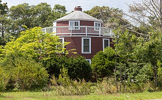
The Round House is a historic house located at 971 West Main Street in the Centerville village of Barnstable, Massachusetts.

Barnstable, Massachusetts, has more than 75 entries on the National Register of Historic Places. For listings elsewhere in Barnstable County, see National Register of Historic Places listings in Barnstable County, Massachusetts.


