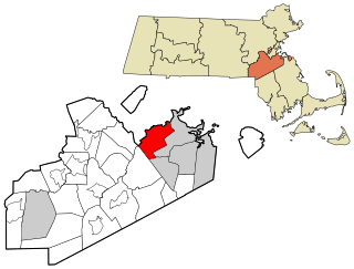
Milton is a town in Norfolk County, Massachusetts, United States and an affluent suburb of Boston. The population was 28,630 at the 2020 census.

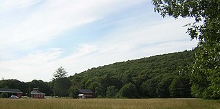
Blue Hills Reservation is a 7,000-acre (2,800 ha) state park in Norfolk County, Massachusetts in the United States. Managed by the Massachusetts Department of Conservation and Recreation, it covers parts of Milton, Quincy, Braintree, Canton, Randolph, and Dedham. Located approximately ten miles south of downtown Boston, the reservation is one of the largest parcels of undeveloped conservation land within the Greater Boston metropolitan area. The park's varied terrain and scenic views make it a popular destination for hikers from the Boston area.

The Sumner Hill Historic District encompasses a predominantly residential area of high-quality late 19th-century residences in the Jamaica Plain neighborhood of Boston, Massachusetts. It is roughly bounded by Seaverns Avenue, Everett Street, Carolina Avenue, and Newbern Street just east of the neighborhoods commercial Centre Street area. The district features Second Empire, Italianate, and Queen Anne style architecture, and was listed on the National Register of Historic Places in 1987.

The Avon Hill Historic District is a residential historic district near Porter Square in Cambridge, Massachusetts. Set atop Avon Hill southwest of Porter Square, this subdivision, laid out about 1870, contains a concentration of the finest Victorian and Second Empire residential buildings in the city. The district was listed on the National Register of Historic Places in 1983.
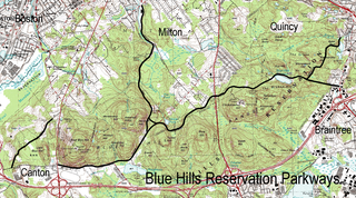
The Blue Hills Reservation Parkways are a network of historic parkways in and around the Blue Hills Reservation, a Massachusetts state park south of Boston, Massachusetts. It consists of six roadways that provide circulation within the park, and that join the park to two connecting parkways, the Blue Hills Parkway and the Furnace Brook Parkway. The roadway network was designed by Charles Eliot in the 1890s, except for Green Street, which was added to the network in the 1940s. The parkways were added to the National Register of Historic Places in 2003.

The Milton Hill Historic District is a historic district in Milton, Massachusetts. Extending mainly along Adams Street across the top of Milton Hill, it encompasses a residential area of high-style homes dating from the 18th to early 20th centuries. It was listed on the National Register of Historic Places in 1995.

The Abiah Bliss House is a historic house located at 154 Agricultural Avenue in Rehoboth, Massachusetts. With a claimed initial construction date of 1666, it is one of the oldest surviving buildings in the Rehoboth area.

The South Yarmouth/Bass River Historic District is a historic district in the southeastern part of Yarmouth, Massachusetts. It encompasses a predominantly residential area centered on a portion of Old Main Street and South Street between the villages of South Yarmouth and Bass River. The area's history is one of maritime-related industry from the late 18th to late 19th century, and then its growth as a tourist resort community. The district was listed on the National Register of Historic Places in 1990.

The Ware Millyard Historic District encompasses a 19th-century mill complex and industrial mill village in the town of Ware, Massachusetts. It is roughly bounded by South Street, the Ware River, Upper Dam Complex, Park Street, Otis Avenue and Church Street. The area includes surviving mill buildings, the oldest of which date to the 1840s, and a collection of tenement-style housing built for the millworkers, built between 1845 and the 1880s.

The Nobility Hill Historic District is a residential historic district roughly bounded by Chestnut and Maple Streets and Cedar Avenue in Stoneham, Massachusetts. The district includes a number of high quality houses representing a cross section of fashionable housing built between 1860 and 1920. It was added to the National Register of Historic Places in 1990.

Blue Hills Parkway is a historic parkway that runs in a straight line from a crossing of the Neponset River, at the south border of Boston to the north edge of the Blue Hills Reservation in Milton, Massachusetts. It was built in 1893 to a design by the noted landscape architect, Charles Eliot, who is perhaps best known for the esplanades along the Charles River. The parkway is a connecting road between the Blue Hills Reservation and the Neponset River Reservation, and was listed on the National Register of Historic Places in 2003.
Brookwood Farm is a historic farm on Blue Hill River Road in Canton, Massachusetts. Some of its fields, but none of the buildings, are in Milton. It is owned by the Commonwealth of Massachusetts and managed by the Department of Conservation and Recreation.

The Brush Hill Historic District is a residential historic district along Brush Hill Road in Milton, Massachusetts. First developed in the 1660s, the district now encompasses a diversity of rural-suburban residential architecture from the late-17th to mid-29th centuries, encapsulating the development of the town's predominantly residential character. The district was listed on the National Register of Historic Places in 1998.

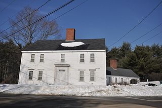
Gov. Thomas Hutchinson's Ha-ha is a historic ha-ha at 100–122 Randolph Avenue in Milton, Massachusetts, United States. Probably built about 1771, it is the only surviving structure of the once-extensive estate of Thomas Hutchinson, the last civilian colonial governor of the British Province of Massachusetts Bay, and one of the few examples of an early ha-ha in North America. It was added to the National Register of Historic Places in 1975, and is a contributing property to the Milton Hill Historic District.

The Milton Centre Historic District encompasses the traditional civic heart of Milton, Massachusetts. The district is located on Canton Avenue between Readsdale Road and Thacher and Highland Streets, and includes municipal buildings, churches, and residences, most built in the 18th or 19th century. The district was listed on the National Register of Historic Places in 1988.

The Refreshment Pavilion is a historic refreshment stand at Houghton's Pond in the Milton portion of Blue Hills Reservation, a Massachusetts state park. Built in 1920, it is one of a series of architect-designed structures built in the park by the Metropolitan District Commission. It was listed on the National Register of Historic Places in 1980.
The Captain Jonathan Currier House is a historic house on Hillside Avenue in South Hampton, New Hampshire. Built about 1742, it is the oldest surviving house in Currierville, one of the early settlement areas in South Hampton. It was listed on the National Register of Historic Places in 1983.

The Town Center Historic District encompasses the historic village center of South Hampton, New Hampshire. Centered around the Barnard Green, the town common, on New Hampshire Route 107A, it includes architectural reminders of the town's growth and change over time. The district was listed on the National Register of Historic Places in 1983.

The Eustis Estate is a historic family estate on Canton Avenue in Milton, Massachusetts. Its centerpiece is the mansion house of William Ellery Channing Eustis, an eclectic Late Victorian stone building designed by preeminent architect William Ralph Emerson and constructed in 1878. The estate also includes several other houses associated with the Eustis family, and a gatehouse and stable historically associated with the main estate. The estate was listed on the National Register of Historic Places as a historic district in 2016. Most of the original estate is owned by Historic New England, and was opened to the public as a museum property in 2017.

The Rocky Hill Center Historic District encompasses the traditional town center and surrounding residential area of Rocky Hill, Connecticut. It extends along Old Main Street from the Wethersfield line southward to a triangular area bounded by Old Main, Riverview Road, and Glastonbury Avenue. Included in a basically 19th-century streetscape are the town's principal civic and religious buildings, as well as a fine collection of mainly 18th and 19th-century residential architecture. The district was listed on the National Register of Historic Places in 2007.


