
In geography, latitude is a geographic coordinate that specifies the north–south position of a point on the Earth's surface. Latitude is an angle which ranges from 0° at the Equator to 90° at the poles. Lines of constant latitude, or parallels, run east–west as circles parallel to the equator. Latitude is used together with longitude to specify the precise location of features on the surface of the Earth. On its own, the term latitude should be taken to be the geodetic latitude as defined below. Briefly, geodetic latitude at a point is the angle formed by the vector perpendicular to the ellipsoidal surface from that point, and the equatorial plane. Also defined are six auxiliary latitudes that are used in special applications.
Longitude, is a geographic coordinate that specifies the east–west position of a point on the Earth's surface, or the surface of a celestial body. It is an angular measurement, usually expressed in degrees and denoted by the Greek letter lambda (λ). Meridians connect points with the same longitude. The prime meridian, which passes near the Royal Observatory, Greenwich, England, is defined as 0° longitude by convention. Positive longitudes are east of the prime meridian, and negative ones are west.

A geographic coordinate system (GCS) is a coordinate system associated with positions on Earth. A GCS can give positions:

The ecliptic coordinate system is a celestial coordinate system commonly used for representing the apparent positions and orbits of Solar System objects. Because most planets and many small Solar System bodies have orbits with only slight inclinations to the ecliptic, using it as the fundamental plane is convenient. The system's origin can be the center of either the Sun or Earth, its primary direction is towards the vernal (March) equinox, and it has a right-hand convention. It may be implemented in spherical or rectangular coordinates.

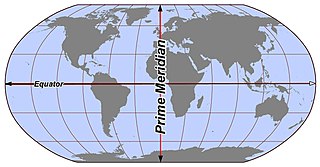
A prime meridian is the meridian in a geographic coordinate system at which longitude is defined to be 0°. Together, a prime meridian and its anti-meridian form a great circle. This great circle divides a spheroid into two hemispheres. If one uses directions of East and West from a defined prime meridian, then they can be called the Eastern Hemisphere and the Western Hemisphere.
A terminator or twilight zone is a moving line that divides the daylit side and the dark night side of a planetary body. A terminator is defined as the locus of points on a planet or moon where the line through the center of its parent star is tangent. An observer on the terminator of such an orbiting body with an atmosphere would experience twilight due to light scattering by particles in the gaseous layer.
Luna 18, part of the Ye-8-5 series, was an unmanned space mission of the Luna program.

A circle of latitude on Earth is an abstract east–west circle connecting all locations around Earth at a given latitude.

The geography of Mars, also known as areography, entails the delineation and characterization of regions on Mars. Martian geography is mainly focused on what is called physical geography on Earth; that is the distribution of physical features across Mars and their cartographic representations.
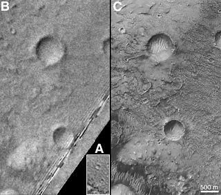
Airy-0 is a crater on Mars whose location defines the position of the prime meridian of that planet. It is about 0.5 kilometres (0.31 mi) across and lies within the larger crater Airy in the region Sinus Meridiani. The IAU Working Group on Cartographic Coordinates and Rotational Elements has now recommended setting the longitude of the Viking 1 lander as the standard. This definition maintains the position of the center of Airy-0 at 0° longitude, within the tolerance of current cartographic uncertainties.

In geodesy, a reference ellipsoid is a mathematically defined surface that approximates the geoid, which is the truer, imperfect figure of the Earth, or other planetary body, as opposed to a perfect, smooth, and unaltered sphere, which factors in the undulations of the bodies' gravity due to variations in the composition and density of the interior, as well as the subsequent flattening caused by the centrifugal force from the rotation of these massive objects . Because of their relative simplicity, reference ellipsoids are used as a preferred surface on which geodetic network computations are performed and point coordinates such as latitude, longitude, and elevation are defined.
A (geographic) meridian is the half of an imaginary great circle on the Earth's surface, terminated by the North Pole and the South Pole, connecting points of equal longitude, as measured in angular degrees east or west of the Prime Meridian. The position of a point along the meridian is given by that longitude and its latitude, measured in angular degrees north or south of the Equator. Each meridian is perpendicular to all circles of latitude. Meridians are half of a great circle on the Earth's surface. The length of a meridian on a modern ellipsoid model of the earth has been estimated at 20,003.93 km.
ISO 6709, Standard representation of geographic point location by coordinates, is the international standard for representation of latitude, longitude and altitude for geographic point locations.

Aratus is a small lunar impact crater located on the highland to the south and east of the rugged Montes Apenninus range. It is a circular, cup-shaped crater with a relatively high albedo. It was named after Greek astronomer Aratus of Soli. To the east is the Mare Serenitatis, and to the southwest is the somewhat larger crater Conon. North-northeast of Aratus is the landing site of the Apollo 15 mission, just beyond Mons Hadley Delta.
Mösting is a small lunar impact crater that is located in the southeastern fringes of the Mare Insularum. It was named after Danish benefactor Johan Sigismund von Mösting. The ruined crater Sömmering lies to the northwest. To the southeast is the large crater-bay of Flammarion. Mösting has a terraced inner wall and a small central hill at the midpoint of the floor.

Sinus Medii is a small lunar mare. It takes its name from its location at the intersection of the Moon's equator and prime meridian; as seen from the Earth, this feature is located in the central part of the Moon's near side, and it is the point closest to the Earth. From this spot the Earth would always appear directly overhead, although the planet's position would vary slightly due to libration.

Mons Gruithuisen Gamma (γ) is a lunar dome that lies to the north of the crater Gruithuisen at the western edge of the Mare Imbrium. It is located at selenographic coordinates 36.6° N, 40.5° W.
A lunar standstill is the gradually varying range between the northern and the southern limits of the Moon's declination, or the lunistices, over the course of one-half a sidereal month, or 13.66 days. One major, or one minor, lunar standstill occurs every 18.6 years due to the precessional cycle of the lunar nodes at that rate.

The near side of the Moon is the lunar hemisphere that is permanently turned towards Earth, as opposed to the opposite far side. Only one side of the Moon is visible from Earth because the Moon rotates on its axis at the same rate that the Moon orbits the Earth – a situation known as synchronous rotation, or tidal locking.
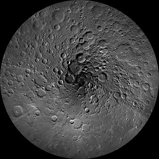
The lunar north pole is the point in the Northern Hemisphere of the Moon where the lunar axis of rotation meets its surface.

