Setiu Wetlands

Last updated

Setiu Wetlands State Park
Malay: Taman Negeri Setiu Wetlands
Jawi: تامن نݢري ستيو ويتلندس
The boardwalk of Setiu Wetlands State Park.jpg
The boardwalk of Setiu Wetlands that allows visitors to walk throughout the area.
Terengganu location map.svg
Red pog.svg
Setiu Wetlands State Park
Malaysia relief location map.jpg
Red pog.svg
Setiu Wetlands State Park
Location Setiu, Terengganu, Malaysia
Coordinates 5°40′20″N102°43′04″E / 5.67222°N 102.71778°E / 5.67222; 102.71778
Type Freshwater, seawater, and brackish water
Primary inflows Setiu River
Basin  countries Malaysia
Managing agencyTerengganu State Park Management Council
Designation State park
Max. length14 km (8.7 mi) (lagoon)
Surface area23,000 hectares (57,000 acres)

Setiu Wetlands (Malay: Tanah Bencah Setiu or Laguna Setiu) is a wetland in Setiu District, Terengganu, Malaysia. It is part of the Setiu River basin, and also of the larger Setiu-Chalok-Bari-Merang basin wetland complex. Spread over 23,000 hectares, Setiu Wetlands is the largest natural wetlands in the East Coast region of Peninsular Malaysia, combining various ecosystems including freshwater, seawater, brackish water and a 14 km lagoon. [1]

Contents

Access

It is less than an hour drive from Kuala Terengganu, the capital of Terengganu. The nearest towns to the wetlands are Penarik and Bandar Permaisuri. Setiu Wetlands is accessed via Pengkalan Gelap. [2]

Hydrology and ecosystem

Approximately 75 per cent of Setiu district is wetland areas, which mainly consists Chalok River basin, Bari River basin, and Merang River basin that converge and form a continuous lagoon. [3] These areas start from the coastal lowland plains of the South China Sea in the east to the hilly areas in western Setiu, that includes Mount Tebu. Setiu Wetlands itself is 26 kilometres long and 1.5 kilometres at its widest section. [4]

Setiu Wetlands is a mixture of riverbank riparian forest, peat swamp, mangroves, brackish lagoons with vegetation and sand islands, seagrass beds and sandy beaches. It is also unique for having a diverse array of interconnected ecosystems, namely the sea, beach, mudflat, lagoon, estuary, river, islands, coastal forest and mangrove forest. [5]

Flora and fauna

The lowland areas forming the Setiu Wetlands contain a large swath of Melaleuca or Gelam trees (also known as paperbark tea-tree) that is rare in this country. [6] [7] The river basin also contains other kinds of coastal swamp and freshwater swamp forest such as nipa palms forest, Bruguiera forest, mixed mangrove forest, Lumnitzera forest, Rhizophora forest, Melaleuca forest, and Avicennia forest. Another feature of Setiu Wetlands is the presence of seagrass beds. [4]

The fruit of nipa palm (Nypa fruticans), a mangrove plant species found in abundance at the park. Nipa palm (Nypa fruticans) fruit, Setiu Wetlands State Park.jpg
The fruit of nipa palm ( Nypa fruticans ), a mangrove plant species found in abundance at the park.

The Wetlands is an area of high biodiversity and very hard to find. From a number of research carried out, 29 species of mammals, 161 species of birds, and 36 species of reptiles and amphibias are found. [8] The Wetlands is also home to some endangered species such as river terrapin (Batagur affinis), Painted terrapin (Batagur borneoensis), and Green sea turtle (Chelonia mydas). [3] [9] Besides that, marine animals that includes various invertebrate species (annelid, nematodes and polychaetes), gastropoda species, and bivalvia species (clams, oysters, and mussels as examples), crustaceans are also available. About 37 fish species are discovered in this area, 18 being freshwater species while the rest are saltwater fish species that enter the Wetlands to reproduce. [4]

The Setiu Wetlands is also the only other location where a large colony of the Papilionanthe hookeriana, which is an orchid species, can be found. It is also known as Kinta weed and, as the name suggests, its other habitat is in the swamps of the Kinta Valley in Perak. This orchid species is protected in the state. [10] Scientists from the Malaysian Agricultural Research and Development Institute (MARDI) have also discovered a new variety of the nepenthes rafflesiana, a type of pitcher plant in the wetlands. [11]

Culture

Setiu Wetlands is a major aquaculture spot. The local residents are involved in brackish water cage culture, pond culture, pen culture and oyster farming. It is a large producer of grouper and oyster seeds. Other than that, the lagoon is also a natural harbour for fishing boats of the fishermen surrounding the area. Local industries at the local villages such as the production of seafood-based delicacies such as budu (fermented fish sauce), fish crackers, dried anchovies and belacan (shrimp paste). Small fishing boat-making industry is also carried out by the villagers. [4] The locals also make handicrafts from kercut and nipah, long-stemmed grass that grows wild in swampy areas. [2]

A species of mangrove crab and snail (Cerithidea sp.) that make the mangrove area their habitat. Mangrove crab and snail, Setiu Wetlands State Park.jpg
A species of mangrove crab and snail ( Cerithidea sp.) that make the mangrove area their habitat.

Setiu Wetlands State Park

The Government of Terengganu stated that the park would be gazetted as the first State Park in Terengganu in 2015 (although Terengganu has a national park within its boundary, and a few marine parks). The decision to create the State Park came due to biological diversity of the area, the protection of the natural environment, and the potentials for ecotourism. [12] The early phase of the park involved an area the size of 400 hectares. [13] On 10 May 2018, the Terengganu State Government officially declared Setiu Wetlands as the first state park in Terengganu, which was named as Setiu Wetlands State Park. [14]

See also

Related Research Articles

<span class="mw-page-title-main">Caroni Swamp</span> Largest mangrove wetland in Trinidad and Tobago

The Caroni Swamp is the largest mangrove wetland in Trinidad and Tobago. It is located on the west coast of Trinidad, south of Port of Spain and northwest of Chaguanas, where the Caroni River meets the Gulf of Paria.

<span class="mw-page-title-main">Orinoco Delta</span> Delta region of the Orinoco River

The Orinoco Delta is a vast river delta of the Orinoco River, located in eastern Venezuela.

<span class="mw-page-title-main">Setiu District</span> District of Malaysia in Terengganu

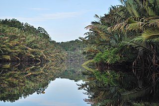
Setiu is one of the districts in Terengganu, Malaysia. This district is bordered by Besut to the north, Hulu Terengganu to the south, and on the east, Kuala Nerus District.

<span class="mw-page-title-main">Wildlife of Liberia</span> Wildlife inhabiting of Liberia

The wildlife of Liberia consists of the flora and fauna of the Republic of Liberia. This West African nation has a long Atlantic coastline and a range of habitat types, with a corresponding diversity of plants and animals. Liberia is considered a biodiversity hotspot and has more intact forests characteristic of the Upper Guinea Massif than do neighbouring countries. There are 2000 species of vascular plants, approximately 140 species of mammals, and over 600 species of birds.

<span class="mw-page-title-main">Wildlife of the Gambia</span> Flora and fauna of the Gambia

The wildlife of the Gambia is dictated by several habitat zones over the Gambia's land area of about 10,000 km2. It is bound in the south by the savanna and on the north by the Sudanian woodlands. The habitats host abundant indigenous plants and animals, in addition to migrant species and newly planted species. They vary widely and consist of the marine system, coastal zone, estuary with mangrove vegetation coupled with Banto Faros, river banks with brackish and fresh water zones, swamps covered with forests and many wetlands.

Niumi National Park is a national park in The Gambia. The occupies the coastal strip in the northern region of the country, in the southern tip of the Sine-Saloum Delta. It covers an area of approximately 4,940 ha and encompasses a range of types of wetlands and vegetation, from freshwater marsh to sand spits and brackish lagoons. Rhizophora mangrove forest is abundant in the park, and its swamp and mudflats are an important sheltering ground for birds, with over 200 species found here.

Classification of wetlands has been a problematical task, with the commonly accepted definition of what constitutes a wetland being among the major difficulties. A number of national wetland classifications exist. In the 1970s, the Ramsar Convention on Wetlands of International Importance introduced a first attempt to establish an internationally acceptable wetland classification scheme.

<span class="mw-page-title-main">Berbak National Park</span>

The Berbak National Park in Sumatra island, Jambi province of Indonesia, forms part of the largest undisturbed swamp forest in southeastern Asia, and the peat swamp forest with the greatest number of palm species. Protected since 1935 under Dutch colonial law and later declared a national park, it has been also recognised as a wetland of international importance.

<span class="mw-page-title-main">Southern river terrapin</span> Species of turtle

The southern river terrapin is a riverine turtle of the family Geoemydidae found in Malaysia, Indonesia and Cambodia.

Sarstoon-Temash is the southernmost national park in Belize. The national park was designated in 1994, and covers an area of 165.92 km2. It is managed by the Sarstoon Temash Institute for Indigenous Management (SATIIM), in partnership with the Forest Department.

Tourism in Terengganu deals with attractions, events and facilities in Terengganu, Malaysia of special interest to tourists.

<span class="mw-page-title-main">Guianan mangroves</span> Coastal ecoregion of southeastern Venezuela, Guyana, Suriname and French Guiana

The Guianan mangroves (NT1411) is a coastal ecoregion of southeastern Venezuela, Guyana, Suriname, French Guiana and Brazil. The mangroves provide an important habitat for migrating birds that winter in the area. Large areas are intact, although they are threatened by destruction of the trees for timber and to make way for agriculture, and from upstream agricultural and industrial pollution.

<span class="mw-page-title-main">Orinoco Delta swamp forests</span> Wetland region of Venezuela and Guyana

The Orinoco Delta swamp forests (NT0147) is an ecoregion of eastern Venezuela and northern Guyana covering the large and shifting Orinoco Delta. The vegetation is mostly permanently flooded rainforest. The ecoregion is relatively intact apart from a large area that was damaged by a failed flood control program in the 1960s. It is inaccessible, so logging is difficult, and the soil is unsuitable for farming. The main threat comes from oil exploration, which would bring an influx of settlers into the delta.

<span class="mw-page-title-main">Orinoco wetlands</span> Ecoregion in northeast Venezuela

The Orinoco wetlands (NT0906) is an ecoregion of northeast Venezuela within the northern Orinoco Delta. It holds areas of tall grasses in flooded land, surrounded by mangroves and swamp forest, giving way to the drier Llanos savanna in the west.

<span class="mw-page-title-main">Tonle Sap–Mekong peat swamp forests</span> Ecoregion in Cambodia and southern Vietnam

The Tonle Sap-Mekong peat swamp forests ecoregion covers a patchwork of areas permanently inundated with fresh water along the Tonle Sap River and Mekong River floodplains in Cambodia and Vietnam. The terrain is mostly flat, with extensive agricultural fields, reed beds, and degraded shrub forest. Less than 10% of the region is in its original state, and less than 1% is protected. Habitat in the region is distinguished from the Tonle Sap freshwater swamp forests ecoregion that runs through the middle, as that ecoregion is only seasonally flooded.

<span class="mw-page-title-main">Trinidad mangroves</span> Ecoregion in Trinidad

The Trinidad mangroves ecoregion covers the separate mangrove forest areas on the coast of the island of Trinidad, in the country of Trinidad and Tobago. The character of the mangroves is affected by the large amount of fresh water flowing out of the Orinoco River and Amazon River to the south, which flow northwest around the island. The mangroves of Trinidad are found on all coasts, and are usually in the estuaries of rivers, but also found in coastal lagoons.

<span class="mw-page-title-main">Usumacinta mangroves</span>

The Usumacinta mangroves ecoregion covers the mangrove forests ont the Gulf Coast of Mexico, around the margins of the Laguna de Términos. The "Ends" in the name refer to the mouths of the rivers that empty into the lagoon, including the Usumacinta River. This region, which is due south of the mouth of the Mississippi River across the Gulf of Mexico, receives an estimated one-third of the wintering birds migrating on the Mississippi Flyway. It is estimated that the lagoon supports 90 endangered species.

<span class="mw-page-title-main">Alvarado mangroves</span> Mangroves ecoregion of Tamaulipas and Veracruz, Mexico

The Alvarado mangroves ecoregion covers a series of mangrove forest areas along the Gulf of Mexico coast of the states of Tamaulipas and Veracruz in Mexico. they are the most northerly mangroves in the western Gulf. The largest tracts of mangrove swamps occur at the mouths of rivers, and nearby coastal lagoon.

Sri Lanka exhibits a remarkable biological diversity and is considered to be the richest country in Asia in terms of species concentration.

The Alvarado Lagoon System is a large estuary and wetland complex in Veracruz state of eastern Mexico. It is located on the southern Gulf Coastal Plain, where the Papaloapan and Blanco rivers meet the Gulf of Mexico.

References

  1. "Setiu Wetlands in Terengganu to become first state park | Travel". Malay Mail Online. 2015-03-25. Retrieved 2015-04-23.
  2. 1 2 Wong, Alexandra (December 18, 2019). "Setiu Wetlands: Terengganu's hidden eco-gem". Going Places by Malaysia Airlines.
  3. 1 2 "Public awareness of Setiu Wetlands important: WWF Malaysia | theSundaily". Thesundaily.my. Retrieved 2015-04-23.
  4. 1 2 3 4 "Tanah Bencah Setiu". Utusan Malaysia. 4 February 2013.
  5. "Setiu Wetlands on the road to becoming state park - Nation | The Star Online". Thestar.com.my. 2013-06-12. Retrieved 2015-04-23.
  6. "Setiu Wetland akan dijadikan Taman Negeri - Terengganu". Sinar Harian. 2015-03-26. Retrieved 2015-04-23.
  7. "Terengganu to propose gazetting of Setiu Wetlands as state park - Nation | The Star Online". Thestar.com.my. Retrieved 2015-04-23.
  8. "Berita Wilayah". Bernama.com. 2015-03-26. Retrieved 2015-04-23.
  9. "WWF Malaysia - Setiu Wetlands: A Perfect Choice to be Terengganu's First State Park". Wwf.org.my. 2013-06-10. Retrieved 2015-04-23.
  10. "Make Setiu Wetlands a premier tourist destination | New Straits Times".
  11. "Mardi discovers new variety of pitcher plant | New Straits Times".
  12. Adnan Mohamad (2015-04-16). "Tanah Bencah Setiu diselamatkan - Terengganu - Utusan Online". Utusan.com.my. Retrieved 2015-04-23.
  13. "Setiu Wetland diwarta ekopelancongan negeri - Wilayah - Utusan Online". Utusan.com.my. 2015-04-16. Retrieved 2015-04-23.
  14. KAMARUDDIN, KAMALIZA (September 22, 2023). "Sasar 30,000 pengunjung hadir Festival Setiu Wetlands".