Sharkfin Tower

Last updated
Sharkfin Tower
Sharkfin Tower from southwest.jpg
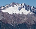
Sharkfin Tower, south aspect
Highest point
Elevation 8,120 ft (2,470 m) [1]
Prominence 80 ft (24 m) [2]
Parent peak Boston Peak (8894 ft) [2]
Coordinates 48°29′59″N121°02′23″W / 48.499621°N 121.039826°W / 48.499621; -121.039826 [3]
Geography
USA Washington relief location map.jpg
Red triangle with thick white border.svg
Sharkfin Tower
Location in Washington
Usa edcp relief location map.png
Red triangle with thick white border.svg
Sharkfin Tower
Sharkfin Tower (the United States)
Location
Parent range North Cascades
Cascade Range
Topo map USGS Cascade Pass
Geology
Type of rock Granite, Orthogneiss
Climbing
First ascent 1947 by Wesley Grande, Jay Todd, Joseph Vance
Easiest route SE Ridge Climbing class 5.0

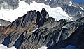
Sharkfin Tower is an 8,120+ ft (2,470+ m) summit located in North Cascades National Park, in Skagit County of Washington state. It is set in the scenic North Cascades, which is a sub-range of the Cascade Range. The peak is situated midway on the high ridge which connects Forbidden Peak with Boston Peak. The Quien Sabe Glacier lies below its southern cliffs, and the immense Boston Glacier spreads out below the north aspect. Surface runoff from Sharkfin Tower drains into the Cascade River and Thunder Creek, both of which are tributaries of the Skagit River.

Contents

Climbing

Many climbers consider Sharkfin Tower as having some of the best granite in the state of Washington. [4] Two popular established rock climbing routes are the Southeast Ridge (YDS 5) first climbed in August 1947, and the Southeast Face (YDS 5.10), first climbed by Jim Nelson, Jim Martin, Kit Lewis, Bill Liddell, and Dave Bale in September 1990. [5] The first ascent of the Northwest Face was made on July 1, 1968, by Mike Heath, Dan Raish, and Woody Savage. [6] On July 10, 2005, tragedy befell a party of The Mountaineers attempting to climb the tower, resulting in three fatalities and one injured.

Climate

Sharkfin Tower, Boston Peak, and Sahale Peak surround the Quien Sabe Glacier in this view from Hidden Lake Peaks Boston Sahale Quien Sabe.jpg
Sharkfin Tower, Boston Peak, and Sahale Peak surround the Quien Sabe Glacier in this view from Hidden Lake Peaks

Sharkfin Tower is located in the marine west coast climate zone of western North America. [1] Most weather fronts originate in the Pacific Ocean, and travel northeast toward the Cascade Mountains. As fronts approach the North Cascades, they are forced upward by the peaks of the Cascade Range, causing them to drop their moisture in the form of rain or snowfall onto the Cascades (Orographic lift). As a result, the west side of the North Cascades experiences high precipitation, especially during the winter months in the form of snowfall. During winter months, weather is usually cloudy, but, due to high pressure systems over the Pacific Ocean that intensify during summer months, there is often little or no cloud cover during the summer. [1] Because of maritime influence, snow tends to be wet and heavy, resulting in high avalanche danger.

Geology

The North Cascades features some of the most rugged topography in the Cascade Range with craggy peaks and ridges, and deep glacial valleys. Geological events occurring many years ago created the diverse topography and drastic elevation changes over the Cascade Range leading to various climate differences.

Sharkfin Tower from southeast Sharkfin Tower from southeast.jpg
Sharkfin Tower from southeast

The history of the formation of the Cascade Mountains dates back millions of years ago to the late Eocene Epoch. [7] With the North American Plate overriding the Pacific Plate, episodes of volcanic igneous activity persisted. [7] In addition, small fragments of the oceanic and continental lithosphere called terranes created the North Cascades about 50 million years ago. [7]

During the Pleistocene period dating back over two million years ago, glaciation advancing and retreating repeatedly scoured the landscape leaving deposits of rock debris. [7] The U-shaped cross section of the river valleys is a result of recent glaciation. Uplift and faulting in combination with glaciation have been the dominant processes which have created the tall peaks and deep valleys of the North Cascades area.

See also

Related Research Articles

<span class="mw-page-title-main">Mount Redoubt (Washington)</span> Mountain in Washington (state), United States

Mount Redoubt is a mountain in the North Cascades range in Whatcom County, Washington state. The peak is located 3.0 miles (5 km) from the Canada–US border, 16.3 miles (26 km) east-northeast of Mount Shuksan. It is the 21st highest peak in the state, with a height of 8,956 feet (2,730 m) and a prominence of 1,649 feet (503 m). Redoubt is in the Skagit Range, a sub-range of the North Cascades, in the Custer-Chilliwack Group which includes Mount Spickard, Mount Redoubt, Mount Custer and Mox Peaks, among others. Redoubt, Bear, and Depot creeks drain off the mountain, which is composed of Skagit gneiss. Mount Redoubt is listed as one of the "Classic Eight Peaks" in the North Cascades.

<span class="mw-page-title-main">Forbidden Peak</span> Mountain in Washington, United States

Forbidden Peak is an 8,815 feet (2,687 m) glacial horn located in North Cascades National Park, in Skagit County of Washington state. It is part of the North Cascades and is located near Cascade Pass. Forbidden Peak features a rock climbing route named West Ridge route which is featured in Fifty Classic Climbs of North America. The peak was first climbed by a party consisting of Fred Beckey, his brother Helmy Beckey, Jim Crooks, Lloyd Anderson and Dave Lind in 1940.

<span class="mw-page-title-main">Tower Mountain (Washington)</span> Mountain in Washington (state), United States

Tower Mountain is a prominent non-volcanic mountain located on the boundary line of Okanogan and Skagit counties in Washington state. It is part of the Okanogan Range which is a sub-range of the North Cascades Range. Tower Mountain situated on land administered by the Okanogan–Wenatchee National Forest.

<span class="mw-page-title-main">Paul Bunyans Stump</span> Mountain in Washington (state), United States

Paul Bunyans Stump is a 7,480+ ft mountain summit in the North Cascades Range of Washington, United States. It is located within North Cascades National Park. It rises steeply from Diablo Lake, one of the reservoirs on the Skagit River. It is part of a group of peaks that form the northern end of a chain running south through climbing destinations such as Colonial Peak and Snowfield Peak. The nearest peak to Paul Bunyans Stump is Pinnacle Peak, 0.37 mi (0.60 km) to the north, and the nearest higher peak is Neve Peak, 0.9 mi (1.4 km) to the southeast. Like many North Cascade peaks, Paul Bunyans Stump is more notable for its large, steep rise above local terrain than for its absolute elevation. Precipitation runoff from the mountain drains into Diablo Lake and Skagit River.

<span class="mw-page-title-main">Azurite Peak</span> Mountain in Washington (state), United States

Azurite Peak is an 8,400-foot (2,600-metre) double-summit mountain located at the common boundary point of Okanogan County, Skagit County, and Whatcom County in Washington state. It is part of the Okanogan Range which is a sub-range of the North Cascades Range. Azurite Peak is situated north of Azurite Pass on land administered by the Okanogan–Wenatchee National Forest. The nearest higher neighbor is Tower Mountain, 5.24 miles (8.43 km) to the south-southeast, and Mount Ballard lies 1.97 miles (3.17 km) to the north. Remnants of a small pocket glacier are found on the east aspect. The Pacific Crest Trail traverses the base of Azurite Peak.

<span class="mw-page-title-main">Mix-up Peak</span> Mountain in Washington (state), United States

Mix-up Peak, also known as Mixup Peak, is a 7,440-foot (2,270-metre) mountain summit located on the shared boundary of Skagit County and Chelan County in Washington state. It is part of the North Cascades Range and is situated one mile south of Cascade Pass on the shared border of North Cascades National Park and Glacier Peak Wilderness. The nearest higher peak is Magic Mountain, 1.02 miles (1.64 km) to the east-southeast. Mix-up Peak is at the northern end of the Ptarmigan Traverse which is an alpine route to remote mountains such as Mount Formidable and Dome Peak. The Cache Glacier occupies a cirque below its eastern flank. Surface runoff on the east side the mountain drains into the Stehekin River, whereas precipitation runoff drains into the Cascade River from the west side.

<span class="mw-page-title-main">Blackbeard Peak</span> Mountain in Washington (state), United States

Blackbeard Peak, also spelled Black Beard Peak, is a 7,241-foot mountain summit in the North Cascades in the U.S. state of Washington. It is located in the Okanogan–Wenatchee National Forest in Skagit County. It is situated northwest of Rainy Pass, southwest of Porcupine Peak, and southeast of Graybeard Peak. Its nearest higher neighbor is Repulse Peak, 1.06 mi (1.71 km) to the west. Blackbeard Peak can be seen from the North Cascades Highway. Precipitation runoff from Blackbeard Peak drains into Granite Creek, a tributary of the Skagit River.

<span class="mw-page-title-main">Round Mountain (Washington)</span> Mountain in Washington (state), United States

Round Mountain is a 5,320+ ft mountain summit at the western edge of the North Cascades, in Skagit County of Washington state. It is located nine miles northwest of Darrington, Washington and is situated on land administered by the Mount Baker-Snoqualmie National Forest. Round Mountain is remarkable for its 4,780 feet of prominence which ranks as the most in Skagit County, and eighth most of all the mountains in Washington state. The nearest higher peak is Whitehorse Mountain, 7.85 miles (12.63 km) to the south-southeast. Precipitation runoff from Round Mountain drains into tributaries of the Stillaguamish River.

<span class="mw-page-title-main">Mount Misch</span> Mountain in Washington (state), United States

Mount Misch is a remote 7,435 ft mountain summit in the North Cascades, in Skagit County of Washington state. It is the highest point of the Buckindy Range, or Buckindy Ridge. It is located 19 miles east-northeast of Darrington, Washington, and 15 miles north-northwest of Glacier Peak which is one of the Cascade stratovolcanoes. It is situated in the Glacier Peak Wilderness on land administered by the Mount Baker-Snoqualmie National Forest. Mount Misch was named by mountaineer and author Fred Beckey for his friend Peter Misch (1909-1987), University of Washington geology professor and mountaineer, who was renowned for his study of the North Cascades. Precipitation runoff from Mount Misch and the unnamed Goat Creek glacier on its east slope drains into tributaries of the Suiattle River and ultimately the Skagit River.

<span class="mw-page-title-main">Mount Chaval</span> Mountain in Washington (state), United States

Mount Chaval is a craggy 7,127-foot (2,172-metre) mountain summit located in Skagit County of Washington state. Situated within the Glacier Peak Wilderness, Mount Chaval is positioned west of the crest of the North Cascades Range, approximately 15 miles northeast of the town of Darrington. It has two subsidiary peaks, East Peak and Middle Peak, each 7040 ft. Its nearest higher neighbor is Snowking Mountain, 2.51 miles (4.04 km) to the northeast. Precipitation runoff from Mount Chaval drains into tributaries of the Skagit River.

<span class="mw-page-title-main">Snowking Mountain</span> Mountain in Washington (state), United States

Snowking Mountain is a 7,433-foot (2,266-metre) summit located in Skagit County of Washington state. Situated within the Glacier Peak Wilderness, Snowking Mountain is positioned west of the crest of the North Cascades Range, approximately 18 miles northeast of the town of Darrington. It is set within the Glacier Peak Wilderness, on land managed by Mount Baker–Snoqualmie National Forest. Snowking has two subsidiary peaks, West Peak (7425 ft), and Middle Peak (7400 ft). A broad unnamed glacier known colloquially as Snowking Glacier rests on the north face. Downslope of that glacier are Snowking Lake, Found Lake, and Cyclone Lake. Mount Tommy Thompson is three miles to the northwest, and the nearest higher neighbor is Mount Misch, 5.75 miles (9.25 km) to the southeast. Precipitation runoff from Snowking Mountain drains into tributaries of the Skagit River.

<span class="mw-page-title-main">Cascade Peak</span>

Cascade Peak is a 7,428-foot (2,264-metre) mountain summit located in Skagit County of Washington state. It is in the North Cascades, which is a subrange of the Cascade Range. The peak is situated above Cascade Pass, on the shared border of North Cascades National Park and Glacier Peak Wilderness. The nearest higher peak is Johannesburg Mountain, 0.53 miles (0.85 km) to the west-southwest, and The Triplets stand guard 0.35 miles (0.56 km) to the east-southeast. Surface runoff from the mountain drains into the Cascade River.

<span class="mw-page-title-main">Big Devil Peak</span> Mountain in Washington (state), United States

Big Devil Peak is a 7,055-foot-elevation mountain summit located in North Cascades National Park in Skagit County of Washington state. The peak lies midway between Marblemount and Newhalem and can be seen from the North Cascades Highway at the road pullout for Big Devil Falls. The peak rises 6,600+ feet above the valley floor at this viewing location in the valley. Big Devil is the highest peak of Teebone Ridge, and other peaks on this ridge include Little Devil Peak, Fallen Angel, and The Trapezoid. Precipitation runoff from the mountain drains into tributaries of the Skagit River.

<span class="mw-page-title-main">Perdition Peak</span> Mountain in Washington (state), United States

Perdition Peak is a 7,675-foot (2,339-metre) mountain summit located in North Cascades National Park in Skagit County of Washington state. The peak lies 1.33 mi (2.14 km) northwest of Dorado Needle and 2.12 mi (3.41 km) northwest of Eldorado Peak. It can be seen from the North Cascades Highway west of Marblemount at a road pullout alongside the Skagit River. Perdition Peak is the highest peak of Backbone Ridge, and other peaks on this ridge include In Spirit Point, Cervical Point, Thoracic Point, Lumbar Point, The Sacrum, and The Coccyx. The first ascent of the peak was made on August 27, 1967, by John Roper via the serrated west ridge. Being a doctor, Roper named some of his many first ascents for anatomical parts of the body. Precipitation runoff and glacier meltwater from the mountain drains into tributaries of the Skagit River.

<span class="mw-page-title-main">Dorado Needle</span> Mountain in Washington (state), United States

Dorado Needle is an 8,440+ ft mountain summit located in North Cascades National Park in Skagit County of Washington state. The peak lies 0.73 miles north of Eldorado Peak and 1.33 mi (2.14 km) southeast of Perdition Peak. It can be seen from the North Cascades Highway west of Marblemount at a road pullout along the Skagit River. The first ascent of the peak was made in July 1940 by Lloyd Anderson, Karl Boyer, and Tom Gorton via the Northwest Ridge. Precipitation runoff and glacier meltwater from the mountain drains into tributaries of the Skagit River.

<span class="mw-page-title-main">Early Morning Spire</span> Mountain in Washington (state), United States

Early Morning Spire is an 8,200-foot (2,500-metre) mountain summit located in North Cascades National Park, in Skagit County of Washington state. The peak lies 0.29 mi (0.47 km) west-northwest of Dorado Needle, 1.05 mi (1.69 km) north-northwest of Eldorado Peak and 1.08 mi (1.74 km) southeast of Perdition Peak. It can be seen from the North Cascades Highway, west of Marblemount at a road pullout alongside the Skagit River. The first ascent of the peak was made in 1971 by Richard Emerson and Tom Hornbein via the Southwest Face. They made a chilly bivouac near the summit, which is how the peak's name came to be. Precipitation runoff from the mountain drains into Marble Creek, a tributary of the Cascade River.

<span class="mw-page-title-main">Castle Peak (Washington)</span> Mountain in Washington (state), United States

Castle Peak is a prominent 8,306-foot (2,532-metre) mountain summit located in the Hozameen Range of the North Cascades, on the shared border between Okanogan County and Whatcom County of Washington state. The mountain is situated 1 mile (1.6 km) south of the Canada–United States border, on the Cascade crest, in the Pasayten Wilderness, on land managed by the Okanogan–Wenatchee National Forest. The nearest higher peak is Jack Mountain, 14.8 miles (23.8 km) to the south-southwest. Castle Peak is the second highest summit of the Hozameen Range following Jack Mountain. Castle Peak is the fifth-most prominent mountain in the Pasaten Wilderness. Precipitation runoff from the mountain drains east into Castle Creek, a tributary of the Similkameen River, or west into tributaries of the Skagit River.

<span class="mw-page-title-main">Skagit Peak</span> Mountain in Washington (state), United States

Skagit Peak is a 6,824-foot (2,080-metre) mountain summit located in the North Cascades, in Whatcom County of Washington state. It is situated on the western side of the Cascade crest, at the western edge of the Pasayten Wilderness, on land managed by the Okanogan–Wenatchee National Forest. Skagit Peak is part of the Hozameen Range, a subset of the North Cascades which also includes Hozomeen Mountain to the north, and Jack Mountain to the south. Precipitation runoff from this mountain drains into the Skagit River via Three Fools Creek and Ross Lake.

<span class="mw-page-title-main">Elija Ridge</span>

Elija Ridge is a prominent 7,739 ft (2,360 m) ridge located in North Cascades National Park, in Whatcom County of Washington state. It is part of the North Cascades which is a subset of the Cascade Range. The highest point is called Elija Peak, and another peak on this ridge with sufficient prominence to qualify as a separate summit is called Ezekiel,. The nearest higher neighbor is Gabriel Peak, 1.9 miles (3.1 km) to the southeast, Beebe Mountain is set 1.86 miles (2.99 km) to the northeast, and Ruby Mountain is 4.86 miles (7.82 km) to the northwest. Precipitation runoff from this ridge drains to Ross Lake via Panther Creek. This geographical feature is named after the prophet Elija, which is a reference to Tommy Rowland who settled in the Skagit River area in 1895 and later pronounced himself the "Prophet Elisha." Gabriel Peak, Genesis Peak, and Mount Prophet are also named in association with Rowland.

<span class="mw-page-title-main">Witches Tower (Washington)</span> Mountain in Washington (state), United States

Witches Tower is an 8,520+ ft granite summit located 10 mi (16 km) southwest of Leavenworth in Chelan County of Washington state. Witches Tower is part of The Enchantments within the Alpine Lakes Wilderness, and is set on land managed by the Okanogan–Wenatchee National Forest. It belongs to the Stuart Range which is subset of the Wenatchee Mountains. Witches Tower is situated 0.8 mi (1.3 km) northwest of Little Annapurna, and 0.4 mi (0.64 km) east-southeast of Dragontail Peak, which is its nearest higher neighbor. Witches Tower is surrounded by remnants of Snow Creek Glacier. Precipitation runoff drains into tributaries of the Wenatchee River.

References

  1. 1 2 3 Beckey, Fred W., Cascade Alpine Guide, Climbing and High Routes. Seattle, WA: Mountaineers Books, 2008.
  2. 1 2 ""Sharkfin Tower" - 8,220' Washington". listsofjohn.com. Retrieved 2019-09-14.
  3. "Sharkfin Tower, Washington". Peakbagger.com.
  4. "Sharkfin Tower - Southeast Ridge | North Cascade Mountain Guides". ncmountainguides.com. Retrieved 2019-09-14.
  5. Selected Climbs in the Cascades, Volume 1, 2nd Ed., Jim Nelson and Peter Potterfield, page 192, The Mountaineers Books, 2003
  6. "North America, United States, Washington—Cascade Mountains, Sharkfin Tower, Northwest Face - AAC Publications - Search The American Alpine Journal and Accidents". publications.americanalpineclub.org. Retrieved 2019-09-14.
  7. 1 2 3 4 Kruckeberg, Arthur (1991). The Natural History of Puget Sound Country. University of Washington Press.