Sierra de Caballos

Last updated
Sierra de Caballos

Sierra de los caballos52.JPG

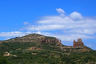
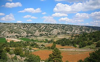
Sierra de los Caballos between Molinos and Berge
Highest point
Peak Las Artigas
Elevation 1,205 m (3,953 ft)
Listing List of mountains in Aragon
Coordinates 40°49′57″N0°25′26″W / 40.83250°N 0.42389°W / 40.83250; -0.42389 Coordinates: 40°49′57″N0°25′26″W / 40.83250°N 0.42389°W / 40.83250; -0.42389
Geography
Relief Map of Spain.png
Red triangle with thick white border.svg
Sierra de Caballos
Location in Spain
Location Maestrazgo, Bajo Aragón,
Aragon
Parent range Iberian System, Eastern zone
Geology
Orogeny Alpine orogeny
Age of rock Mesozoic
Type of rock Dolomite and Marl
Climbing
Easiest route From the towns of Seno, Molinos or Berge
The arid-looking Sierra de Caballos range rising behind Molinos town Molinos50.JPG
The arid-looking Sierra de Caballos range rising behind Molinos town

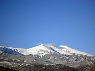
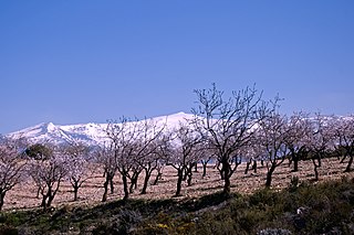
Sierra de Caballos or Sierra de los Caballos is a mountain range in the Maestrazgo and Bajo Aragón comarcas of Aragon, Teruel Province, Spain. The highest point in the range is Las Artigas (1,205 m). The Guadalopillo River flows along the northern side of the range. [1]

Maestrazgo, Aragon Comarca in Aragon, Spain

Maestrazgo is a comarca in southeastern Aragon, Spain. Its names derives from the Maestrat/Maestrazgo mountain massif that extends to the east to the Comarques of the Valencian Community Alt Maestrat and Baix Maestrat. The most important town is Cantavieja. It is bordered by the Aragonese comarcas of Andorra-Sierra de Arcos, Cuencas Mineras, Comunidad de Teruel and Bajo Aragón, in the north and in the west and Gúdar-Javalambre in the south, as well as with the Castellón Province in the east. Some municipal terms of this comarca are part of the historical region of Lower Aragon.

Bajo Aragón Comarca in Aragón, Spain

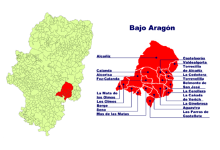
Bajo Aragón is an administrative comarca in eastern central Aragon, Spain. It was first established in 1999. It has a population of 29,358 (2007) and an area of 1.304,2 km². The seat of the comarca is in Alcañiz. It is located in Teruel Province, in the transitional area between the Iberian System and the Ebro Valley.

Comarcas of Aragon Wikimedia list article

Here is a list of the administrative comarcas (counties) in the autonomous community of Aragon in Spain. They were officially delimited in 1999, with substantial changes over a previously proposed division.

Contents

Geography

This arid-looking series of parallel ranges is cut by many ravines. It is located north of Castellote, at the eastern end of the Iberian System, roughly between Molinos and Berge. There are many fossils from the Jurassic and Cretaceous periods in this area.

Castellote Place in Aragon, Spain

Castellote is a municipality located in the province of Teruel, Aragon, Spain. According to the 2010 census, the municipality has a population of 804 inhabitants.

Molinos, Teruel Place in Aragon, Spain

Molinos is a municipality located in the Maestrazgo comarca, province of Teruel, Aragon, Spain. According to the 2010 census the municipality has a population of 303 inhabitants.

Berge, Teruel Place in Aragon, Spain

Berge is a little village and municipality in Bajo Aragón, Teruel Province, Aragon, Spain. According to the 2010 census the municipality has a population of 274 inhabitants.

The Ermita de la Virgen de la Peña near Berge, is in the northern side of the Sierra de Caballos. El Picuezo is an original rock formation near Molinos. The impressive Grutas de Cristal "glass caves" are located in the area of these mountains, within Molinos municipal term. [2]

There are other mountain ranges with the name "Sierra de Caballos" in the world. One of them is in Isla de Pinos, Cuba.

Cuba Country in the Caribbean

Cuba, officially the Republic of Cuba, is a country comprising the island of Cuba as well as Isla de la Juventud and several minor archipelagos. Cuba is located in the northern Caribbean where the Caribbean Sea, Gulf of Mexico and Atlantic Ocean meet. It is east of the Yucatán Peninsula (Mexico), south of both the U.S. state of Florida and the Bahamas, west of Haiti and north of both Jamaica and the Cayman Islands. Havana is the largest city and capital; other major cities include Santiago de Cuba and Camagüey. The area of the Republic of Cuba is 110,860 square kilometres (42,800 sq mi). The island of Cuba is the largest island in Cuba and in the Caribbean, with an area of 105,006 square kilometres (40,543 sq mi), and the second-most populous after Hispaniola, with over 11 million inhabitants.

See also

Related Research Articles

Province of Teruel Province of Spain

Teruel is a province of Aragon, in the northeast of Spain. The capital is Teruel.

Villarluengo Place in Aragon, Spain

Villarluengo is a municipality at the heart of the mountainous Maestrazgo comarca, province of Teruel, Aragon, Spain. According to the 2010 census the municipality has a population of 188 inhabitants.

Guadalope river in Aragon, Spain

The Guadalope is a river in Aragon, Spain. It is a tributary of the Ebro.

Morella, Castellón Place in Valencian Community, Spain

Morella is an ancient walled city located on a hill-top in the province of Castellón, Valencian Community, Spain. The town is the capital and administrative centre of the comarca of Els Ports, in the historic Maestrat (Maestrazgo) region.

Sistema Ibérico mountain range

The Iberian System, is one of the major systems of mountain ranges in Spain. It consists of a vast and complex area of mostly relatively high and rugged mountain chains and massifs located in the central region of the Iberian Peninsula, but reaching almost the Mediterranean coast in the Valencian Country in the east.

Ports de Tortosa-Beseit mountain

Ports de Tortosa-Beseit, also known as Ports de Beseit, or simply as Els Ports[əls ˈpɔɾts] or Lo Port[lu ˈpɔɾt] by locals, is a limestone mountain massif located at the north-eastern end of the Sistema Ibérico, a complex system of mountain ranges and massifs in the centre of the Iberian Peninsula. Its highest point is Mont Caro, 1,441 m. Rivers such as the Matarranya and the Sénia have their source in these mountains.

Moncayo Massif mountain massif in Spain

Moncayo is a 15 km long and about 7 km wide mountain massif giving name to the Tarazona y el Moncayo comarca, Aragon, Spain. The Moncayo's highest summit, San Miguel (2,314 m), is the highest point in the 500 km long Sistema Ibérico.

Pico del Caballo mountain in Spain

Pico del Caballo, Cerro del Caballo or simply Caballo ("horse") is 3,011 m high mountain in the Sierra Nevada, Spain. It is the westernmost three thousander of the range.

Lower Aragon Natural region in Spain

Lower Aragon, also known as Tierra Baja, is a natural and historical region in Aragon, Spain. The name "Lower Aragon" refers to the areas of the lowest altitude within the Ebro river basin, but the historical region encompasses only the river basins of several right tributaries of the Ebro River, namely the Matarranya, Guadalope, Regallo, Martín and Aguas, located between the Ebro and the Iberian mountain range.

Penyagolosa mountain in Spain

Penyagolosa is a mountain in the Alcalatén area, Valencian Community, Spain. Geologically it is part of the Iberian System, located at the eastern end of Iberian Peninsula. Its peak is at 1,813 meters above sea level and is often crowned with snow in the winter.

Sierra de Gúdar mountain in Spain

Sierra de Gúdar is a mountain range in the Gúdar-Javalambre and Maestrazgo comarcas of Aragon and the Alto Mijares comarca of the Valencian Community, Spain. The highest point in the range is Peñarroya (2,019 m).

Sierra de Cucalón mountain in Spain

Sierra de Cucalón is a 25-kilometre (16 mi) long system of mountain ranges in Aragon, Spain, located between the comarcas of Jiloca and Cuencas Mineras.

Sierra Carrascosa

Sierra Carrascosa is a mountain range in the Maestrazgo comarca of Aragon, Teruel Province, Spain. The highest point in the range is Muela Carrascosa (1,214 m). The Guadalope River flows along the NW side of the range.

Sierra de San Just mountain in Spain

Sierra de San Just is a mountain range in the Cuencas Mineras comarca of Aragon, Teruel Province, Spain. The highest point in the range is San Just (1,522 m). This range is located in one of the coldest and most rugged regions of Aragon.

Sierra de Vicort mountain in Spain

Sierra de Vicort, also known as Sierra de Vicor, is a 20 km (12 mi) long mountain range in the Comunidad de Calatayud and Campo de Daroca comarcas of Aragon, Spain.

Sierra de Solorio

The Solorio Range is a mountain range located in the western side of the Iberian System, Spain. It straddles Aragon, Castile-La Mancha and Castile and León.

References

  1. "Guadalopillo" (in Spanish). Gran Enciclopedia Aragonesa. Retrieved 2011-05-30.
  2. Caves in Maestrazgo Archived 2008-05-19 at the Wayback Machine .