
Pembroke is a small historic town in Plymouth County, Massachusetts, United States. Pembroke is a South Shore suburb of the Boston metropolitan area. The town is located about halfway between Boston and Cape Cod. As of 2021, the median home value in Pembroke was $529,000. The population was 17,837 at the 2010 census.

Kingston is a coastal town in Plymouth County, Massachusetts, United States. The population was 12,629 at the 2010 census.

Silver Lake is a residential and commercial neighborhood in the east-central region of Los Angeles, California. Originally named Ivanhoe in the 1900s by a resident from Scotland, it was built around what was then a city reservoir which gives the district its name. Silver Lake is named after Herman Silver, a local politician who helped create the reservoir. The area is also known for its restaurants, painted staircases and hipster hangouts, and many notable people have made their homes there. The neighborhood has several public and private schools.

Silver Lake, formerly known as Long Pond, is a small lake in the town of Hollis, New Hampshire, United States. The lake was formerly surrounded by summer vacation cottages and camps, but most of these buildings have now been converted for use as year-round homes. Silver Lake State Park occupies the northern end of the lakeshore.

Silver Lake is the name of both a reservoir and an adjacent neighborhood in the New York City borough of Staten Island.

King Michael I Park, formerly Herăstrău Park, is a large park on the northern side of Bucharest, Romania, around Lake Herăstrău, one of the lakes formed by the Colentina River.

The North Shore of Lake Superior runs from Duluth, Minnesota, United States, at the southwestern end of the lake, to Thunder Bay and Nipigon, Ontario, Canada, in the north to Sault Ste. Marie, Ontario, in the east. The shore is characterized by alternating rocky cliffs and cobblestone beaches, with forested hills and ridges through which scenic rivers and waterfalls descend as they flow to Lake Superior.
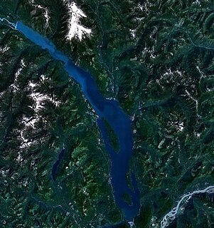
Harrison Lake is the largest lake in the southern Coast Mountains of Canada, being about 250 square kilometres (95 mi²) in area. It is about 60 km (37 mi) in length and at its widest almost 9 km (5.6 mi) across. Its southern end, at the resort community of Harrison Hot Springs, is c. 95 km east of downtown Vancouver. East of the lake are the Lillooet Ranges while to the west are the Douglas Ranges. The lake is the last of a series of large north-south glacial valleys tributary to the Fraser along its north bank east of Vancouver, British Columbia. The others to the west are the Chehalis, Stave, Alouette, Pitt, and Coquitlam Rivers.
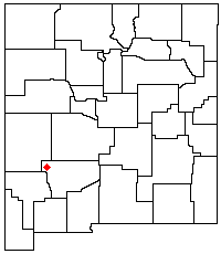
The Black Range is an igneous mountain range running north–south in Sierra and Grant counties in southwest New Mexico, in the southwestern United States. Its central ridge forms the western and eastern borders, respectively, of the two counties through much of their contact. The range is about 55 miles (88 km) long from north to south and up to 18 miles (29 km) wide. The highest point is McKnight Mountain. The Black Range lies almost entirely within the Gila National Forest. The Mimbres River originates from the mountain snow pack and run-off. The Mimbres Mountains, the southernmost part of the range, are usually included as part of the Black Range.
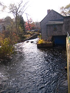
The Jones River is a 7.5-mile-long (12.1 km) river running through Kingston, Massachusetts. The river drains about 30 square miles (78 km2), has its source in Silver Lake and drains into Kingston Bay. Land surrounding the river is 52% forested, of which 22% has been developed for residential use. There is a USGS stream gauge along 16 square miles (41 km2) of the river and it has measured the flow at 0.7 cubic feet per second (0.020 m3/s) per square mile of drainage area.
Secondary Highway 599, commonly referred to as Highway 599, is a provincially maintained secondary highway in the Canadian province of Ontario. The 291.0 km (180.8 mi) route connects Highway 17 near Ignace with the remote northern community of Pickle Lake; its terminus at Pickle Lake marks the northernmost point on the provincial highway system. Highway 599 was first assigned in 1956 between Savant Lake and Pickle Lake, although it did not connect with the rest of the provincial highway system at the time. Construction to link it with Highway 17 in Ignace took place between 1958 and 1966. The northern end of Highway 599 is one of two possible starting points for a road to the Ring of Fire mineral deposits, the other being Highway 584 in Nankina.

Silver Lake is an unincorporated community and census-designated place in western Lake County, Oregon, United States, along Oregon Route 31. As of the 2010 census, it had a population of 149. Facilities include a gas station and a small store, a post office, and a public school, North Lake School, serving grades K-12.
Silver City is an unincorporated community in Pennington County, South Dakota, United States, outside Rapid City. It lies at the head of Pactola Lake on Rapid Creek, and is about 5 miles west of U.S. Route 385 via a paved county road. It is not tracked by the U.S. Census Bureau.

Silver Springs State Fish and Wildlife Area is an Illinois state park on 1,350 acres (550 ha) in Kendall County, Illinois, United States. The park was established in the late 1960s and is named for the natural spring within its boundaries. The park has two artificial lakes and the Fox River flows through the northern end of the park. Silver Springs hosts a variety of activities including fishing, hunting, boating and hiking. The park has areas of native prairie restoration, a sledding hill and a seven-mile (11 km) equestrian trail. The prairie restoration areas hold many species of plants including lead plant, and purple coneflower.

Silver Spring is an unincorporated community located in West Hempfield Township in Lancaster County, Pennsylvania. The community is located along Pennsylvania Route 23.

June Lake is a census-designated place in Mono County, California. It is located against the southern rim of the Mono Basin, 12.5 miles (20 km) south of Lee Vining, at an elevation of 7654 feet.

The community of Wyman Park is a border community that links Hampden to Roland Park. All of the Wyman Park areas were annexed to Baltimore City in 1888. The general boundaries consist of the area from south to north between 33rd Street and 40th Streets and west to east from Keswick Road to Wyman Park. South of 40th Street, garden apartments, multi-story apartment buildings, and single-family residences have been built. People here tend to relate to the north along 40th Street and University Parkway and The Johns Hopkins University. The Wyman Park also accommodates the Union Soldiers and Sailors Monument, located at 29th and Charles Street, and the now removed Stonewall Jackson and Robert E. Lee Monument that has been rededicated as Harriet Tubman Grove on Art Museum Drive.

Silver Lake is an unincorporated community in Preston County, West Virginia, United States. Silver Lake is located along U.S. Route 219, 7.5 miles (12.1 km) north of Thomas in Tucker County.

The Muisca raft, sometimes referred to as the El Dorado Raft, is an artistic figure of pre-Columbian gold votive, drafted by the Muisca who established one of the four grand civilisations in the Americas on the Altiplano Cundiboyacense in the Eastern Ranges of the Colombian Andes. The piece is exhibited at the Gold Museum in Bogota. It is estimated that the figure was drawn between 600 and 1600 AD by lost-wax casting in gold with a small amount of copper.
