Custer Ridge (Mount Custer) (8,630 feet (2,630 m)) is a ridge in North Cascades National Park in the U.S. state of Washington. Located in the northern section of the park, Custer Ridge rises to the west of Silver Lake, 1.4 mi (2.3 km) north-northwest of Mount Spickard. The high point along Custer Ridge is a peak tentatively named Mount Custer, which lies near the southwestern end of the ridge. Custer Ridge extends beyond the Canada–US border.

Alta Mountain is a 6,275-foot (1,913-metre) mountain summit located in Kittitas County of Washington state. It is set within the Alpine Lakes Wilderness which is part of the Cascade Range. Alta Mountain is situated on land managed by Wenatchee National Forest. Precipitation runoff from the mountain drains into tributaries of the Yakima River.

Prairie Mountain is a 5,678-foot-elevation mountain summit near the western edge of the North Cascades, in Snohomish County of Washington state. It is located six miles east of Darrington, Washington, and northwest of Glacier Peak which is one of the Cascade stratovolcanoes. It is situated on land administered by the Mount Baker-Snoqualmie National Forest. The nearest higher peak is White Chuck Mountain, 4.7 miles (7.6 km) to the south-southeast. Precipitation runoff from Prairie Mountain drains into the Sauk River and Suiattle River, both tributaries of the Skagit River. The mountain was so named because of the beautiful prairie at its base.

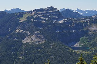
Snowking Mountain is a 7,433-foot (2,266-metre) summit located in Skagit County of Washington state. Situated within the Glacier Peak Wilderness, Snowking Mountain is positioned west of the crest of the North Cascades, approximately 18 miles northeast of the town of Darrington. It is set within the Glacier Peak Wilderness, on land managed by Mount Baker–Snoqualmie National Forest. Snowking has two subsidiary peaks, West Peak (7,425 ft), and Middle Peak (7,400 ft). A broad unnamed glacier known colloquially as Snowking Glacier rests on the north face. Downslope of that glacier are Snowking Lake, Found Lake, and Cyclone Lake. Mount Tommy Thompson is three miles to the northwest, and the nearest higher neighbor is Mount Misch, 5.75 miles (9.25 km) to the southeast. Precipitation runoff from Snowking Mountain drains into tributaries of the Skagit River.

Cashmere Mountain is an 8,514-foot (2,595-metre) mountain summit located in Chelan County of Washington state. Cashmere Mountain is situated within the Alpine Lakes Wilderness, on land managed by the Okanogan–Wenatchee National Forest. It is part of the Wenatchee Mountains which are subset of the Cascade Range. The nearest higher neighbor is Cannon Mountain, 4.4 mi (7.1 km) to the southeast. Precipitation runoff from this mountain drains into tributaries of Icicle Creek, which in turn is a tributary of the Wenatchee River.
Terrace Mountain is a 6,361-foot (1,939-metre) mountain summit located in the Alpine Lakes Wilderness in eastern King County of Washington state. It is part of the Cascade Range and is situated on land managed by Mount Baker-Snoqualmie National Forest. The peak is situated 4 mi (6.4 km) north of Mount Daniel, and is surrounded by Lake Clarice, Marmot Lake, Ptarmigan Lakes, and the Terrace Lakes. Precipitation runoff from the mountain drains into tributaries of the Skykomish River. Topographic relief is significant as the summit rises over 1,800 feet above Lake Clarice in less than one-half mile (0.8 km). The mountain's descriptive name stems from the terrace-like appearance created by a series of benches on its east aspect.
Sperry Peak is a 6,120+ ft mountain summit in Snohomish County of Washington state.

Pelton Peak is a 7,133-foot (2,174-metre) mountain summit located in Chelan County of Washington state. It is part of the North Cascades, a subset of the Cascade Range. Pelton Peak is situated 1.8 miles (2.9 km) southeast of Cascade Pass in North Cascades National Park near the northern end of the Ptarmigan Traverse. The nearest higher peak is Magic Mountain, 0.4 miles (0.64 km) to the southwest. The Yawning Glacier rests on its western flank between these two peaks. Surface runoff from the mountain drains into tributaries of the Stehekin River. The mountain's name comes from the Pelton wheel which was used in early mining times, and several mines were located in the vicinity of Pelton Basin, Horseshoe Basin, and Boston Basin.

Bandit Peak is a 7,625-foot (2,324-metre) double-summit granitic mountain located in the Glacier Peak Wilderness of the North Cascades, in Chelan County of Washington state. The mountain is situated east of the crest of the Cascade Range, on land managed by the Okanogan–Wenatchee National Forest. Its nearest higher neighbor is Brahma Peak, 5.9 mi (9.5 km) to the north. Bandit Peak is the ninth-highest peak on Chiwawa Ridge, and other notable peaks on this ridge include Mount Berge, Buck Mountain, Cirque Mountain, Napeequa Peak, Helmet Butte, and Chiwawa Mountain. Precipitation runoff from Bandit Peak drains west into Napeequa River; or east into the Chiwawa River.
Mount Roosevelt is a 5,835-foot (1,779-metre) mountain summit located six miles (9.7 km) northwest of Snoqualmie Pass, in east King County of Washington state. It's part of the Cascade Range and is situated within the Alpine Lakes Wilderness, on land managed by Mount Baker-Snoqualmie National Forest. Mount Roosevelt is set above the western shore of Snow Lake, and two miles (3.2 km) immediately north of Kaleetan Peak, which is the nearest higher neighbor. Precipitation runoff from the mountain drains into tributaries of the Snoqualmie River. This mountain's toponym was officially adopted in 1989 by the U.S. Board on Geographic Names.

Malachite Peak is a 6,261-foot (1,908-metre) mountain summit located 5.5 mi (8.9 km) south of Skykomish, in eastern King County of Washington state. It's part of the Cascade Range, and is situated one mile north of Lake Malachite in the Alpine Lakes Wilderness, on land managed by Mount Baker-Snoqualmie National Forest. Precipitation runoff from the mountain drains into tributaries of the Skykomish River. The nearest higher neighbor is Camp Robber Peak, 3.66 mi (5.89 km) to the south. The first ascent of this peak may have been in 1937 by a team from the United States Geological Survey. The USGS named the peak about 1975 based on a triangulation station marked as "Malachite".

Mount Hermann is a 6,240+ ft Skagit Range summit located northwest of Mount Shuksan and northeast of Mount Baker, in the North Cascades of Washington state. It is situated in the Mount Baker Wilderness, on land managed by Mount Baker-Snoqualmie National Forest. Mount Hermann is located immediately west of the Mt. Baker Ski Area, at the end of the Mount Baker Highway. Precipitation runoff from the mountain drains into tributaries of the Nooksack River. This peak is named for Binger Hermann (1843–1926), head of the United States General Land Office. This geographic feature has also had variant names "Mount Herman", and "Herman Peak". The present toponym and spelling was officially adopted in 1988 by the U.S. Board on Geographic Names.

Three Queens is a prominent 6,693-foot (2,040-metre) triple-summit mountain located in the Cascade Range, in Kittitas County of Washington state. It is set within the Alpine Lakes Wilderness on land managed by Wenatchee National Forest. The East Peak is the highest, and its subpeaks are the Middle Peak, and West Peak. Three Queens is set 6.5 miles (10.5 km) east-northeast of Snoqualmie Pass, on Chikamin Ridge, 2.76 miles (4.44 km) southeast of its nearest higher neighbor, Chikamin Peak. The Pacific Crest Trail traverses the west slope of Three Queens as it crosses the gap between Four Brothers and Three Queens. Precipitation runoff from the mountain drains into tributaries of the Yakima River drainage basin. The first ascent was likely made in 1925 by a party of eight Mountaineers led by Glen Bremerman and C. A. Fisher. This mountain's toponym was officially adopted in 1940 by the United States Board on Geographic Names.

Big Jim Mountain is a 7,763-foot (2,366-metre) mountain summit located in Chelan County of Washington state. It is situated 9 mi (14 km) northwest of Leavenworth, within the Alpine Lakes Wilderness, on land managed by the Okanogan–Wenatchee National Forest. Big Jim Mountain is the fourth-highest peak in the Chiwaukum Mountains, a subset of the Cascade Range. Its nearest higher neighbor is Big Lou, 1.75 mi (2.82 km) to the south-southwest, and Cape Horn is set 4 mi (6.4 km) to the west. Precipitation runoff from Big Jim drains into tributaries of the Wenatchee River. Although modest in elevation, relief is significant since Big Jim rises 2,300 feet above Painter Creek Valley in one mile. Big Jim Mountain is named for Jim Whittaker, the first American to summit Mount Everest and twin brother of Lou Whittaker.

Big Lou is a 7,780+ ft mountain summit located in Chelan County of Washington state. It is situated 8.5 mi (13.7 km) west-northwest of Leavenworth, on the boundary of the Alpine Lakes Wilderness, and on land managed by the Okanogan–Wenatchee National Forest. Big Lou is the highest point on Icicle Ridge, and is the third-highest peak in the Chiwaukum Mountains, a subset of the Cascade Range. Its nearest higher neighbor is Snowgrass Mountain, 5 mi (8.0 km) to the northwest, and slightly lower Big Jim Mountain is set 1.75 mi (2.82 km) to the north-northeast. Precipitation runoff from Big Lou drains into Icicle Creek and other tributaries of the Wenatchee River. Although modest in elevation, relief is significant since Big Lou rises 5,200 feet above Icicle Creek Valley in approximately two miles. Big Lou is named for mountaineer Lou Whittaker, the twin brother of Jim Whittaker, the first American to summit Mount Everest.

Bald Eagle Peak is a 6,259-foot (1,908-metre) mountain summit located 7.4 mi (11.9 km) southeast of Skykomish, in eastern King County of Washington state. It's part of the Cascade Range, and is situated in the Alpine Lakes Wilderness, on land managed by Mount Baker-Snoqualmie National Forest. Precipitation runoff from this mountain drains into tributaries of the Foss River. This peak is set on the divide between the east and west forks of Foss River. The nearest neighbor is Silver Eagle Peak, 1.1 mi (1.8 km) to the southwest, and Bald Eagle Lake lies in a cirque midway between the pair. The first ascent of this peak was made in 1933 by Hermann Ulrichs and Ben Falkenburg via the North Ridge. This mountain's toponym and correct location was officially adopted September 8, 1988, by the U.S. Board on Geographic Names. Some older maps will have this peak erroneously labeled at Silver Eagle Peak's location.
Silver Eagle Peak is a 6,241-foot (1,902-metre) mountain summit located 7.7 mi (12.4 km) southeast of Skykomish, in eastern King County of Washington state. It is part of the Cascade Range, and is situated in the Alpine Lakes Wilderness, on land managed by Mount Baker-Snoqualmie National Forest. Precipitation runoff from this mountain drains into tributaries of the Foss River. This peak is set on the divide between the east and west forks of Foss River. Malachite Peak is set 2.6 mi (4.2 km) to the west-northwest, and the nearest higher neighbor is Bald Eagle Peak, 1.1 mi (1.8 km) to the northeast. Bald Eagle Lake lies in a cirque midway between Silver Eagle and Bald Eagle. The first ascent of this peak was made in 1934 by Hermann Ulrichs and three companions. This mountain's toponym was officially adopted September 8, 1988, by the U.S. Board on Geographic Names. Some older maps will have this peak erroneously labeled as Bald Eagle Peak.
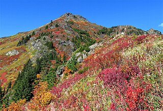
Yellow Aster Butte is a 6,241-foot (1,902-metre) Skagit Range summit located three miles south of the Canada–United States border, in Whatcom County of Washington state. It is situated within the Mount Baker Wilderness, on land managed by Mount Baker-Snoqualmie National Forest. The nearest higher neighbor is Winchester Mountain, 1.77 miles (2.85 km) to the east, and Mount Larrabee is set 2.3 miles (3.7 km) to the northeast. The summit offers views of Mount Larrabee, Tomyhoi Peak, American Border Peak, Canadian Border Peak, Mount Shuksan, and Mount Baker. Precipitation runoff on the north side of the mountain drains into Tomyhoi Creek, whereas the west side of the mountain drains into Damfino Creek, and the south slope is drained by Swamp Creek.
Mother Lode is a 7,905-foot-elevation (2,409-meter) mountain summit located in the North Cascades, in Okanogan County, Washington. It is situated in the Lake Chelan-Sawtooth Wilderness, on land managed by Okanogan–Wenatchee National Forest. The mountain is part of the Methow Mountains, which are a subset of the Cascade Range, and the peak is approximately two miles east of the crest of the range. Mother Lode is set approximately six miles south of Washington Pass, and the nearest higher neighbor is Gilbert Mountain, three miles to the northeast. Topographic relief is significant as the north aspect rises 3,500 feet above the South Fork Twisp River in one mile. The peak was climbed in 1983 by Rick La Belle and Glen Sterr via the north ridge, and the northeast ridge was climbed in 1985 by Carl and Gordon Skoog. Precipitation runoff from the peak drains into tributaries of Twisp River, which in turn is a tributary of the Methow River.
Majestic Mountain is a 7,530-foot-elevation (2,295-meter) mountain summit located in Whatcom County in Washington state.


