Smallwood, New York

Last updated

Smallwood, New York
Sullivan County New York incorporated and unincorporated areas Smallwood highlighted.svg
Location of Smallwood in Sullivan County, New York
Coordinates: 41°39′38″N74°48′52″W / 41.66056°N 74.81444°W / 41.66056; -74.81444
Country United States
State New York
County Sullivan
Area
[1]
  Total2.53 sq mi (6.55 km2)
  Land2.40 sq mi (6.22 km2)
  Water0.13 sq mi (0.32 km2)
Elevation
1,201 ft (366 m)
Population
 (2020)
  Total839
  Density349.15/sq mi (134.83/km2)
Time zone UTC-5 (Eastern (EST))
  Summer (DST) UTC-4 (EDT)
ZIP code
12778
Area code 845
FIPS code 36-67730
GNIS feature ID0965447

Smallwood is a hamlet (and census-designated place) in Sullivan County, New York, United States. The population was 839 at the 2020 census.

Contents

Smallwood is in the southeastern section of the Town of Bethel and is a hamlet within the town of Bethel. It was founded in the 1920s as the vacation community "Mountain Lakes", but was later renamed after its founder A.N. Smallwood.

History

Smallwood is known for its early-20th century style log cabins and camps constructed by immigrants in the 1930s. A unique feature of the community is that the original home construction materials were locally sourced: Smallwood cabins were constructed of wood lumbered and milled on site, and the distinctive stone fireplaces found in most cabins were built of limestone quarried in Smallwood in the 1920s to 1950s. Most of these historic cabin structures survive as both summer and year-round residences.

The Smallwood development, as envisioned by developer A.N. Smallwood, was originally a "restricted" community, i.e., homes were available only to individuals who were eligible for membership in the Mountain Lakes Country Club, which was restricted to "caucasians of the Christian faith," according to literature and sales brochures. This began to change in the 1940s, but many deeds contained exclusionary covenants into the 1950s. In the past few decades, the community has become very diverse, comprising local year-round residents as well as summer-home owners who hail primarily from the New York City metropolitan area and from South Florida.

Municipal tap water for many Smallwood homes is only available on a seasonal basis from April to October. Other homes which have been winterized have wells.

Recreation

Centrally located in the Hamlet of Smallwood, Mountain Lake is a private holding of the Smallwood Civic Association (SWCA). Only dues paying members of the Association have access to the approximate 65 acre man-made Lake and other facilities owned and operated by the SWCA such the as a beach, tennis and pickelball courts, basketball court, playground, ball field, and Lodge. Minnie Falls is a popular water fall and part of a large public park operated by the Town of Bethel called, The Forest Reserve at Smallwood. The Reserve features hiking trails for year-round outdoor activities as well as a large dog park The Falls are part of White Lake Brook, a water system which, upon entering Smallwood becomes Mountain Lake, and upon crossing over the lake’s dam becomes White Lake Brook again. The Club at Smallwood, also located in the community, is also private. While an entity separate from the SWCA, some “Smallwoodians” maintain memberships in both organizations.The Club offers a heated pool and recreational activities in the summer months. Both the Civic Association and Club at Smallwood are open to dues-paying residents. Smallwood residents also have access to the nearby and public, Lake Superior State Park(operated by Sullivan County)and the public Toronto Reservoir, which is adjacent to Smallwood and located at the end of Pine Grove Road. The Toronto access — permitted by the Federal Energy Regulatory Commission (FERC) allows for swimming and has a public motor-boat launch for fishing and other boating activities.

Geography

Smallwood is located at 41°39′38″N74°48′52″W / 41.66056°N 74.81444°W / 41.66056; -74.81444 (41.660573, -74.814507). [2]

According to the United States Census Bureau, the CDP has a total area of 1.6 square miles (4.1 km2), of which 1.5 square miles (3.9 km2) is land and 0.1 square miles (0.26 km2) (6.06%) is water.

Demographics

Historical population
CensusPop.Note
2010 580
2020 83944.7%
U.S. Decennial Census [3]

As of the census [4] of 2000, there were 566 people, 259 households, and 148 families residing in the CDP. The population density was 365.5 inhabitants per square mile (141.1/km2). There were 1,012 housing units at an average density of 653.5 per square mile (252.3/km2). The racial makeup of the CDP was 96.47% White, 0.88% African American, 0.71% Native American, 0.88% from other races, and 1.06% from two or more races. Hispanic or Latino of any race were 3.53% of the population.

There were 259 households, out of which 22.0% had children under the age of 18 living with them, 46.3% were married couples living together, 8.9% had a female householder with no husband present, and 42.5% were non-families. 36.3% of all households were made up of individuals, and 15.8% had someone living alone who was 65 years of age or older. The average household size was 2.17 and the average family size was 2.86.

In the CDP, the population was spread out, with 20.0% under the age of 18, 5.1% from 18 to 24, 24.9% from 25 to 44, 30.7% from 45 to 64, and 19.3% who were 65 years of age or older. The median age was 45 years. For every 100 females, there were 97.2 males. For every 100 females age 18 and over, there were 100.4 males.

The median income for a household in the CDP was $46,845, and the median income for a family was $52,396. Males had a median income of $50,104 versus $50,375 for females. The per capita income for the CDP was $31,035. About 6.9% of families and 8.9% of the population were below the poverty line, including 10.3% of those under age 18 and 19.4% of those age 65 or over.

Related Research Articles

<span class="mw-page-title-main">Lake Shore, Maryland</span> Census-designated place in Maryland, United States

Lake Shore is a census-designated place and unincorporated community in Anne Arundel County, Maryland, United States, located east of Pasadena. The population of Lake Shore was 19,477 at the 2010 census.

<span class="mw-page-title-main">Mattapoisett Center, Massachusetts</span> Census-designated place in Massachusetts, United States

Mattapoisett Center is a census-designated place (CDP) in the town of Mattapoisett in Plymouth County, Massachusetts. The population was 2,915 at the 2010 census.

<span class="mw-page-title-main">Harvey, Michigan</span> Census-designated place & unincorporated community in Michigan, United States

Harvey is a census-designated place (CDP) in Marquette County in the U.S. state of Michigan. The population was 3,244 as of the 2020 census, up from 1,393 in 2010, before the CDP was enlarged by the Census Bureau. The CDP is located within Chocolay and Sands townships.

<span class="mw-page-title-main">Hillside Lake, New York</span> Census-designated place in New York, United States

Hillside Lake is a hamlet and census-designated place (CDP) in Dutchess County, New York, United States. The population was 1,084 at the 2010 census. It is part of the Poughkeepsie–Newburgh–Middletown, NY Metropolitan Statistical Area as well as the larger New York–Newark–Bridgeport, NY-NJ-CT-PA Combined Statistical Area.

<span class="mw-page-title-main">Angola on the Lake, New York</span> Census-designated place in New York, United States

Angola on the Lake is a hamlet and census-designated place (CDP) in Erie County, New York, United States. The population was 1,675 at the 2010 census. It is part of the Buffalo–Niagara Falls Metropolitan Statistical Area.

<span class="mw-page-title-main">Scotchtown, New York</span> Hamlet and CDP in New York, United States

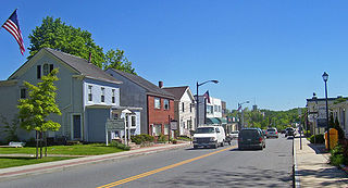
Scotchtown is a hamlet in the Town of Wallkill, in Orange County, New York, United States. The population was 10,578 at the 2020 census. It has the ZIP Code 10941. The hamlet is located east of the City of Middletown. It is part of the Poughkeepsie–Newburgh–Middletown, NY Metropolitan Statistical Area as well as the larger New York–Newark–Bridgeport, NY-NJ-CT-PA Combined Statistical Area.

<span class="mw-page-title-main">Carmel Hamlet, New York</span> Hamlet and Census-designated place in New York, United States

Carmel Hamlet, commonly known simply as Carmel, is a hamlet and census-designated place (CDP) located in the Town of Carmel in Putnam County, New York, United States. As of the 2010 census, the population was 6,817.

<span class="mw-page-title-main">Lake Carmel, New York</span> Census-designated place in New York, United States

Lake Carmel is a hamlet and census-designated place in the town of Kent in Putnam County, New York, United States. The home of over half of the town of Kent's population of 8,282, the hamlet is centered around Lake Carmel, a 1.6 mile long manmade lake in the southeastern corner of the township and just north of hamlet of Carmel within the town of Carmel.

Star Lake is a hamlet in the Adirondack Mountains of St. Lawrence County, New York, United States. The population was 809 at the 2010 census.

<span class="mw-page-title-main">Bethel, New York</span> Town in New York, United States

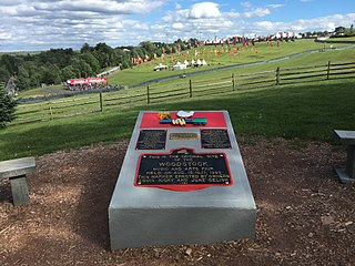
Bethel is a town in Sullivan County, New York, United States. The population was estimated at 3,959 in 2020. The town received worldwide attention after it served as the location of Woodstock in 1969, which was originally planned for Wallkill, New York, but was relocated to Bethel after Wallkill withdrew.

<span class="mw-page-title-main">Rock Hill, New York</span> CDP in New York, United States

Rock Hill is a hamlet in Sullivan County, New York, United States. At the 2020 census the population was 2,369.

<span class="mw-page-title-main">Clintondale, New York</span> CDP in New York, United States

Clintondale is a hamlet in Ulster County, New York, United States. The population was 1,938 at the 2020 census.

<span class="mw-page-title-main">Lake Katrine, New York</span> CDP in New York, United States

Lake Katrine is a hamlet in Ulster County, New York, United States. The population was 2,522 at the 2020 census.

<span class="mw-page-title-main">Rifton, New York</span> CDP in New York, United States

Rifton is a hamlet in Ulster County, New York, United States. The population was 481 at the 2020 census.

<span class="mw-page-title-main">Goldens Bridge, New York</span> Census-designated place in New York, United States

Goldens Bridge is a hamlet and census-designated place (CDP) in the town of Lewisboro in Westchester County, New York, United States. The population was 1,630 at the 2010 census.

<span class="mw-page-title-main">Crystal Lakes, Ohio</span> Census-designated place in Ohio, United States

Crystal Lakes is a census-designated place (CDP) in Clark County, Ohio, United States. The population was 1,394 at the 2020 census. It is part of the Springfield, Ohio Metropolitan Statistical Area.

<span class="mw-page-title-main">Canadohta Lake, Pennsylvania</span> Census-designated place in Pennsylvania, United States

Canadohta Lake, otherwise known as “Cam-adohta Lake”, is a census-designated place (CDP) in Crawford County, Pennsylvania, United States. The population was 516 at the 2010 census. The current mayor is John Rudolchick.

<span class="mw-page-title-main">Frederickson, Washington</span> CDP in Washington, United States

Frederickson is a census-designated place (CDP) in Pierce County, Washington, United States. The population was 24,906 at the 2020 census.

<span class="mw-page-title-main">Gardiner (CDP), New York</span> CDP in New York, United States

Gardiner is a hamlet in Ulster County, New York, United States. The population was 952 at the 2020 census.

<span class="mw-page-title-main">Plattekill (CDP), New York</span> CDP in New York, United States

Plattekill is a hamlet in Ulster County, New York, United States. The population was 1,296 at the 2020 census. The community, as is the town, is named after a local stream, the Platte Kill.

References

  1. "ArcGIS REST Services Directory". United States Census Bureau. Retrieved September 20, 2022.
  2. "US Gazetteer files: 2010, 2000, and 1990". United States Census Bureau. February 12, 2011. Retrieved April 23, 2011.
  3. "Census of Population and Housing". Census.gov. Retrieved June 4, 2016.
  4. "U.S. Census website". United States Census Bureau . Retrieved January 31, 2008.