Smith Point, Texas

Last updated

Smith Point, Texas
TXMap-doton-Anahuac.PNG
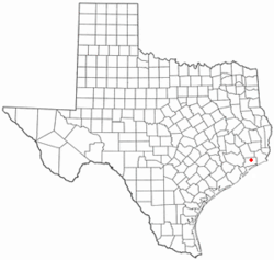
Location of Smith Point, Texas
Coordinates: 29°32′13″N94°45′38″W / 29.53694°N 94.76056°W / 29.53694; -94.76056
Country United States
State Texas
County Chambers
Elevation
[1]
7 ft (2 m)
Time zone UTC-6 (Central (CST))
  Summer (DST) UTC-5 (CDT)
Area code 409
GNIS feature ID1347284 [1]

Smith Point is an unincorporated community in Chambers County, Texas, United States. [1] According to the Handbook of Texas, the community had a population of 150 in 2000. [2] It is located within the Greater Houston metro area.

Contents

History

En route to fortifying the unrest-plagued town at Atascosito in 1805, Spanish troops made landfall there. The area was most likely named in honor of John Smith, who in 1827 signed a petition denouncing Mexico for refusing to award land claimants in the Atascosito district title. In 1876, the Smith Point post office opened for business. Before the invention of the vehicle, Smith Point inhabitants relied mostly on water transportation for their travels. The 1930s saw about fifty people living at Smith Point. Before oil was discovered in 1944, the main sources of income for the local population were ranching and fishing. Since then, a large number of offshore and onshore oil and gas wells have been drilled. The bayfront community was identified in 1986 by several houses, summer cottages, oil and gas wells, and small fishing businesses, despite the post office closing in 1943. The population was 150 in 1990. In 2000, the population did not change. [2] The population went up to 180 in 2010. [3]

The Great Texas Coastal Birding Trail has a 20-foot observation tower in Smith Point that offers views of broad-winged hawks and other bird species. [4] It is also home to the Candy Cain Abshier Wildlife Management Area. [5]

Geography

Smith Point is located on Farm to Market Road 562 and overlooks East Bay and Trinity Bay, 65 mi (105 km) southwest of Beaumont, 72 mi (116 km) southeast of Houston, and 24 mi (39 km) south of Anahuac in southern Chambers County. [3] It is also 20 mi (32 km) from Galveston. [2]

Education

Anahuac Independent School District operates schools in the area.

See also

Related Research Articles

<span class="mw-page-title-main">Chambers County, Texas</span> County in Texas, United States

Chambers County is a county in the U.S. state of Texas. As of the 2020 census, its population was 46,571. The county seat is Anahuac. Chambers County is one of the nine counties that comprise Greater Houston, the Houston–The Woodlands–Sugar Land metropolitan statistical area.

<span class="mw-page-title-main">Anahuac, Texas</span> City in Texas, United States

Anahuac is a city in the U.S. state of Texas on the coast of Trinity Bay. The population of the city was 1,980 at the 2020 census. Anahuac is the seat of Chambers County and is situated in Southeast Texas. The Texas Legislature designated the city as the "Alligator Capital of Texas" in 1989. Anahuac hosts an annual alligator festival.

<span class="mw-page-title-main">Galveston Bay</span> Estuary bay near Houston on the Texas Gulf Coast

Galveston Bay is a bay in the western Gulf of Mexico along the upper coast of Texas. It is the seventh-largest estuary in the United States, and the largest of seven major estuaries along the Texas Gulf Coast. It is connected to the Gulf of Mexico and is surrounded by sub-tropical marshes and prairies on the mainland. The water in the bay is a complex mixture of sea water and fresh water, which supports a wide variety of marine life. With a maximum depth of about 10 feet (3 m) and an average depth of only 6 feet (2 m), it is unusually shallow for its size.

<span class="mw-page-title-main">Clear Lake (region)</span> Region in Texas, United States

Clear Lake, or the Clear Lake Area, is a region in parts of Harris and Galveston County in Texas, United States. It is part of the Galveston Bay Area, which itself is a section of the Houston–The Woodlands–Sugar Land metropolitan area. The area is geographically characterized by the bodies of water in it and around it, including Clear Lake, Taylor Lake, Clear Creek, and Galveston Bay.

<span class="mw-page-title-main">Matagorda Bay</span> Bay on the Texas coast, United States of America

Matagorda Bay is a large Gulf of Mexico bay on the Texas coast, lying in Calhoun and Matagorda counties and located approximately 80 miles (130 km) northeast of Corpus Christi, 143 miles (230 km) east-southeast of San Antonio, 108 miles (174 km) south-southwest of Houston, and 167 miles (269 km) south-southeast of Austin. It is one of seven major estuaries along the Gulf Coast of Texas and serves as the mouth of numerous streams, most notably the Lavaca and Colorado Rivers. The Texas seaport of Port Lavaca is located on the system's northwestern extension of Lavaca Bay. The city of Palacios is found on northeastern extension of Tres Palacios Bay, and Port O'Connor is located on the southwestern tip of the main bay's shore. The ghost town of Indianola, which was a major port before it was destroyed by two hurricanes in the late 19th century, is also found on the bay.

<span class="mw-page-title-main">Corpus Christi Bay</span> Estuary bay on the Texas coast

Corpus Christi Bay is a scenic semi-tropical bay on the Texas coast found in San Patricio and Nueces counties, next to the major city of Corpus Christi. It is separated from the Gulf of Mexico by Mustang Island, and is fed by the Nueces River and Oso Creek from its western and southern extensions, Nueces Bay and Oso Bay. The bay is located approximately 136 miles (219 km) south of San Antonio, and 179 miles (288 km) southwest of Houston.

Wallisville is an unincorporated town in northern Chambers County, Texas, United States. According to the Handbook of Texas, the community had a population of 460 in 2000. It is located within the Greater Houston metropolitan area.

Hankamer is an unincorporated populated place in northern Chambers County, Texas, United States. According to the Handbook of Texas, the community had a population of 525 in 2000. It is located within the Greater Houston metro area.

<span class="mw-page-title-main">Galveston Bay Area</span> Region in Texas, United States of America

The Galveston Bay Area, also known as Bay Area Houston or simply the Bay Area, is a region that surrounds the Galveston Bay estuary of Southeast Texas in the United States, within Houston–The Woodlands–Sugar Land metropolitan area. Normally the term refers to the mainland communities around the bay and excludes Galveston as well as most of Houston.

<span class="mw-page-title-main">Anahuac National Wildlife Refuge</span> National Wildlife Refuge near Anahuac, Texas

The Anahuac National Wildlife Refuge (NWR) is a wildlife conservation area along the coast of Texas (USA), west of the town of High Island, Texas. It borders East Bay, part of the Galveston Bay complex, behind Bolivar Peninsula at the Gulf of Mexico.

Monroe City is an unincorporated community in Chambers County, Texas, United States. According to the Handbook of Texas, the community had a population of 90 in 2000. It is located within the Greater Houston metro area.

<span class="mw-page-title-main">Double Bayou, Texas</span> Unincorporated community in Texas, United States

Double Bayou is an unincorporated community in Chambers County, Texas, United States. According to the Handbook of Texas, the community had a population of 400 in 2000. It is located within the Greater Houston metropolitan area.

Oak Island is an unincorporated community and census-designated place (CDP) in Chambers County, Texas, United States. The population was 371 at the 2020 census.

Danciger is an unincorporated community in Brazoria County, Texas, United States. According to the Handbook of Texas, the community had a population of 357 in 2000. It is located within the Greater Houston metropolitan area.

<span class="mw-page-title-main">Nueces Bay</span> Bay in Texas, United States

Nueces Bay is a northwestern extension of Corpus Christi Bay in the San Patricio and Nueces Counties of Texas. The bay is fed by the Nueces River, forming a natural estuary, which renders it ecologically and economically vital to the surrounding area. It serves as a habitat for the propagation of fish and shellfish, which sustain diverse species of birds and other wildlife. The bay is threatened by pollution from the heavy industry on its southern shore, which prevents oyster farming. Petrochemical production and oil are important to the surrounding economies of the major settlements of Corpus Christi and Portland, found on the eastern shore and connected by the Nueces Bay Causeway at the bay's confluence with Corpus Christi Bay.

<span class="mw-page-title-main">History of the Galveston Bay Area</span>

For a period of over 7000 years, humans have inhabited the Galveston Bay Area in what is now the United States. Through their history the communities in the region have been influenced by the once competing sister cities of Houston and Galveston, but still have their own distinct history. Though never truly a single, unified community, the histories of the Bay Area communities have had many common threads.

St. Charles Bay is an inlet of Aransas Bay in Aransas County, Texas. It is flanked by Lamar peninsula on the west and Blackjack peninsula on the east. The bay hosts a valued ecosystem for the endangered whooping crane, and is a prime location for birding and fishing. Goose Island State Park and the Aransas National Wildlife Refuge are located along the bay's shores, attracting nature enthusiasts year-round.

<span class="mw-page-title-main">Laguna Madre (United States)</span> Hypersaline lagoon in Texas, US

The Laguna Madre is a long, shallow, hypersaline lagoon along the western coast of the Gulf of Mexico in Nueces, Kenedy, Kleberg, Willacy and Cameron Counties in Texas, United States. It is one of seven major estuaries along the Gulf Coast of Texas. The roughly 20-mile (32 km) long Saltillo Flats land bridge divides it into Upper and Lower lagoons joined by the Intracoastal Waterway, which has been dredged through the lagoon. Cumulatively, Laguna Madre is approximately 130 miles (210 km) long, the length of Padre Island in the US. The main extensions include Baffin Bay in Upper Laguna Madre, Red Fish Bay just below the Saltillo Flats, and South Bay near the Mexican border. As a natural ecological unit, the Laguna Madre of the United States is the northern half of the ecosystem as a whole, which extends into Tamaulipas, Mexico approximately 144 miles (232 km) south of the US border, to the vicinity of the Rio Soto La Marina and the town of La Pesca, extending approximately 275 miles (443 km) through USA and Mexico in total.

<span class="mw-page-title-main">Carancahua Bay</span> American bay

Carancahua Bay is a northern extension of Matagorda Bay located in Jackson and Calhoun counties in Texas, United States. It is oriented from the southeast to the northwest but meanders as it reaches the north to the confluence with Carancahua Creek watershed. Generally slender, Carancahua Bay is only about 1 mile (1.6 km) in width north of its circular mouth.

<span class="mw-page-title-main">East Bay (Texas)</span>

East Bay also known as East Galveston Bay, is the eastern extension of Galveston Bay found in Chambers County, Texas. The bay is oriented northeast to southwest, and is approximately five miles wide and twenty miles in length. It covers the area north of the entire Bolivar Peninsula, and south of mainland Texas, including the small community of Smith Point at the western extreme. The bay's one extension is Rollover Bay, which is found to the extreme east near the town of Gilchrist.

References

  1. 1 2 3 U.S. Geological Survey Geographic Names Information System: Smith Point, Texas
  2. 1 2 3 Smith Point, TX from the Handbook of Texas Online
  3. 1 2 "Monroe City, Texas". Texas Escapes Online Magazine. Retrieved March 28, 2024.
  4. White, Mel (2003). Exploring the Great Texas Coastal Birding Trail: Highlights of a Birding Mecca. Global Pequot. ISBN   978-0-7627-2712-4.
  5. Candy Cain Abshier WMA. Retrieved February 19, 2019.