Cove, Texas

Last updated

Cove, Texas
TXMap-doton-Cove.PNG
Location of Cove, Texas
Chambers County Cove.svg
Coordinates: 29°48′48″N94°49′30″W / 29.81333°N 94.82500°W / 29.81333; -94.82500
Country United States
State Texas
County Chambers
Area
[1]
  Total1.27 sq mi (3.28 km2)
  Land1.22 sq mi (3.15 km2)
  Water0.05 sq mi (0.13 km2)
Elevation
[2]
23 ft (7 m)
Population
 (2020)
  Total525
  Density459.33/sq mi (177.34/km2)
Time zone UTC-6 (Central (CST))
  Summer (DST) UTC-5 (CDT)
FIPS code 48-17336 [3]
GNIS feature ID1373248 [2]

Cove is a city in Chambers County, Texas, United States. The population was 525 at the 2020 census, [4] up from 510 at the 2010 census.

Contents

Geography

Cove is located in northwestern Chambers County at 29°48′48″N94°49′30″W / 29.81333°N 94.82500°W / 29.81333; -94.82500 (29.813446, –94.825020), [5] on the west side of Old River Lake, an arm of the Trinity River. Interstate 10 passes the northern end of the town, with access from Exit 803. I-10 leads west 35 miles (56 km) to Houston and east 49 miles (79 km) to Beaumont.

According to the United States Census Bureau, Cove has a total area of 1.2 square miles (3.2 km2), of which 1.2 square miles (3.1 km2) is land and 0.04 square miles (0.1 km2), or 4.11%, is water. [4]

Historical development

This site was originally called Winfree's Cove, after an early pioneer settler named A. B. J. Winfree. In 1871, the first cotton gin in the county was operating there under the ownership of William Icet. Nine years later, Icet sold the gin and ran a shipyard with the help of his two sons until 1915. [6] The post office at Cove was first opened in 1894 (now closed). The Icet family also operated a sawmill at the site, which had a population of 150 residents by 1920. After the 1940s, the nearby established chemical plants helped to boost the population. In the 1970s there were rumors that Baytown, 13 miles (21 km) to the southwest, intended to annex the community. On September 22, 1970, 84 residents sent a petition to nearby Beach City to annex the community. On November 24, 1970, Beach City annexed Cove, an area bounded generally on the west by FM-2354, on the east by the Old and Lost Rivers, on the south by Lawrence Road, and on the north by a line just north of FM-565. On December 2, 1970, Beach City extended its Cove annexation to include the property where the old Cove Community Building sits. Baytown did not concur. In 1971, Baytown sued Beach City in an attempt to stop the annexation of Cove. In 1973, Beach City released its claim to what are now the city limits of Cove. An incorporation election was held and the City of Cove was incorporated on May 23, 1973. Leroy Stevens was Cove's first mayor. The City Council of Beach City presented to Mayor Stevens Cove's first municipal seal, which is believed to be the one still in use.

Demographics

Historical population
CensusPop.Note
1980 645
1990 402−37.7%
2000 323−19.7%
2010 51057.9%
2020 5252.9%
U.S. Decennial Census [7]
Cove racial composition as of 2020 [8]
(NH = Non-Hispanic) [lower-alpha 1]
RaceNumberPercentage
White (NH)45686.86%
Black or African American (NH)30.57%
Native American or Alaska Native (NH)10.19%
Asian (NH)10.19%
Some Other Race (NH)20.38%
Mixed/Multi-Racial (NH)193.62%
Hispanic or Latino 438.19%
Total525

As of the 2020 United States census, there were 525 people, 170 households, and 128 families residing in the city.

At the 2000 census, [3] there were 323 people, 125 households and 91 families residing in the city. The population density was 265.3 inhabitants per square mile (102.4/km2). There were 146 housing units at an average density of 119.9 per square mile (46.3/km2). The racial makeup of the city was 92.26% White, 1.86% African American, 0.31% Native American, 5.26% from other races, and 0.31% from two or more races. Hispanic or Latino of any race were 4.64% of the population.

There were 125 households, of which 40.0% had children under the age of 18 living with them, 56.0% were married couples living together, 10.4% had a female householder with no husband present, and 26.4% were non-families. 21.6% of all households were made up of individuals, and 4.8% had someone living alone who was 65 years of age or older. The average household size was 2.54 and the average family size was 2.93.

26.0% of the population were under the age of 18, 8.7% from 18 to 24, 34.1% from 25 to 44, 23.2% from 45 to 64, and 8.0% who were 65 years of age or older. The median age was 36 years. For every 100 females, there were 103.1 males. For every 100 females age 18 and over, there were 99.2 males.

The median household income was $44,750 and the median family income was $49,286. Males had a median income of $44,219 versus $30,625 for females. The per capita income for the city was $24,514. About 6.7% of families and 10.7% of the population were below the poverty line, including 22.9% of those under age 18 and none of those age 65 or over.

Education

The city is zoned to Barbers Hill Independent School District in Mont Belvieu, Texas.

Zoned schools include:

Related Research Articles

<span class="mw-page-title-main">Scott County, Virginia</span> County in Virginia, United States

Scott County is a county located in the southwestern part of the U.S. state of Virginia. As of the 2020 census, the population was 21,576. Its county seat is Gate City. Scott County was formed by an act of the General Assembly on November 24, 1814, from parts of Washington, Lee, and Russell Counties and was named for Virginia born General Winfield Scott. Scott County is part of the Kingsport–Bristol–Bristol, TN-VA Metropolitan Statistical Area, which is a component of the Johnson City–Kingsport–Bristol, TN-VA Combined Statistical Area, commonly known as the "Tri-Cities" region. The County Administrator is Freda Russell Starnes.

<span class="mw-page-title-main">Roanoke County, Virginia</span> County in Virginia, United States

Roanoke County is a county located in the U.S. state of the Commonwealth of Virginia. As of the 2020 census, the population was 96,929. Its county seat is Salem, but the county administrative offices are located in the census-designated place of Cave Spring.

<span class="mw-page-title-main">Titus County, Texas</span> County in Texas, United States

Titus County is a county located in the northeastern region of the U.S. state of Texas. As of the 2020 census, its population was 31,247. Its county seat is Mount Pleasant. The county is named for Andrew Jackson Titus, an early settler. Titus County comprises the Mount Pleasant micropolitan statistical area.

<span class="mw-page-title-main">Matagorda County, Texas</span> County in Texas, United States

Matagorda County is a county located in the U.S. state of Texas. As of the 2020 census, the population was 36,255. Its county seat is Bay City, not to be confused with the larger Baytown in Harris and Chambers Counties. Matagorda County is named for the canebrakes that once grew along the coast.

<span class="mw-page-title-main">Chambers County, Texas</span> County in Texas, United States

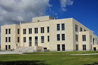
Chambers County is a county in the U.S. state of Texas. As of the 2020 census, its population was 46,571. The county seat is Anahuac.

<span class="mw-page-title-main">Oakland Acres, Iowa</span> City in Iowa, United States

Oakland Acres is a city in Jasper County, Iowa, United States. The population was 176 at the time of the 2020 census.

<span class="mw-page-title-main">Lakehills, Texas</span> CDP in Texas, United States

Lakehills is a census-designated place (CDP) in Bandera County, Texas, United States. The population was 5,150 at the 2010 census, making it the most populous place in Bandera County. It is part of the San Antonio Metropolitan Statistical Area.

<span class="mw-page-title-main">Bluetown-Iglesia Antigua, Texas</span> Former CDP in Texas, United States

Bluetown-Iglesia Antigua was a census-designated place (CDP) in Cameron County, Texas, United States. The population was 692 at the 2000 census. For the 2010 census the area was split into two CDPs, Bluetown and Iglesia Antigua. The communities are part of the Brownsville–Harlingen Metropolitan Statistical Area.

<span class="mw-page-title-main">La Feria, Texas</span> City in Texas, United States

La Feria is a city in Cameron County, Texas, United States. Its population was 7,302 at the time of the 2010 census. It is part of the Brownsville–Harlingen–Raymondville, the Matamoros–Brownsville, and the McAllen–Edinburg–Mission metropolitan areas.

<span class="mw-page-title-main">Beach City, Texas</span> City in Texas, United States

Beach City is a U.S. city in Chambers County, Texas, United States. The population was 3,221 at the 2020 census. It can now be considered as a part of Greater Houston.

<span class="mw-page-title-main">Old River-Winfree, Texas</span> City in Texas, United States

Old River-Winfree is a city in Chambers and Liberty counties, Texas, United States. The population was 1,315 at the 2020 census.

<span class="mw-page-title-main">Hawley, Texas</span> City in Texas, United States

Hawley is a city in Jones County, Texas, United States. The population was 634 at the 2010 census. Named for Congressman Robert B. Hawley, it is part of the Abilene metropolitan area.

<span class="mw-page-title-main">Dayton, Texas</span> City in Texas, United States

Dayton is a city in Liberty County, Texas, United States. The population was 8,777 at the 2020 census.

<span class="mw-page-title-main">Sunrise Beach Village, Texas</span> City in Texas, United States

Sunrise Beach Village is a city in Llano County, Texas, United States. The village was established in 1973. The population was 713 at the 2010 census.

<span class="mw-page-title-main">Garrison, Texas</span> City in Texas, United States

Garrison is a small town in Nacogdoches County, Texas, United States. The population was 789 at the 2020 census.

<span class="mw-page-title-main">West Orange, Texas</span> City in Texas, United States

West Orange is a city in Orange County, Texas, United States. The population was 3,459 at the 2020 census, an increase over the figure of 3,443 tabulated in 2010. It is part of the Beaumont–Port Arthur Metropolitan Statistical Area.

<span class="mw-page-title-main">New Chapel Hill, Texas</span> City in Texas, United States

New Chapel Hill is a city in Smith County, Texas, United States. The population was 620 at the 2020 census. It is part of the Tyler, Texas Metropolitan Statistical Area.

<span class="mw-page-title-main">West Lake Hills, Texas</span> City in Texas, United States

West Lake Hills is a city in Travis County, Texas, United States. The population was 3,444 at the 2020 census. The city developed rapidly in the 1970s and 1980s on the south side of the Colorado River.

<span class="mw-page-title-main">Liberty Hill, Texas</span> City in Williamson County, Texas, United States

Liberty Hill is a city in Williamson County, Texas, United States. The population was 3,646 at the 2020 census. Liberty Hill is part of the Greater Austin metropolitan area.

<span class="mw-page-title-main">Mont Belvieu, Texas</span> City in Texas, United States

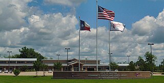
Mont Belvieu is a city in Chambers County in the U.S. state of Texas. It is just north of Interstate 10 along State Highway 146. The population was 7,654 at the 2020 census, an increase of nearly 100% from 3,835 in 2010. It is the site of the largest underground storage facility for liquefied petroleum gas in the US. The US LPG market pricing indicator is driven primarily by the Mont Belvieu market, and reported daily by the US Energy Administration.

References

  1. "2019 U.S. Gazetteer Files". United States Census Bureau. Retrieved August 7, 2020.
  2. 1 2 U.S. Geological Survey Geographic Names Information System: Cove, Texas
  3. 1 2 "U.S. Census website". United States Census Bureau . Retrieved January 31, 2008.
  4. 1 2 "Geographic Identifiers: 2010 Census Summary File 1 (G001): Cove city, Texas". U.S. Census Bureau, American Factfinder. Archived from the original on February 13, 2020. Retrieved July 27, 2015.
  5. "US Gazetteer files: 2010, 2000, and 1990". United States Census Bureau. February 12, 2011. Retrieved April 23, 2011.
  6. TSHA Online - Texas State Historical Association
  7. "Census of Population and Housing". Census.gov. Retrieved June 4, 2015.
  8. "Explore Census Data". data.census.gov. Retrieved May 23, 2022.
  9. "About the Hispanic Population and its Origin". www.census.gov. Retrieved May 18, 2022.
  1. Note: the US Census treats Hispanic/Latino as an ethnic category. This table excludes Latinos from the racial categories and assigns them to a separate category. Hispanics/Latinos can be of any race. [9]