
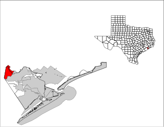
Galveston County is a county in the U.S. state of Texas, located along the Gulf Coast adjacent to Galveston Bay. As of the 2020 census, its population was 350,682. The county was founded in 1838. The county seat is the City of Galveston, founded the following year, and located on Galveston Island. The most-populous municipality in the county is League City, a suburb of Houston at the northern end of the county, which surpassed Galveston in population during the early 2000s.

Clear Lake Shores is a city in Galveston County, Texas, United States, located within the Houston–Sugar Land–Baytown metropolitan area. As of the 2020 census, the city population was 1,258.
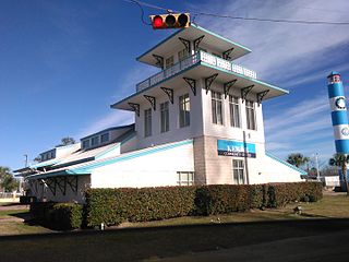
Kemah is a city in the U.S. state of Texas, southeast of Houston along west Galveston Bay. The city's population was 1,807 at the 2020 census, down from 2,330 at the 2000 census. Located in Galveston County, Kemah's main industry is shipping. Originally a small fishing town, the city has become a tourist destination for the area's restaurants and attractions, which are contained within the Kemah Entertainment District. In 2012 Kemah was ranked the top tourism spot in the Greater Houston area.

El Lago is a city in Harris County, Texas, United States. The population was 3,090 at the 2020 census.
Nassau Bay is a city in Harris County, Texas, United States, bordering the outermost southeastern edge of the city of Houston. It is located in the Clear Lake Area near Galveston Bay, directly adjacent to the Lyndon B. Johnson Space Center. The population was 5,347 at the 2020 census.

Taylor Lake Village is a city in Harris County, Texas, United States. The population was 3,704 at the 2020 U.S. census.

Webster is a city in the U.S. state of Texas located in Harris County, within the Houston–The Woodlands–Sugar Land metropolitan area. Its population was 12,499 at the 2020 U.S. census.

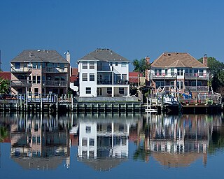
Seabrook is a city in Harris County, Texas, United States, with some water surface area located within Chambers County. The population was 13,618 at the 2020 U.S. census. Several fish markets line the city's waterfront, while antique shops and bed and breakfast establishments are found in the city's downtown area.
Friendswood is a city in the U.S. state of Texas. It is part of the Greater Houston metropolitan area. The city lies in Galveston and Harris counties. As of the 2020 census, the population of Friendswood was 41,213.

League City is a city in the U.S. state of Texas, in Galveston County, within the Greater Houston metropolitan area. The population was 114,392 at the 2020 census.

The Trinity River is a 710-mile (1,140 km) river, the longest with a watershed entirely within the U.S. state of Texas. It rises in extreme northern Texas, a few miles south of the Red River. The headwaters are separated by the high bluffs on the southern side of the Red River.
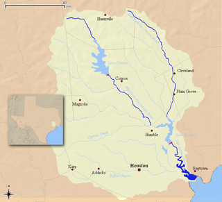
The San Jacinto River flows through southeast Texas. It is named after Saint Hyacinth. In the past, it was home to the Karankawa and Akokisa tribes.
The Allen Ranch, or Sam Allen Ranch, was one of the first and longest running ranches in the history of the state of Texas in the United States. The ranch was started a few years after the Texas Revolution in what is now southeast Houston and Pasadena. The ranch itself extended from Clear Lake to Harrisburg. The cattle range covered much of southeast Harris County and Galveston County covering many of the modern communities around Galveston Bay.

Cooper Lake State Park is a Texas State Park in Delta and Hopkins counties, about three miles (5 km) south of Cooper, Texas. The park is situated on Jim Chapman Lake, formerly known as Cooper Lake. There are actually two geographically separate units; the Doctors Creek unit 33°20′54″N95°40′08″W is located on the north side of the lake, in Delta County, while the South Sulphur unit 33°17′49″N95°39′35″W is located on the south side of the lake, in Hopkins County.

Houston, the most populous city in the Southern United States, is located along the upper Texas Gulf Coast, approximately 50 miles (80 km) northwest of the Gulf of Mexico at Galveston. The city, which is the ninth-largest in the United States by area, covers 601.7 square miles (1,558 km2), of which 579.4 square miles (1,501 km2), or 96.3%, is land and 22.3 square miles (58 km2), or 3.7%, is water.
Bayview is an area within unincorporated Galveston County, Texas, United States, that was formerly a more distinct community.
El Jardin del Mar is a community located in Seabrook, Texas, United States. Places within El Jardin have Seabrook, Texas postal addresses. Most of El Jardin's residents are those of the working class.
Armand Bayou is a bayou in U.S. State of Texas. It runs near Galveston Bay in Pasadena and the Clear Lake Area.

Caney Creek (Matagorda Bay) is a river in Texas that begins northwest of Wharton, flows generally southeast, and empties into the Gulf of Mexico near Sargent. The major waterway to the west is the Colorado River while the next major waterway to the east is the San Bernard River.

Christmas Bay is a small bay located on the Texas Gulf Coast in Brazoria County, Texas, immediately southwest of West Bay, near the Galveston Bay system's southwest corner. It is a minor estuary, one of a series of estuaries along the Gulf Coast of Texas, and receives the discharge from Bastrop Bayou, along with the adjacent coastal watershed. The bay is separated from the Gulf of Mexico by Follet's Island and connects with it through San Luis Pass and Cold Pass. Its minor extensions are Bastrop Bay to the north and Drum Bay to the southwest. The nearest city is Freeport, about 10 miles (16 km) to the southwest at the mouth of the Brazos River.


