Gwinear–Gwithian is a coastal civil parish in west Cornwall, England, United Kingdom. It includes the villages of Connor Downs, Gwinear, Gwithian, Reawla and Rosewarne. The parish is situated approximately two miles (3 km) east of Hayle two miles (3 km) west of Camborne.
Cheadle and Gatley was, from 1894 to 1974, an urban district of Cheshire, England.

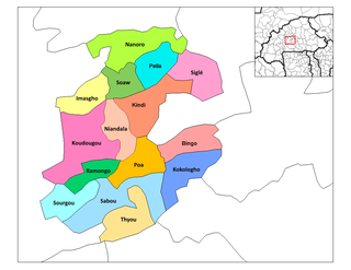
Grenadines is an administrative parish of Saint Vincent and the Grenadines. Its capital is Port Elizabeth.

The Pacific Remote Islands Marine National Monument is a group of unorganized, mostly unincorporated United States Pacific Island territories managed by the Fish and Wildlife Service of the United States Department of the Interior and the National Oceanic and Atmospheric Administration of the United States Department of Commerce. These remote refuges are "the most widespread collection of marine- and terrestrial-life protected areas on the planet under a single country's jurisdiction". They protect many endemic species including corals, fish, shellfish, marine mammals, seabirds, water birds, land birds, insects, and vegetation not found elsewhere.
Castillejo-Sierra is a municipality in Cuenca, Castile-La Mancha, Spain. It has a population of 48.

Runović is a village in the municipality of Runovići in Croatia, in the Split-Dalmatia County. It has a population of 2,409, 99.71% which are Croats. There are three settlements in the municipality:

German submarine U-383 was a Type VIIC U-boat of Nazi Germany's Kriegsmarine during World War II.
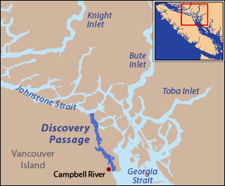
Discovery Passage is a channel that forms part of the Inside Passage between Vancouver Island and the Discovery Islands which lie off the British Columbia coast north of the Georgia Strait. It was named by Captain Vancouver for his ship, HMS Discovery. Most of the eastern shoreline of the passage is Quadra Island, with Sonora Island forming the shoreline at the northern end where Discovery Passage meets Johnstone Strait. The southern end of Discovery Passage enters the Strait of Georgia. It is 25 km (16 mi) in length and is typically about 2 km (1.2 mi) in width, less at Seymour Narrows which lies in the lower half of Discovery Passage.
Muga de Sayago is a municipality located in the province of Zamora, Castile and León, Spain. According to the 2004 census (INE), the municipality has a population of 472 inhabitants.
Pech Chenda is a khum (commune) of Phnum Proek District in Battambang Province in north-western Cambodia.

Mawé is a town in the Solenzo Department of Banwa Province in western Burkina Faso. As of 2005 it had a population of 2,329.
Kougri is a village in the Zam Department of Ganzourgou Province in central Burkina Faso. The village has a population of 4110.

Stary Janków is a village in the administrative district of Gmina Radzymin, within Wołomin County, Masovian Voivodeship, in east-central Poland. It lies approximately 5 kilometres (3 mi) south-east of Radzymin, 4 km (2 mi) north of Wołomin, and 24 km (15 mi) north-east of Warsaw.
Ébano, Mexico is a town and municipality in San Luis Potosí in central Mexico. Its name comes from the Spanish word for ebony.
Sambu is a village in Jõelähtme Parish, Harju County in northern Estonia.
Karujärve is a village in Saaremaa Parish, Saare County in western Estonia.
Nygren Point is a rocky point 4 nautical miles (7 km) southeast of Cape Broms, on the southwest side of James Ross Island. First seen and surveyed in 1903 by the Swedish Antarctic Expedition under Nordenskjold, who named it Cape Nygren after G. Nygren, Swedish chemist who contributed toward the cost of the expedition. It was resurveyed by the Falkland Islands Dependencies Survey (FIDS) in 1952. Point is considered a more suitable descriptive term for this feature than cape.

Stinker Point is a headland 7 km (4.3 mi) south of Table Bay on the west coast of Elephant Island, in the South Shetland Islands of Antarctica. It was mapped by the UK Joint Services Expedition to Elephant Island, 1970–71, and named after the southern giant petrels which breed there, "stinker" being an old sailors' name for the bird.
Tus is a river of the Province of Albacete, Spain.